The US flood data shift: What’s next?
Accessing comprehensive and reliable flood data in the US is becoming increasingly challenging. As state and local leaders seek new approaches to flood mapping, Fathom is here to help you make smarter, more resilient data choices.


Accessing comprehensive and reliable flood data in the US is becoming increasingly challenging. As state and local leaders seek new approaches to flood mapping, Fathom is here to help you make smarter, more resilient data choices.
Flood mapping in the United States is undergoing a major transformation. Access to public data is increasingly limited by coverage gaps, ageing update cycles and funding cuts, driving state and local agencies to look elsewhere for reliable flood data to complement existing data.
To help you navigate this shifting landscape, we explore how public and private sources can work together to achieve a more comprehensive view of risk, both now and in the future.
Jump to section:
Flood risk in the US is rising. A combination of increasingly intense extreme weather events, rapid urbanization and population shifts means that it’s critical for organizations and communities to have a full view of flood risk now and into the future.
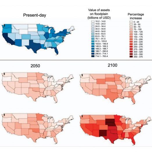
The US population exposed to flooding annually is projected to rise by 97% by 2050.
At the same time, the role of federal agencies in the US is changing. National institutions such as the Federal Emergency Management Agency (FEMA), the National Oceanic and Atmospheric Administration (NOAA) and the National Weather Service (NWS) are undergoing significant restructuring and state and local agencies are taking more responsibility for flood risk management and emergency response.
However, across much of the US, many of these agencies are facing the same challenge with existing public data: inconsistent, outdated flood data, with limited funding to support the detailed studies required, and the pressing need to understand and protect against rising flood risks.
With increasing flood risk and a fast-evolving regulatory and policy space, the need for accurate, full coverage data is high. State and local agencies are widening the net in their search for data that meets those criteria and gives them an accurate view of risk today and long into the future. Collaboration between public and private data will take a central role in this new era of flood data.
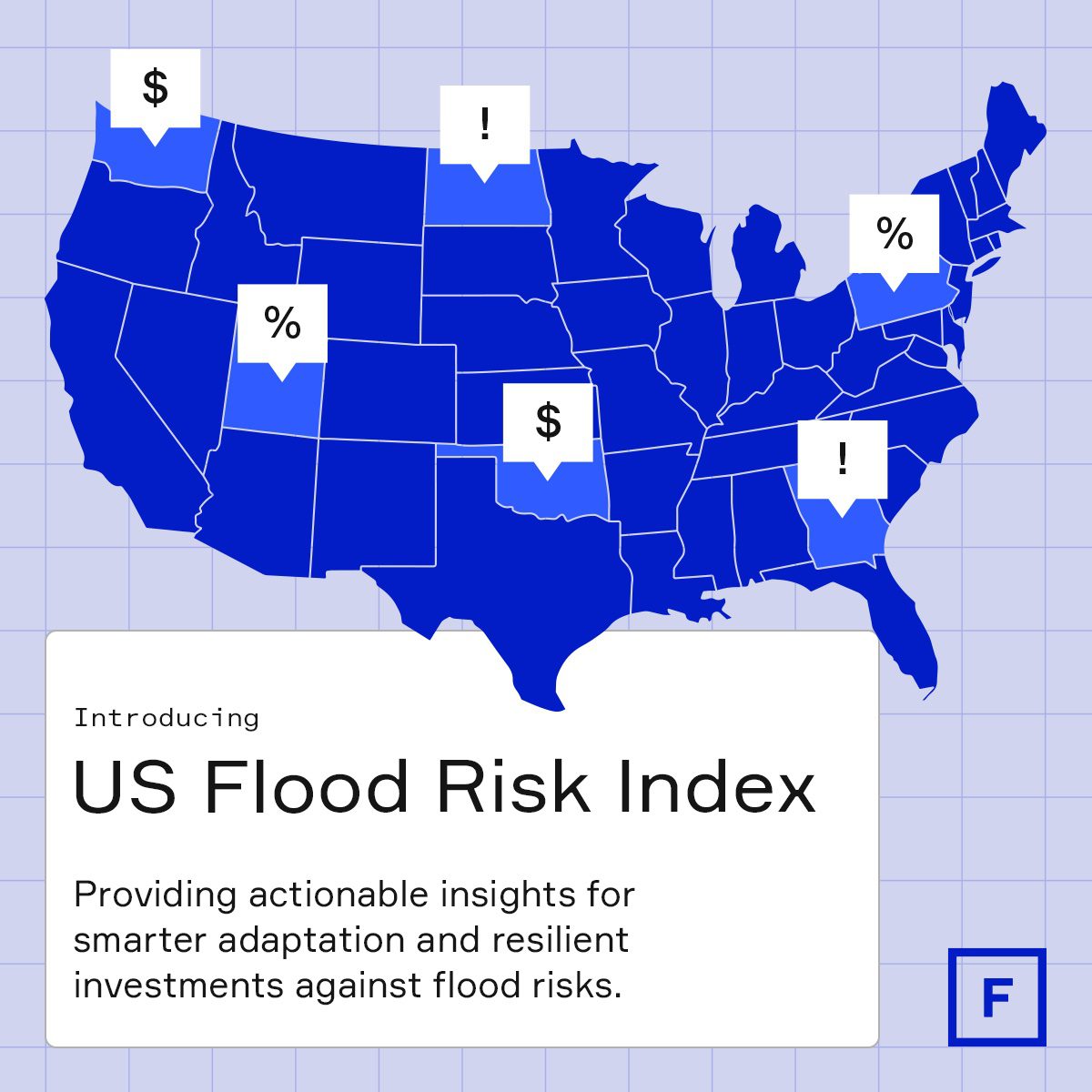
US Flood Risk Index
Fathom’s US Flood Risk Index is an interactive tool that gives floodplain managers, planners and risk engineers a detailed view of flood risk in their state.
Underpinned by high-resolution multi-return-period flood hazard maps, the index reveals where flood risk is expected to rise the fastest and how well-prepared states are to address the risk by analyzing the coverage and age of FEMA’s Flood Insurance Rate Maps (FIRMs).
Key drivers in the shifting flood data landscape
There are a number of reasons for this data shift:
Rapidly evolving flood risk and resilience policies are outpacing the static public datasets traditionally used to support them.
Many public flood datasets rely on outdated methods and assumptions, a challenge compounded by the disbanding of the TMAC and the resulting loss of technical guidance.
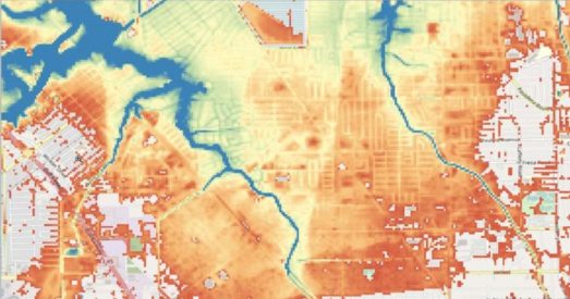
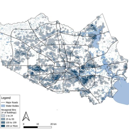
Flood maps produced by FEMA currently only cover approximately 60% of the continental US and only 19% is covered by maps less than 10 years old. Not all river channels are captured, and pluvial (flash) flooding is not represented, leaving current development and risk conditions unrepresented.
Public flood maps are not designed to account for future climate-driven changes, limiting their usefulness for long-term planning and resilience investments.
Increasing regulatory and disclosure requirements demand more granular, defensible flood risk data than many public products can provide.
When official maps fail to reflect observed flood impacts, agencies and officials face heightened scrutiny and eroding public trust.
Reduced federal funding for mitigation and mapping, including the discontinuation of FEMA’s Building Resilient Infrastructure and Communities (BRIC) program, has constrained the ability to modernize and maintain public flood data.
Many states, counties and cities in the US are already adopting hybrid approaches
Explore the challenges and opportunities of the evolving flood data landscape, and how state agencies are combining public and private data sources to support smarter, more resilient decision-making
Flood mapping has evolved dramatically in the past decade. Driven by the availability of huge, complex data sets, increased computing power and revolutionary technology such as machine learning, private flood data providers are reshaping how flood maps are created and the speed at which they are made available.
With limitations in publicly available data, these alternative data sources are filling in the gaps to give a full view of flood risk. But it’s not a case of choosing between public and private sources. The solution lies in effective collaboration between the two.
Key to successful collaboration is rigorous data validation. Historically, private sector validation has been lacking and this has, in turn, limited public sector adoption of private data. But this is changing.
Fathom’s data are independently peer-reviewed and validated, and public sector bodies are increasingly carrying out their own validation exercises, and comparing and benchmarking private data against other data such as local base level engineering models.
The role of hybrid flood models
A hybrid flood model that uses national-scale datasets, such as those from FEMA, and complements them with private-sector tools and physics-based models is the best way to overcome the critical gaps in flood mapping across the US.
Hybrid models can inform decisions and advance practical strategies for mitigating current and future flood risk to build resilient communities. Whether you’re assessing infrastructure vulnerability, reviewing development proposals or updating mitigation plans, public-private hybrid models hold the key.
Collaborating with a private data provider provides numerous benefits. Primarily, it is about plugging the data gap and allowing for long-range planning to build resilience.
However, the ability to accelerate project timelines and support tightening budgets is also key. Although there are cost savings, some of the licensing costs can be high, especially for public sector organizations. For that reason, it’s crucial to be sure that the data you’re using is fit for purpose.
Steps to finding an effective data solution
Define the use case
Having a clear understanding of what you need the data to achieve is crucial. Some types of flood data, for example, are more suitable for regulatory purposes than others. Once you are clear about that, you can better assess and find the combination of data sources that is right for your use case.
Gap analysis
Assess your current flood data portfolio to identify gaps and limitations in the maps and models you rely on.
Explore what options exist to solve data gaps
Consider what blend of public and private data is available and most suitable. Combining publicly available base maps with high-resolution, climate-aware data from providers like Fathom improves precision and decision-making.
Dig deeper into the data
Examine the sources and assumptions behind any flood model; transparency is key. It should show you where uncertainty lies and the methodologies should be fully available for you to conduct your own evaluation.
Ensure the data is fit for purpose
No model is 100% accurate, but selecting scientifically robust, peer-reviewed and validated datasets ensures your decisions are defensible.
Key considerations when evaluating flood models
Whether you’re working on permitting, design, or resilience planning, these questions will help ensure you’re working with a flood model that matches the precision and transparency your project requires.
US Flood Map

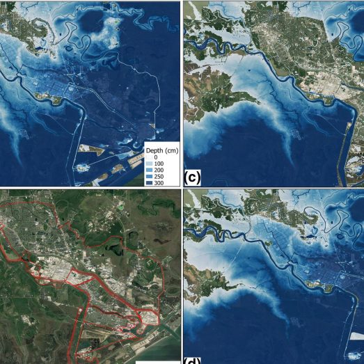
Scientifically validated, large-scale flood mapping for the United States, with local-scale precision. Fathom’s US Flood Map utilizes cutting-edge data to offer comprehensive and climate-driven flood risk information across fluvial, pluvial and coastal perils and all climate scenarios and time horizons.
Climate Dynamics Framework

Fathom delivers globally consistent, climate‑conditioned flood risk data and models that enable organizations to quantify present and future climate risk for better decision‑making, planning and regulatory compliance.
FathomDEM+ terrain dataset

FathomDEM+ is Fathom’s next-generation terrain data, incorporating the latest LiDAR (Light Detection and Ranging) and applying state-of-the-art machine learning techniques. Available as a standalone dataset, it includes Metadata to provide information on native resolution, date of capture, source data type and certainty rank to provide full transparency.
In a comprehensive benchmarking study published in the peer-reviewed journal Remote Sensing, FathomDEM was recognized as a top-performing global digital elevation model. It also empowers users to perform their own validation and benchmarking studies for further confidence in the quality of the data.
Discover the next generation of global terrain data
Navigating the future of US flood mapping
Watch our panel discussion exploring how private-sector tools, physics-based models and national-scale risk datasets are being combined to fill critical gaps in flood mapping, and what this means for state and county-level resilience planning and decision-makers.
The key role of transparency
Crucially, the methodologies underpinning Fathom’s flood maps and models are scientifically validated, peer-reviewed and the results published in established research journals.
Validation is an essential part of proving flood data fit for purpose. Fathom’s flood data has been extensively independently validated, not only in peer-reviewed scientific studies but in real-life industry applications. You can read about some of these projects below:
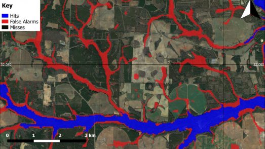
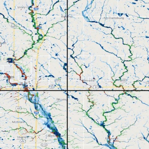
Iowa Flood Center validation project: Benchmarking Fathom’s US Flood Map
Certifying a flood model for statewide use by the Florida Loss Commission

Validation of a 30m resolution flood hazard model of the conterminous United States
The first peer-reviewed validation of a continental-scale, high-resolution flood hazard model; this paper won the prestigious AGU Editors’ Choice Award in 2018.
Inequitable patterns of US flood risk in the Anthropocene
Climate change will have major impact on cost of flooding, according to pioneering research led by Dr Oliver Wing, Chief Research Officer at Fathom
A benefit-cost analysis of floodplain land acquisition for US flood damage reduction
Working with colleagues at the Nature Conservancy, we published a Nature Sustainability paper examining the cost-benefit ratios of acquiring floodplain land relative to future damages in the US. [Due to external constraints this paper is not open access, so please contact us for a pre-print copy].
Attributable human-induced changes in the magnitude of flooding in the Houston, Texas region during Hurricane Harvey
Using Fathom’s US flood model to examine how climate change exacerbated the impact of Hurricane Harvey, which devastated Houston in 2017.
Combined Modeling of US Fluvial, Pluvial, and Coastal Flood Hazard Under Current and Future Climates
A paper describing our most recent iteration of the US model, covering inland and coastal flooding across multiple time horizons.
Estimates of present and future flood risk in the conterminous United States
A collaboration with the US EPA and The Nature Conservancy to show that: a) previous estimates have significantly underestimated exposure of US population to flood risk; and b) that population and GDP growth are likely to cause this to further increase in future.
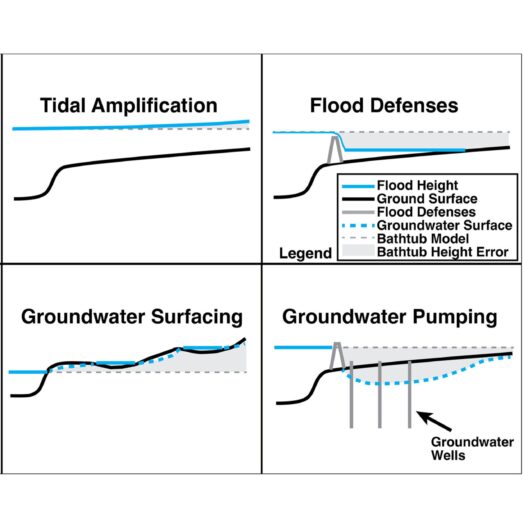
Flooding is not like filling a bath
New commentary in Earth’s Future journal explains why the bathtub method should not be used in flood modeling.
Social inequalities in climate change-attributed impacts of Hurricane Harvey
This research uses attribution science to examine the influence that climate change had on the damage caused by Hurricane Harvey in 2017.
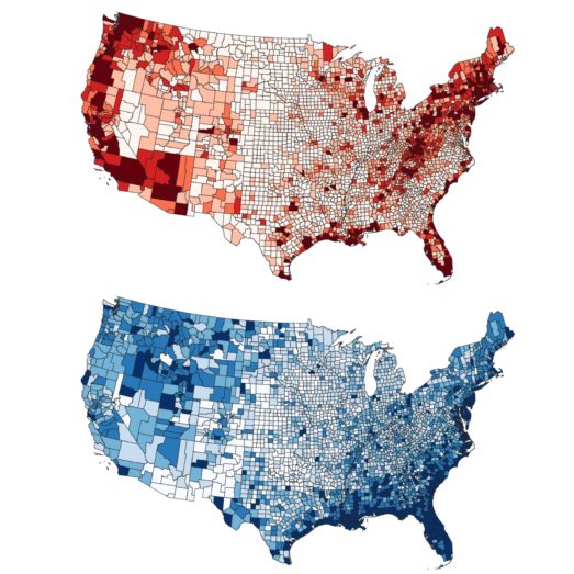
Flood exposure and social vulnerability in the United States
This study explores the geography of flood exposure and social vulnerability in the conterminous United States, and finds racial minorities and mobile-home occupiers in rural Southern communities to be over-represented where exposure and social vulnerability converge.

Increased Flood Exposure Due to Climate Change and Population Growth in the United States
In this paper we explore projected future changes to flood exposure due to anthropogenic climate change and population growth.
How it works in practice
Fathom’s US flood and climate data overcome traditional mapping challenges, enabling flood managers and practitioners, engineers, climate specialists and GIS analysts to rapidly access and analyze scientifically robust data early in any project.
As a leading provider of award-winning flood models, we help engineering consultancies and public-sector organizations embed meaningful risk governance into their practices.
We have worked with a long list of public sector bodies, who have combined our data with public and other private data to conduct risk assessments and flood resilience programs across the US. They include: