Global Terrain Data – FathomDEM+
Closing the LiDAR gap: Unlocking global accuracy with advanced machine learning techniques.
Introducing FathomDEM+: the next generation of terrain data
FathomDEM+ applies the latest advances in geospatial machine learning and seamlessly integrates LiDAR data to deliver the most accurate, bias-corrected global terrain model to date.
FathomDEM+ comprises best-in-class global elevation data along with associated terrain metadata at ~30m and ~10m resolution. It combines machine learning-enabled FathomDEM and one of the largest databases of LiDAR (the gold standard in terrain data accuracy) in the world. The result is one of the most accurate global digital elevation models available.

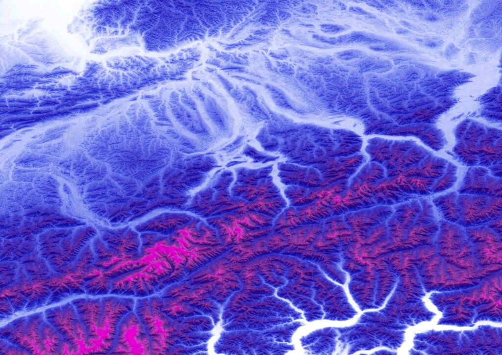
The most accurate digital elevation model to date
High quality LiDAR and IfSAR are the most accurate ways to map our world for the purposes of flood mapping, but most of the world isn’t covered as it is an expensive and time-consuming process. The goal of creating FathomDEM was to solve this problem and provide a real-world solution to areas where it is unfeasible to use LiDAR and IfSAR.
Proven performance: Independently verified as a global leader
While we built FathomDEM+ to be the most accurate model available, you don’t have to take our word for it. In a comprehensive benchmarking study published in the peer-reviewed journal Remote Sensing, FathomDEM was recognized as a top-performing global digital elevation model.
The research conducted by Guth et al. (2025) evaluated FathomDEM against other leading global datasets, including Copernicus DEM (CopDEM), ALOS AW3D30, and GEDTM. The findings were clear: FathomDEM and Copernicus DEM were crowned the “Best Global DEMs” currently available. The authors noted it “consistently performs best” for users who require high-fidelity elevation data.
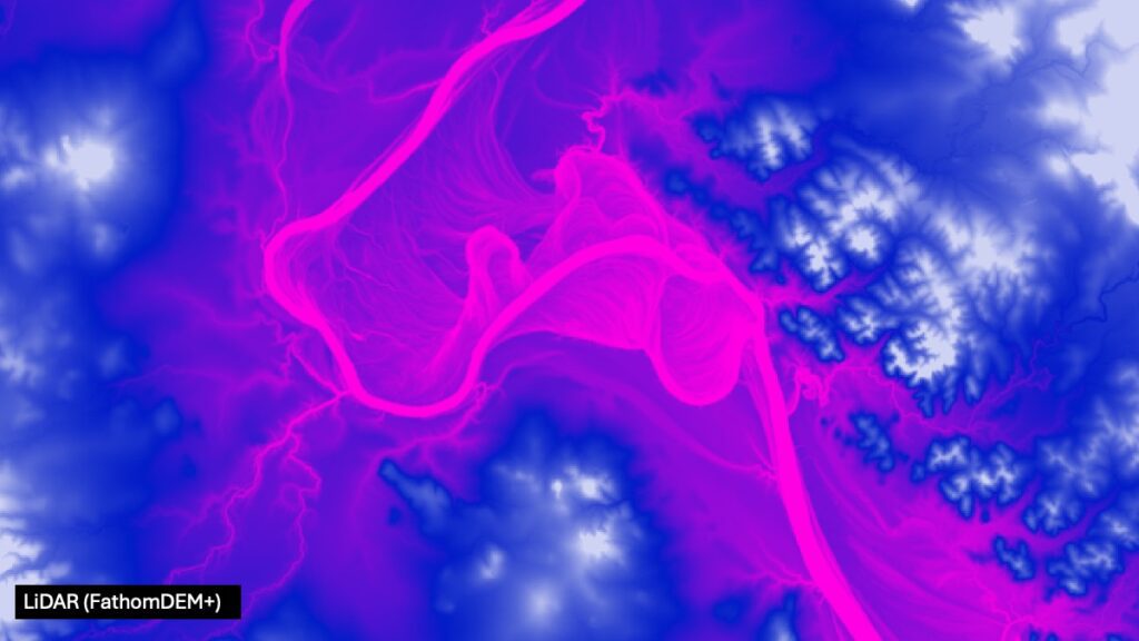
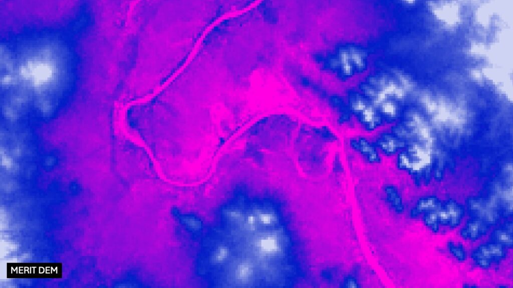
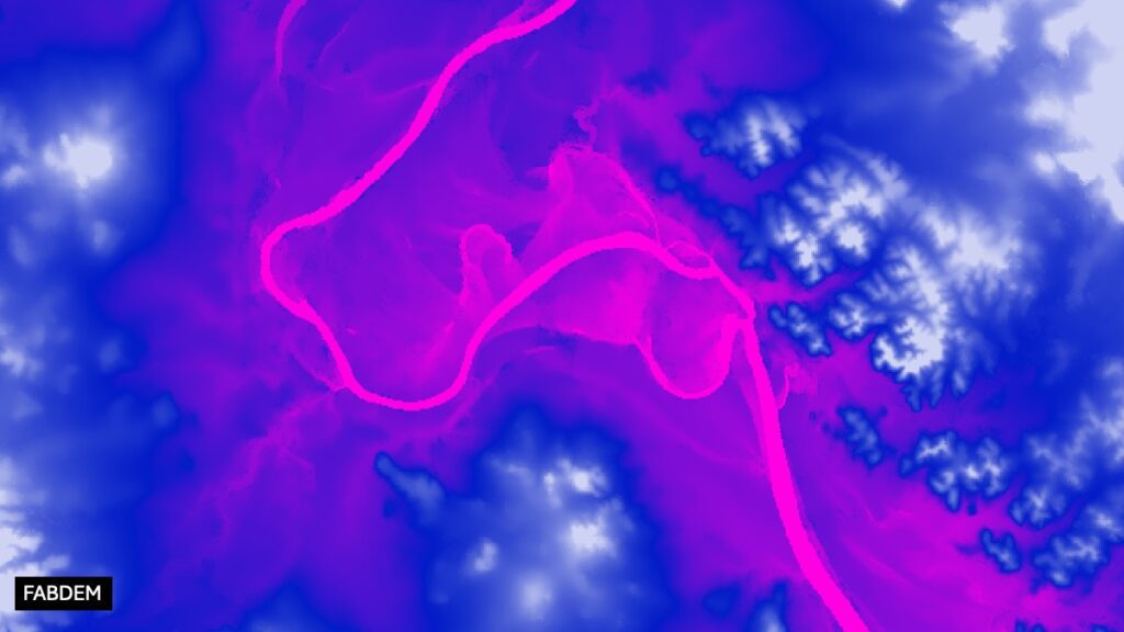
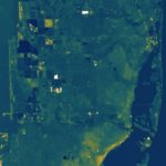
FathomDEM+ performs exceptionally well, even compared to other highly accurate datasets. Tab between the images below to compare DEMs visually.
By bridging the gap between expensive, localized LiDAR and traditional global satellite data, FathomDEM+ provides a validated, high-resolution foundation for flood modeling and geospatial analysis.


From FathomDEM to FathomDEM+
Two powerful features in one integrated tool
FathomDEM | Base digital terrain model (DTM) developed by Fathom
An improved global terrain map that uses a hybrid Vision Transformer model to provide an improved method of modeling. FathomDEM uses a novel application of advanced machine learning techniques. This halves the error compared to the digital elevation models currently recognised as the most accurate.
FathomDEM+ | Base DTM developed by Fathom, overlaid with LiDAR
Most of the world’s publicly available LiDAR is seamlessly blended to create one cohesive dataset. Where LiDAR is not available, FathomDEM is incorporated to create FathomDEM+.
Bringing to the market best-in-class digital elevation data
Novel machine learning approach
Advanced AI techniques to produce terrain data that compares to the gold standard of LiDAR.
Bare-earth elevation
All elevation data represents the underlying terrain, not the tops of tree canopies and building roofs.
Global scope and resolution
Offers ~10m resolution for areas with enhanced data, including 29 countries.
Available globally at ~30m resolution (excludes Antarctica).
Metadata
Fathom uses a “glass box” methodology built on peer-reviewed, publicly available research. Our Metadata provides information on native resolution, date of capture, source data type and certainty rank to provide full transparency.
Consistent accurate data, where the hard work has been done for you
Seamlessly blends thousands of disparate data sources into one consistent product, including geoid and datum corrections and coping with multiple resolutions. Removing operational hurdles for those who need accurate data.
Independently validated
Developed out of decades of academic research and global datasets, with transparent methodologies.
Independently shown to perform best when reviewed against other DEMs. Learn more >
A framework for building FathomDEM+

Raw data
The building blocks of FathomDEM:
- Copernicus satellite digital surface model
- Homogenized high fidelity and resolution DTM datasets such as LiDAR and IfSAR
- Other predictor data such as tree density and building height estimates

Machine learning
A more powerful technique using deep neural networks to correct errors:

FathomDEM
AI application halves the accuracy error of current maps:

Combiner method
Blending the data and ensuring consistency:

FathomDEM+
The end result: one of the most accurate and complete global digital elevation models:
- Copernicus satellite digital surface model
- Homogenized high fidelity and resolution DTM datasets such as LiDAR and IfSAR
- Other predictor data such as tree density and building height estimates
Unlocking the power of machine learning
Fathom uses bespoke machine learning tools, also known as deep neural networks to halve the accuracy error of current maps.
FathomDEM+ applies the very latest in geospatial AI. Deep neural networks (a hybrid Vision Transformer (ViT) and a Convolutional Neural Network (CNN)) correct terrain biases with unprecedented accuracy. The model simultaneously learns from global and local context. This allows it to deliver cleaner surfaces, fewer missing features and more stable elevation values. It’s the ideal solution for organizations that value accuracy, innovation and transparency in geospatial analytics.
Discover where Fathom’s terrain data sits in our full Product Stack
Closing the LiDAR gap – Why it matters for flood modeling
FathomDEM+ uses a hybrid vision transformer and convolutional neural network approach to correct surface biases with exceptional accuracy. It learns from both global and local context to produce a bare-earth terrain model with minimal noise and more accurate elevation values.
Terrain is a critical component of simulating flooding. To learn more about what makes for a good flood model, take a look at our insight: Questions to ask before trusting your flood model.
The result when applied to flooding simulations: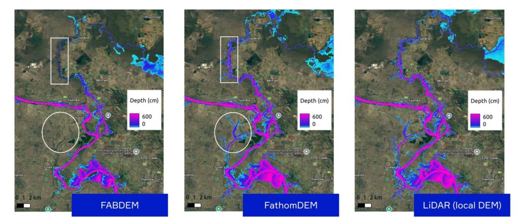
Overlaid with publicly available LiDAR where possible, it delivers the best of both worlds: the gold standard of LiDAR accuracy, and the next best everywhere else.
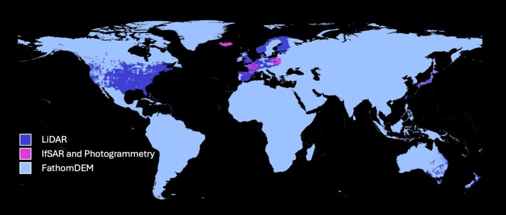
Coverage of FathomDEM+ globally
By combining FathomDEM with available LiDAR and IfSAR, Fathom offers best-in-class global elevation data at ~30m resolution globally with ~10m resolution in enhanced regions.
Over 10 million km² and 29 countries benefit from LiDAR or IfSAR coverage.
LiDAR is still the gold standard of terrain data accuracy. Where LiDAR is not available, however, FathomDEM fills in the gaps with state of the art machine learning to replicate the accuracy of LiDAR.
Coverage of FathomDEM+ in North America
Over 90% of the population of the US and Canada is covered by gold-standard LiDAR elevation.
More than 94% of buildings in the conterminous US are covered by gold-standard LiDAR elevation data available from federal and state agencies that Fathom has compiled.

Coverage of FathomDEM+ in Europe
Fathom’s compiled LiDAR dataset covers over 2 million km² in Europe.
LiDAR coverage of over 300 million people, with high quality FathomDEM coverage in other areas.

Beyond flooding: Accurate terrain data with a wide range of applications
Fathom is known for its world-leading flood maps and models, for which accurate terrain data is a critical component. FathomDEM+ will underpin the next generation of Fathom’s global flood maps, beginning with Fathom’s updated Global Flood Map. It is also available as a standalone dataset.
A digital elevation model of this calibre has a wide range of applications across many industries, including:
— Flood and hydraulic modeling
— City, state and national infrastructure planning and hazard mitigation
— Digital twin/digital simulation and GIS platforms
— Large insurers and reinsurers constructing custom-made pricing models
— High-quality flood maps derived from FathomDEM+
— Water, flood, sanitation and hygiene risk management and policy
— Disaster risk, response and emergency modeling
— Conservation, ecology and climate adaptation analysis
Location-based platforms
— Flight and vehicle simulations
— Video games and VR
— Navigation and route optimization software
Watch our launch webinar
Explore the product in more detail and learn from the experts behind the model in our watch on-demand launch webinar
Featuring speakers:
- Head of Engineering – Gavin Lewis
- Principal Machine Learning Engineer – Dr Chris Lucas
- Chief Scientific & Product Officer – Dr Oliver Wing
Accessing FathomDEM+

Fathom API
Gain seamless access to Fathom’s entire Global Terrain Data or select a specific region using our cloud-based API.

Fathom Portal
Visualize the data via Fathom’s interactive in-house platform. If you are interested in this solution, you can trial the platform using Fathom sample data for free.

On-prem
Integrate your terrain data with your internal systems and host the data on-site, through the provision of GeoTIFF files.

Partners
Fathom data is available through a range of partners.
Recent research
FathomDEM Global Terrain Map

Using FABDEM to assess flood risk in the Central Highlands of Vietnam
Bare-earth DEM generation from ArcticDEM and its use in flood simulation

A 30 m global map of elevation with forests and buildings removed
A digital elevation model, or DEM, is a digital model representing Earth’s terrain. Often shown as a grid where each pixel shows an elevation value.
Digital elevation models have a wide range of use cases from flood risk modeling to gaming. Any business looking to build an accurate view of the terrain of an area will use a DEM, whether that’s in risk models for insurance, infrastructure projects, resilience planning and digital twins, or through to agriculture, video games and self-driving cars.
While FathomDEM is the base digital terrain model, FathomDEM+ is FathomDEM with high-quality LiDAR data overlaid.
FathomDEM is a high quality global terrain map that uses a hybrid Vision Transformer model. This halves the error compared to the digital elevation models currently recognized as the most accurate. FathomDEM+ then seamlessly blends FathomDEM with most of the world’s publicly available LiDAR to create one cohesive dataset.
Digital surface models (DSMs) – DSMs represent not only the Earth’s terrain, but all surface objects upon it. This includes features like trees and buildings, which when modeling a peril like flooding can drastically alter the elevation and distort simulated flood severity.
Digital terrain models (DTMs) – For professionals looking to model natural hazards, elevation values instead must represent the Earth’s terrain surface with surface features removed. Traditionally, global DEMs have contained surface objects such as forests and buildings due to the complexity of removing bias at such a large scale. Some existing DEMs, such as MERIT, have some features removed but not others (e.g. MERIT removes forests but not buildings).
Digital elevation models (DEMs) can be split into two categories, digital surface models (DSMs) and digital terrain models (DTMs). We explain this in more detail above. FathomDEM+ is a DEM but more specifically is a digital terrain model – showing an accurate representation of the earth’s terrain with objects on the surface (such as buildings and forests) removed.
References to Copernicus DEM: © DLR e.V. 2010–2014 and © Airbus Defence and Space GmbH 2014–2018 provided under COPERNICUS by the European Union and ESA; all rights reserved. Produced using Copernicus WorldDEM-30 © DLR e.V. 2010–2014 and © Airbus Defence and Space GmbH 2014–2018 provided under COPERNICUS by the European Union and ESA; all rights reserved.