Partners

Partners are a vital element of the Fathom ecosystem and help put our data in the hands of those who need it

Fathom's US Flood Map - Memphis 200 flood simulation
A complete digital elevation map of Texas’ terrain was produced during the project.
Diagrams of maps validating Fathoms Global Flood Map
Dr. Niall Quinn presenting at EGU
Niall and Andy - Fathom
NASDAQ welcomes Fathom to the NASDAQ Risk Modelling Service
Global Terrain Data example image from FathomDEM+
The UN
the Fathom team at EGU23 in front of the welcome sign

Collaboration is central to how Fathom drives innovation and transforms flood risk information.

We work closely with a diverse network of academic and commercial partners to advance the science of flood modelling and translate research into practical, decision-ready insights.

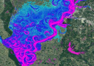
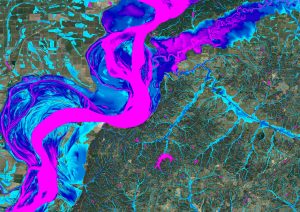
Our strong academic pedigree underpins this approach. Ongoing partnerships with leading universities and research institutions ensure our methods remain at the forefront of flood science, while collaboration with commercial organisations enables our data to be embedded into real-world applications. Together, these partnerships ensure Fathom’s data is licensed and deployed across a wide range of market sectors, putting robust flood risk information into the hands of those who need it most.

Distribution partners

Fathom works with distribution partners to expand access to its flood risk intelligence. Partners integrate Fathom’s high-resolution flood data into their own platforms and services, enabling clients to make faster, more informed decisions around risk assessment, planning and project development.

Explore our distribution partners

Client and project partners

Fathom collaborates with clients and project partners by providing high-resolution flood risk data and insights. This support helps teams assess site-specific risk, inform planning and design, and make faster, more confident decisions throughout project development.

Explore our client and project partners

Research partners

Fathom works with leading universities and research institutions to advance flood science by sharing high-resolution data, models and analytical insights. These collaborations help improve understanding of flood risk, test new approaches and drive innovations in predictive modeling and risk assessment.

Explore our research partners

Interested in becoming a partner? Get in touch.

Distribution partners

Swiss Re

The Swiss Re Group is one of the world’s leading providers of reinsurance, insurance and other forms of insurance-based risk transfer. Fathom flood maps (including Global and US Flood Maps) have been integrated into Swiss Re’s CatNet® risk assessment platform, making Fathom’s high‑resolution, full‑peril flood hazard data (pluvial, fluvial, coastal) available to CatNet® users for underwriting and portfolio risk analysis.

Visit website

Climate X

Fathom’s Global Flood model has been embedded into Climate X’s platforms to create the most comprehensive and actionable global climate model stack available on the market, combining water, wind, fire and earth perils with adaptation intelligence to empower faster data-driven decision-making.

Fathom’s work with Climate X

Correntics

Correntics is a Swiss climate risk analysis provider that empowers companies to anticipate and mitigate emerging risks from weather and climate extremes. Correntics’ Software-as-a-Service (SaaS) solution integrates Fathom’s Global Flood Map, enabling businesses’ internal risk management in various industries, including agriculture, chemical, logistics, and financial, but also partnering consulting firms to increase the efficiency and accuracy of physical climate risk assessments.

Visit website

ICE

Fathom scientific flood data has been integrated into the ICE Global Climate Risk Solution to offer users a detailed, building-level view of flood risk.

Visit website

FIS

FIS is a leading financial technology company providing solutions to financial institutions, businesses and developers. For more than 50 years, leading financial institutions and businesses have relied on FIS financial technology to power their mission-critical operations. Today, FIS’s technology helps their clients unlock new growth opportunities by cutting through complexity and bringing harmony in how they store, move and put money to work.

Visit website

MSCI

MSCI is a leading provider of mission-critical decision support tools and services for the global investment community. Fathom’s global flood risk intelligence is being used in MSCI’s new physical risk solution, MSCI GeoSpatial Asset Intelligence. As a result of the collaboration, MSCI clients will now have access to the granular flood risk intelligence required to make informed decisions about their portfolio or loan book exposure to flood risks.

Visit website

Oasis

The Oasis Loss Modelling Framework provides an open source platform for developing, deploying and executing catastrophe models. It uses a full simulation engine and makes no restrictions on the modelling approach.

Visit website

Verisk

Verisk is a global data analytics and risk assessment company that supplies insurers with predictive models, weather & hazard data and underwriting insights to support pricing and claims insights.

Visit website

Jacobs Flood Modeller

Flood Modeller is an industry-leading software platform which enables engineers and scientists to deliver faster and more accurate results by simplifying the modeling of river, surface water, and urban drainage systems. It enables users to confidently understand flood risk and develop optimal solutions to manage the impacts of climate change.

Visit website

Carto

Carto provides modern spatial analytics built for the cloud, enabling users to analyze, visualize, and develop with spatial data at limitless scale. Fathom’s Risk Scores are now available in Carto’s Data Observatory, helping users understanding flood risk at scale.

Fathom’s work with Carto

Client and project partners

Aon

Aon’s catastrophe model developers, Impact Forecasting, enable firms to analyse the financial implications of catastrophic events and achieve a greater understanding of their risks.

Fathom’s work with Aon

WSP

WSP is one of the world’s leading professional services firms, uniting its engineering, advisory and science-based expertise to shape communities to advance humanity. From local beginnings to a globe-spanning presence today, WSP operates in over 50 countries and employs approximately 75,000 professionals, known as Visioneers. Together they pioneer solutions and deliver innovative projects in the transportation, infrastructure, environment, building, energy, water, and mining and metals sectors.

Visit website

The World Bank

With 189 member countries, the World Bank Group is a unique global partnership fighting poverty worldwide through sustainable solutions. Fathom have worked with the World Bank on multiple projects, providing hazard information in Belize, Tanzania, Argentina and Vietnam.

Fathom’s work with the World Bank

Vave

Vave is an MGA offering algorithmically underwritten commercial property, homeowners property and flood insurance in the United States with instant quote-and-bind decisions.

Fathom’s work with Vave

ImageCat

ImageCat provides specialist risk management technology includiding exposure data, cat modelling and event response tools to insurers, helping them to assess and manage disaster risk

Visit website

Climate Engine

The planet is experiencing unprecedented rates of change. Climate Engine leverages the world’s best earth observation science to help you to understand the risks and capture opportunities specific to your industry.

Visit website

Deltares

Fathom have partnered with Deltares to deliver continental-scale flood catastrophe models. Combining their expertise in generating long synthetic hydrological time series with our hydraulic modelling toolkit, we specialise in producing spatially coherent flood event sets across large areas.

Visit website

AXA

Fathom jointly develop and pubish the methods of continental-scale flood risk models.

Fathom’s work with Axa

FEMA

The Federal Emergency Management Agency (FEMA) is a US Department of Homeland Security agency, responsible for coordinating federal responses to disasters. Fathom provided FEMA with a more accurate, up-to-date picture of US flood risk which informed how the NFIP prices insurance.

Visit website

GFDRR

The Global Facility for Disaster Reduction and Recovery (GFDRR) is a global partnership that helps low- and middle-income countries better understand and reduce their vulnerability to natural hazards and climate change. GFDRR collaborated with Fathom to produce event response data, including in the wake of Cyclone Idai. The GFDRR have also licensed Fathom’s entire global catalogue, working with Fathom to produce data to sit behind the Think Hazard! tool.

Fathom’s work with GFDRR

FCDO

The Foreign & Commonwealth Office (FCDO) is a ministerial department, supported by 11 agencies and public bodies. Fathom supports the FCDO by producing event response bulletins and conducting ongoing research and development to improve their quality and timeliness.

Visit website

Risk Footprint

RiskFootprint™ provides fast, accurate and affordable risk scores and quantitative reports for 14 risks including: floods, tornados, wildfire, drought and climate change for any property in the US in seconds. RiskFootprint™ helps Clients make their buildings safer, more sustainable and resilient.

Visit website

Aqua Strategies

Aqua Strategies Inc. is a Texas-based consultancy providing water resources planning, modelling, science and engineering solutions for water scarcity, water quality, flood risk and nature-based ecological restoration. Aqua Strategies helps clients develop well thought-out solutions, grounded in sound science and responsive to the needs of diverse stakeholders.

Visit website

Texas Water Development Board

Texas Water Development Board uses Fathom data, and others, to accelerate the development of the first statewide flood planning program in the absense of publicly available flood data.

Fathom’s work with TWDB

ERM

ERM is the largest global pure-play sustainability consultancy, partnering with the world’s leading organizations to create innovative solutions to address environmental, social and governance challenges while driving sustainable growth and resilience. Fathom’s globally consistent flood risk data strengthen enterprise risk management strategies and regulatory reporting for large firms the world over with The Climate Impact Platform by ERM.

Fathom’s work with ERM

Florida Deptartment of Environmental Protection

The Florida Department of Environmental Protection is the Florida government agency responsible for environmental protection. Fathom filled the data gap to enable a statutorily required statewide flood vulnerability assessment as part of Florida’s Statewide Flooding and Sea Level Rise Resilience Plan.

Fathom’s work with Florida

Taylor Engineering

Taylor Engineering offers comprehensive solutions for water-related projects, from design to construction. Fathom partnered with Taylor Engineering to deliver the statewide flood vulnerability assessment as part of Florida’s Statewide Flooding and Sea Level Rise Resilience Plan.

Visit website

BirdsEyeView

BirdsEyeView is a cloud-based platform that enables Underwriters to model, monitor and visualise natural catastrophe exposures and run probablistic risk analytics in real time.

Visit website

Eigen Risk

EigenRisk is an insurtech platform offering catastrophe and climate risk analytics, geo-visualisation and modeling tools to help insurers, brokers and risk-managers respond to evolving hazard exposures

Visit website

Network Rail

Network Rail own and manage some of Britain’s biggest and busiest railway stations. Fathom’s climate-conditioned data provided the consistent and detailed view of risk that was crucial to Network Rail’s climate adaptation strategy.

Fathom’s work with Network Rail

Research partners

University of Bristol

We continue to forge a close academic partnership with the University of Bristol, continually publishing our research in world-leading scientific journals. Work to date has entailed: validation of our US and global flood maps, development of a US cat model, and the uncovering of revolutionary insights into flood risk quantification globally.

Visit website

NASA

NASA use Fathom’s flood hazard data, including in the wake of Hurricane Harvey when they were used to produce loss indices. Fathom have also joint-coordinated NASA’s Flood workshops.

Visit website

Google

Fathom partnered with Google to aid in our unprecedented scientific validation of the Fathom-US flood layers. In particular, we used Google Earth Engine – Google’s cloud-based platform for planetary-scale geospatial analyses – to compare our flood model to observations and local models of flood events, providing objective and public quantification of the skill of our modelling techniques.

Visit website

The Nature Conservancy

The Nature Conservancy has been a long-term academic partner, leading to multiple peer-reviewed publications in the scientific literature with many more on the horizon. We work closely with TNC scientists to reveal new insights into US flood risk in leading journals, aiding them in identifying effective strategies for natural floodplain conservation.

Fathom’s work with the Nature Conservancy

Wharton Risk Center

Fathom works with the Wharton Risk Center on a variety of projects relating to flood risk in the US, leveraging our world-leading expertise in hazard modelling. In particular: analysis of US vulnerability functions, patterns of flood insurance penetration, and understanding historic changes to flood exposure.

Visit website

US Army Corps of Engineers

Fathom works with the USACE on a number of projects across the United States related to flood risk modelling.

Visit website

The World Bank

Fathom have worked with the World Bank on multiple projects, providing hazard information in Belize, Tanzania, Argentina and Vietnam.

Visit website

Facebook

Fathom used new population data produced by Facebook to explore flood exposure in developing regions. The findings of the work were published in Nature Communications.

Visit website

US Environmental Protection Agency (EPA)

We worked with the EPA to understand how demographic and developmental changes throughout this century might impact flood risk in the US. Using their projections of population and land-use change alongside our flood maps, we expect an 83% increase in population exposed to the 100-year flood and an acceleration in the development of risky areas.

Visit website

University of California, Davis

UC Davis and Fathom have a close partnership in pursuit of flood risk modelling and mitigation solutions across the US

Visit website

The Met Office

Fathom work with the Met Office on research projects coupling the next generation of high-resolution climate models to our flood models.

Visit website

GFZ Potsdam

The German Research Centre for Geosciences works with Fathom on a variety of projects related to flood vulnerability modelling.

Visit website

University of Tokyo

Fathom work with the University of Tokyo on a variety of projects related to DEM processing, and global hydrologic and hydrographic mapping.

Visit website

University of Southampton

Fathom work with the National Oceanography Centre in the building of global coastal flood models.

Visit website

University of Bologna

The University of Bologna helped us to test our new approach to flood defence representation using their modelling expertise of the well-engineered Po River Basin in Northern Italy. When using our new algorithm, simulation of historic flood events were improved even over traditional engineering-based approaches.

Visit website

Iowa Flood Centre

Fathom partnered with the Iowa Flood Center to compare flood mapping and modelling approaches at large scales. Versus their high-quality, engineering-grade models of Iowan cities, our US-wide model could replicate their data to within error.

Fathom’s work with Iowa

Lawrence Berkeley National Laboratory

Fathom works with LBNL on the attribution of flood hazard and risk events to climate change.

Visit website

US National Center for Atmospheric Research

Fathom & NCAR work together on projects to examine shifting patterns of flood risk in a changing climate.

Visit website

University of Twente

Fathom work closely with the University of Twente on projects related to at-scale hydraulic modelling.

Visit website

Concordia University

Fathom and Concordia University in Montreal work on a variety of projects related to Canadian flood modelling.

Visit website

University of California, Irvine

UC Irvine and Fathom study a variety of flood modelling related projects, including the development of innovative financial tools for dealing with costly environmental problems.

Visit website

University of Iowa

Fathom examine the social vulnerability of flooding in the United States in partnership with the University of Iowa.

Visit website

University of Oklahoma

Fathom & OU examine competing approaches for real-time inundation forecasts.

Visit website

University of Utrecht

Fathom work with the University of Utrecht on a number of global hydrological modelling problems.

Visit website

Louisiana State University

Fathom & LSU work together to understand how climate change induced changes to flood hazard exacerbate social inequities.

Visit website

University of Leeds

Fathom supports colleagues at the University of Leeds who are interrogating the sensitivity and skill of global flood modelling approaches.

Visit website

University of Reading

Fathom works indirectly with the University of Reading through the FCDO partnership.

Visit website

The Journal of Catastrophe Risk and Resilience

The first diamond open-access, peer-reviewed journal of catastrophe research, this is a unique space for debate and discussion. Free to publish and read, the Journal of Catastrophe Risk and Resilience features online, peer-reviewed research and opinion articles from industry experts and academics globally. Sponsored by Fathom.

Visit website