Corporate Flood Risk Assessment
Identify and manage your properties’ flood exposure
across any region globally


The comprehensive nature of our data allows large-scale risk assessments to be undertaken by organisations with global scale infrastructure. In today’s global economy, it is not uncommon for supply chains to span multiple continents, including developing regions.
Fathom’s data allows our clients to mitigate against the potential impacts of flooding, by providing them with the confidence to identify, plan and manage their flood exposures on a global scale. Our strategic flood risk data are used across a wide range of business operations from mergers and acquisitions to infrastructure investment and planning.
Our technology
Fathom offers a variety of different models designed to support businesses to confidently assess flood exposure and inform business processes.
Features of Fathom’s models
Terrain data

Fathom’s flood maps are underpinned by our highly accurate global terrain dataset for flood modeling – FABDEM+. The true global bare-earth terrain data combines FABDEM with high-quality laser altimeter (LiDAR) data gathered as recently as 2023.
Fathom’s team has been at the forefront of building market leading Global Terrain Data since 2017, when we first published the methodology for MERIT DEM.
Multi-peril

Fathom flood models cover: inland – riverine and flash flooding, and coastal flood perils. With sub-perils explicitly modeled to build a comprehensive understanding of the impact of different flood sub perils on different assets.
Climate data
In a rapidly evolving climate landscape, relying solely on historical records can lead to substantial mis-estimates of hazard. Fathom’s products incorporate data from relevant climate models, meaning that Fathom’s technology accounts for the growing impact of a non-stationary climate.
Return periods

All of Fathom’s products simulate flood events for 10 return periods ranging from the 1-in-5 to the 1-in-1000 year flood. This enables users to understand the implications of a wider range of flood events and allows for a better understanding of event frequencies.
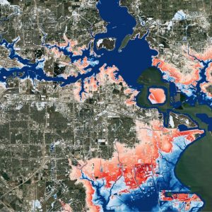
Flood depths

Flood depths and extents are critical to understanding the impact and severity of flooding for all three flood sub perils.
Risk Scores

Fathom’s flood data are now also available as Risk Scores. Offering a simple yet powerful way to compare the flood risk for assets across your portfolio. Available in two forms, Relative Risk and Risk Category, the metrics are designed to deliver a consistent method of understanding how flood risk varies from one location to another.
Quote Fathom’s flood hazard and risk data products are critical to assessing risks to Microsoft’s cloud infrastructure. In this way, their data impacts the delivery of services relied on by the 400 million global users of Office 365, Outlook.com and OneDrive, and the 48 million members of Xbox.
Quote Fathom’s most recent release – Fathom-Global 3.0 – provides flood maps for anywhere in the world, and at improved levels of detail, providing information to help decision makers better manage their future flood risk by considering climate change and the associated uncertainty.
Read Case Study
Quote
“Fathom’s data are super granular, which is something that our customers value a lot. You need that granularity to really understand how a flood will impact an asset.”
Quote Fathom provide a first-rate product and service based upon cutting-edge research and methodologies, which are both robust and transparent. Their flood data sets are global, consistent and high calibre. Most importantly, Fathom is a responsive and collaborative firm who consistently deliver.