Flash Flooding, Germany 2021


Post event response in the aftermath of the flash floods across Europe throughout July 2021
Event start
13th July 2021 (87 litres/m2 over western Germany)Date of forecast
12.7.2021Report issuing date
27th July 2021In July 2021, several countries across Europe experienced torrential rain causing devastating flash floods
The result was significant loss of life and damage to both property and infrastructure. This was felt hardest in Germany but areas within Belgium, Netherlands, Switzerland, and Luxembourg were also affected. As of 20th July, 165 deaths had been reported in Germany, 31 deaths in Belgium, and many people were still missing in Germany.
Situation summary
The severe flood event that affected several European countries in July 2021 led to loss of life and significant damage to property and infrastructure, particularly in Germany, but Belgium, Netherlands, Switzerland, and Luxembourg were also impacted. This report will give an overview of the weather conditions that drove the event and the resulting impacts on the hydrology of the affected regions. It will also put the event into context compared to normal climate conditions and historical flood events, and assess why this event was so severe.
What happened?
Weather
Between 12th to 15th July, a zone of low air pressure (named “Bernd”) was located over Central Europe, between areas of high pressure to the east and west, which prevented it from moving on. Warm air from the Mediterranean carrying large amounts of moisture interacted with the low pressure system which, in combination with low mountain ranges in the region (Sauerland, Westerwald and Eifel), forced this warm moist air to rise higher into the atmosphere where it cooled. This resulted in recurring or persistent heavy rain that covered large areas in Germany. Over the next few days until the 19th July, Bernd moved off towards Southeastern Europe, again coming into contact with hilly or mountainous topography (Ore Mountains, Lusation Mountains, Alps) leading to persistent heavy rainfall in eastern Saxony and southern Bavaria, Lusatia and the Berchtesgadener Land.
On the 13th July rainfall was mainly over the centre of Germany, with radar measurements suggesting up to 87 litres/m2 fell in the Ore Mountains (Marienberg region) in 2 hours. Over the 14th and early hours of the 15th July, heavy continuous rain fell over a large area of western Germany stretching from Dortmund down to Trier, with regionally more than 150 litres/m2 of precipitation being registered in 24 hours1.
Hydrology
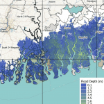
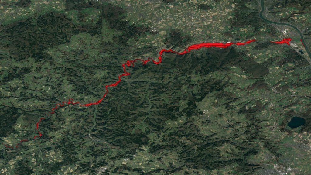
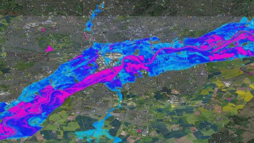
The heavy and prolonged rainfall resulted in severe flooding across Germany and several other countries, with North Rhineland-Westphalia, where 23 towns and districts reported flooding, and Rhineland-Palatinate being the worst affected German regions. Sections of large rivers such as the Rhine, Ruhr, and Moselle flooded, however significant damage was also caused by flooding of smaller rivers and tributaries such as the Erft (tributary of the Rhine), the Volme (Ruhr) and the Ahr (Rhine). The city of Hagen, for example, declared a state of emergency after the Volme burst its banks and experienced the worst flooding in 25 years. 1905 residents were evacuated from Erfstadt, a commuter town just south of Cologne, whilst Ahrweiler district and the spa town of Bad Neuenahr-Ahrweiler were heavily flooded by the Ahr. Flash floods and landslides occurred in small upper reaches and narrow valleys in Saxony and Berchtesgadener Land.
Impacts
Considerable damage occurred locally to the flooded rivers, with houses, buildings, cars, and bridges being swept away or damaged. Railway lines and roads were badly damaged and left unusable in places, and damage to sewage plants and water management infrastructure also occurred. There was concern that the Steinbach dam, to the south of Cologne, may break, resulting in 4500 people from the Rhein-Sieg district being evacuated. Oil pollution of rivers, including parts of the Rhine, and contamination of drinking water were also reported. As of 20th July, 165 deaths had been reported in Germany, 31 deaths in Belgium, and many people were still missing in Germany.
The German government is considering an aid package of approx €400m (£344m), whilst GDV, a trade body representing German insurers, has suggested that this may become the worst year for financial losses from severe weather since the 2013 floods, when insurers took a loss of €9.3bn2. Aon have estimated that the heavy rain and hail experienced in June may lead to $4.5bn in payouts from insurers, which would make it the costliest two-week stretch for Europe on record2.

Has this happened before?
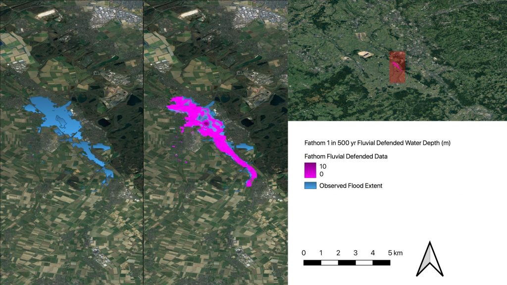
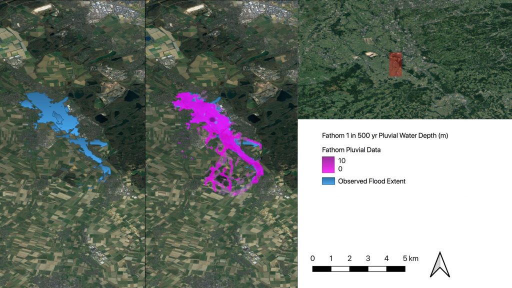
Severe floods were also experienced in Germany and other European countries in May/June 2013 and August 2002, resulting in billions of Euros of damage. One of the worst affected regions in Germany in the July 2021 event was the Rhineland-Palatinate state, with the River Ahr experiencing particularly destructive flooding. 2 of the 7 water level gauges located on the River Ahr, which are located upstream and downstream of the badly flooded town of Bad Neuenahr-Ahrweiler, suggest that the July 2021 event was significantly in excess of previously recorded high water level events at the gauges (the top ten ranked events extend back to 1999). The Bad Bodendorf gauge recorded a maximum water level of 483 cm on the 14th July 2021 , compared to the largest past event which had a maximum water level of 313 cm on the 2nd June 2016 (with a discharge of 233 m3s-1)4 , whilst the Altenahr gauge recorded a maximum water level of 575 cm on the 13th July 20213 or approximately 700 cm on the 15th , compared to the previous maximum of 371 cm on the 2nd June 2016 (with a discharge of 214 m3s-1)4.
From these data, it is not possible to determine a return period water level or discharge for the 2021 event. It may be that the historical time series data for these gauges would be available on request from the State Office for the Environment Rhineland-Palatinate, which would allow return periods to be determined. However, a spokesman for the German Meteorological Service was quoted to have said that an early, unpublished estimate by his service concluded that the flood may be a 1-in-500-year event5.
Why was this event so severe?
Environmental Conditions
Several factors came together to make this such a severe event, both in terms of the severity of the flooding event itself, as well as the impacts it had on communities.
As would be expected, the flood was partly the result of huge amounts of rain falling almost continuously over a large region, at high intensities meaning that the majority of it would become surface runoff rather than infiltrating the soil. Whilst the amount of precipitation wasn’t record breaking when considering Germany as a whole, the rainfall recorded at an unusually large number of stations in the west of the country exceeded previous records, and many of the rainfall events during the first few days had a return interval of 100 years or longer. In some regions, 1.5 to 2 times the average July rainfall, compared to a 1991-2020 reference period, fell over a few hours or days1.
However, the topographic conditions also increased the risk of flooding in many of the affected areas, with some of the surface runoff being channelled into narrow river valleys. Additionally, Germany had experienced recurring rainfall over the 3 weeks prior to the event, resulting in the soil in the worst affected regions already being at or close to saturation, limiting the amount of water being absorbed into the soil and leading to more surface runoff.
Flood warnings
Forecasts from 9th July onwards showed a high probability of flooding in the affected regions, with there being little doubt several days before that a major flood event was imminent. Alerts were issued to national and local authorities via the European Flood Awareness System (EFAS, part of the EU’s Copernicus Emergency Management Service) from 10th July6, with formal flood notifications being issued several days before the event to authorities in Germany, Belgium, Netherlands, Switzerland, and Luxembourg7, and regular updates being issued as predictions became more precise. Regional warnings of extremely high rainfall and flooding were also issued by the German Meteorological Service (DWD) and the Environment Agency in several German states6. Over 150 warnings were also issued to members of the public via apps and the media.
In some regions actions were taken following these warnings, including the erection of temporary flood defences, evacuations, moving vehicles to higher ground, and the lowering of water levels in dams as a precaution. However, in others either little or no action was taken, or warnings did not get through to the public or officials (for example, due to severed phone links), or they did not know how to respond. In general, authorities knew about the event several days in advance and had sufficient and accurate warnings (the scale and distribution of the floods match those that were forecast several days before6). The lack of preparations in some areas has been attributed to over dependence on digital alert systems, reluctance to order evacuations, and disbelief about the predicted disaster, as well as less detailed flooding information being available for smaller rivers and tributaries making flood prevention more difficult in these areas.
Climate change
Slow moving, very heavy rainfall systems such as this will become more likely as global average temperatures increase. A recent study8 from Newcastle University and the UK Met Office, for example, used climate models with a very high spatial resolution of 2 km to investigate the occurrence of these events under a worst-case warming scenario (Representative Concentration Pathway (RCP) 8.5). It was concluded that slow-moving storms could become 14 times more common over land by the end of this century8, suggesting that floods such as these could become more common in the future. A study into whether this event can be attributed to climate change is currently being prepared by the World Weather Attribution Project.
Sources
- https://www.dwd.de/DE/leistungen/besondereereignisse/niederschlag/20210721_bericht_starknieder schlaege_tief_bernd.pdf?__blob=publicationFile&v=6
- https://www.ft.com/content/66aa44bf-0c35-40be-9e02-b94881e8995c
- https://pegelalarm.at/paw/chart.html?commonid=auto-1004307
- https://www.hochwasser-rlp.de/rheinlandpfalz
- https://www.wsj.com/articles/germanys-opposition-politicians-blame-government-for-ignoring-floodwarnings-11626694101
- https://theconversation.com/europes-catastrophic-flooding-was-forecast-well-in-advance-what-wentso-wrong-164818
- https://theconversation.com/report-from-europes-flood-zone-researcher-calls-out-early-warningsystem-gridlock-amid-shocking-loss-of-life-164648
- https://agupubs.onlinelibrary.wiley.com/doi/full/10.1029/2020GL092361

More response reports