FABDEM+
A globally consistent and accurate digital elevation model
FABDEM+ offers a seamless blend of FABDEM and enhanced local data to provide high quality elevation information for every location in the world.
Comprising consistent elevation data and comprehensive metadata, it ensures access to highly accurate terrain information. Available at 1 arcsecond (~30 m) worldwide and up to 1/3 arcsecond (~10 m) in areas where we have enhanced data, its capability to provide ‘bare earth’ elevations makes it suitable for a wide range of use cases. These include the planning of linear assets, mapping natural perils, and creating artificial digital environments.
FABDEM+ key features
Coverage
LiDAR: 30+ countries, 10 million km².
FABDEM: Global excluding Greenland and Antarctica.
Digital terrain data
Removal of forests and buildings to represent bare earth elevation data using peer-reviewed and openly published methods.
Metadata
Information on native resolution, date of capture, source data type and certainty rank to provide full transparency.
Resolution
—~30 m (1 arcsecond) global
—~10 m (⅓ arcsecond) data available for areas with enhanced data, including the US
Validation
Underpinned by FABDEM which has been independently validated and was ranked as the best-in-class global digital terrain dataset in two separate studies.
Access
Available via API, Fathom Portal, on premise or via a partner.
Explore our new world-leading global terrain data – FathomDEM+
Next-generation global terrain dataset designed to provide a single, uniform and independently benchmarked view of terrain worldwide.
Combining bespoke machine-learning techniques with the world’s largest curated collection of LiDAR, FathomDEM+ delivers near-LiDAR-quality elevation data globally.
What is FABDEM?
FABDEM (Forest And Buildings removed Copernicus DEM) was the first global digital elevation model (DEM) with forests and buildings removed at a 30-meter resolution. The data uses a correction algorithm to remove biases within the Copernicus GLO 30 Digital Surface Model (DSM) that arise from the presence of objects on the Earth’s surface.
The dataset allows users to model natural hazards globally with more detail than ever before. It has numerous practical real-world uses, enabling professionals to understand flood risk or any terrain-related project on a global scale or in data-scarce regions. It is used by engineers, hydrologists, government, and international firms.
Built in tandem with the University of Bristol, the data is available at 1 arc-second grid spacing (approximately 30m at the equator) across the globe. This data is ideal for professionals needing to understand flood risk on a global scale or in data-scarce regions of the world.
About FABDEM+
FABDEM+ combines FABDEM and local high resolution terrain data. It is a seamlessly blended digital terrain model that combines thousands of data sources into one cohesive product.
FABDEM+ offers users consistent elevation data, enriched with an additional layer of information, Metadata, to ensure access to the most recent terrain information.
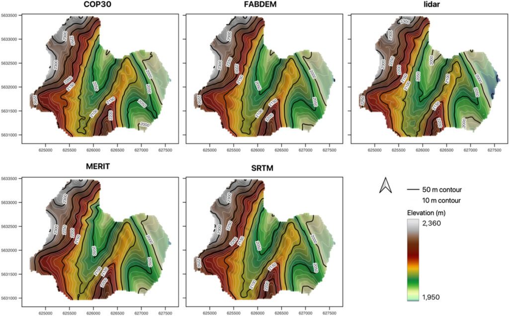
This multi-source data provides a single source of information for those who need to define ground elevations, anywhere in the world. Validation published in Environmental Research Communications showed the data underpinning FABDEM is more accurate than the other available global DEMs at the time. Further validation was conducted by independent scientists in 2023, who ranked FABDEM as the best 1 arcsecond global DEM.
FABDEM’s finer spatial resolution allow smaller topographic features such as narrow flow pathways to be represented, making it a critical component within GIS, digital twin projects, engineering, infrastructure planning, modeling natural perils and earthworks.
Setting a new benchmark in terrain data – FathomDEM+
In 2026, Fathom released FathomDEM+, our latest global terrain dataset. FathomDEM was independently validated and published in remote sensing journal as the best global DEM.
Learn more about how Fathom approaches terrain processing and terrain data by exploring our interactive product stack
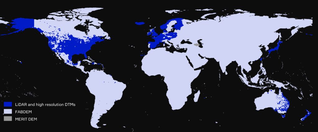
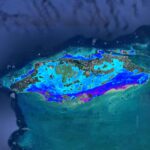
Coverage of FABDEM+ globally
By combining FABDEM with available LiDAR, Fathom offers the entire world at 30 meter resolution, with 10 meter resolution data available in regions where enhanced data exists.
Over 30 countries benefit from LiDAR within the digital terrain model (DTM), though at varying degrees of coverage. In total LiDAR comprises over 10 million km². Where LiDAR is unavailable, FABDEM fills in the gaps.
LiDAR is focused in regions of high population and covers more than 90% of the population in many countries including Hong Kong, Japan and New Zealand.
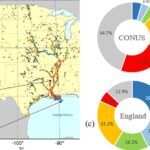
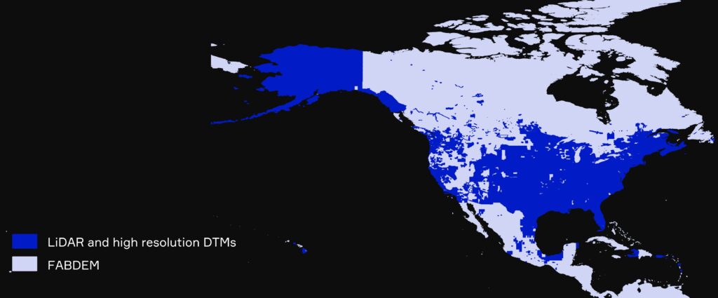
Coverage of FABDEM+ in North America
LiDAR available within FABDEM+ covers 90% of the population in US and Canada.
For the US specifically, 79% of lower land area is covered by LiDAR, which includes 94% of buildings.
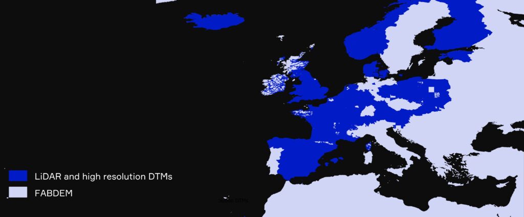
Coverage of FABDEM+ in Europe
FABDEM+ comprises enhanced LiDAR data for >20 European countries.
Across the countries represented, LiDAR covers ~90% of the total population.
Where LiDAR is unavailable, Fathom uses data from its digital terrain model, FABDEM.
Accessing FABDEM+

Fathom API
Gain seamless access to Fathom’s entire Global Terrain Data or select a specific region using our cloud-based API.

Fathom Portal
Visualize the data via Fathom’s interactive in-house platform. If you are interested in this solution, you can trial the platform using Fathom sample data for free. Request a demo here.

Direct provision
Integrate your terrain data with your internal systems and host the data on-site, through the provision of GeoTIFF files.

Partner
Fathom’s data can seamlessly integrate with a wide range of third party platforms. Get in touch to enquire about a platform or learn more about our existing partners here.
Related products
Recent research
Introducing BURGER, Fathom’s new extreme rainfall dataset

Flooding is not like filling a bath
Exposure to flooding in Small Island Developing States (SIDS)
A 30 m global flood inundation model for any climate scenario
Hyper-resolution PCR-GLOBWB: opportunities and challenges from refining model spatial resolution to 1 km over the European continent
Flood defense standard estimation using machine learning