
The Nature Conservancy
Fathom’s large-scale flood-hazard model enabled The Nature Conservancy to assess natural flood defences across the Mississippi River Basin.
The problem Flooding in the US is worsening under climate change, accelerating damage to infrastructure and displacing significant numbers of people from their homes
In the next three decades, greater rainfall and higher sea levels could push up the national annual cost of flood damages by over $8 billion to $40.6 billion, Fathom-led research predicts.
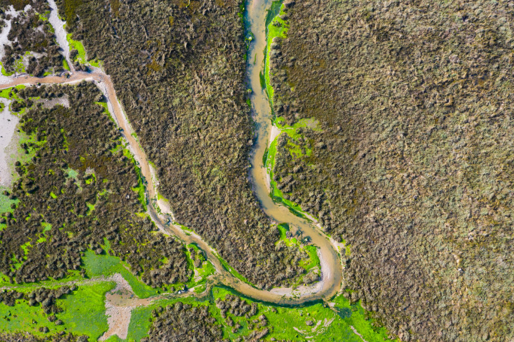
Government authorities and land planners are increasingly looking for nature-based solutions to this pressing problem. Floodplains—in their natural form —are a prime example of such a solution. When rivers overflow, undeveloped floodplains help hold the water back from communities and infrastructure. This takes pressure off floodwalls and levees. Just one acre of wetlands can hold about 1 million gallons of water—more than an Olympic-size swimming pool.
Yet floodplains are increasingly being converted to farmland or built upon as populations grow and land for infrastructure falls into ever-shorter supply elsewhere. These changes in land use diminish the many benefits that floodplains deliver.
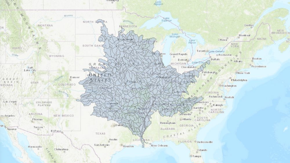
In 2019, The Nature Conservancy (TNC), a global organization working to conserve land and water, launched the interactive Floodplain Prioritization Tool. This free online resource helps government authorities, planners and landowners identify which floodplain sites in the Mississippi River Basin to prioritize for either protection or restoration. This is a significant challenge with tens of millions of acres of floodplains across the Basin having been developed on prior.
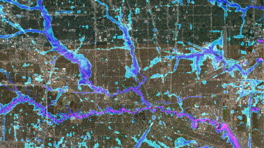
In building the Tool, TNC required detailed maps of Mississippi floodplains’ characteristics, including their flood risk, to guide conservation decisions. But existing flood data from FEMA are patchy and significantly underestimate the risk of flooding rivers across the US (Read about their collaborative research with Fathom here).
TNC needed detailed, reliable data at a large scale to enable decision-makers to identify the most valuable sites within the vast expanses of the Mississippi River Basin and support effective allocation of resource.
The solution TNC used a bespoke, large-scale model developed by Fathom to assess flood risk across the Mississippi River Basin for the tool
Fathom’s US Flood Map gave not only offered the detail, scale and reliability that they needed, but also provided a more realistic picture of how floods physically spread than the majority of existing large-scale models.
The map covers the entire contiguous US and is more comprehensive than FEMA’s flood data, which have notably poor coverage of smaller catchments and streams. It combines fluvial (river) data, including for small streams, with pluvial (rain), elevation and flood defence data, and produces maps for three frequencies: 1-in-5, 1-in-100 and 1-in-500 years. These floods have a 20%, 1% and 0.2% chance, respectively, of occurring in any given year.
Read more about the model in this academic study.
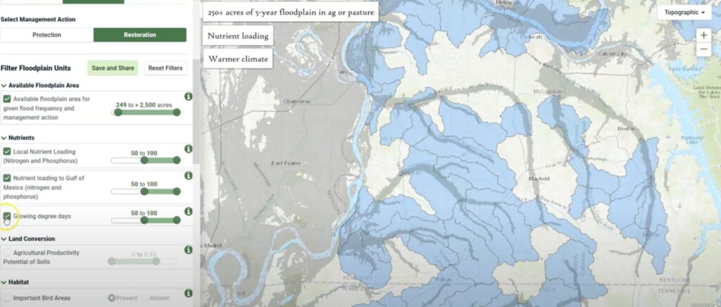
The results The Floodplain Prioritization Tool is an interactive map that allows users to view floodplain sites found across 24 US States within the Basin
Users can filter floodplain sites based on flood frequency, their size, predicted flood damages to property, and the local population’s size.
To get a comprehensive picture of floodplains’ value, or find sites according to specific features, users can also pick out sites according to a much wider range of characteristics. These include features relating to their ecological value for wildlife and whether they release nitrogen and phosphorus pollution into the Gulf of Mexico.
Users can also search for sites according to their social vulnerability. This describes how well a community can cope with flooding based on demographic factors, such as income.
The Floodplain Prioritization Tool has already been put to use. It is helping inform a collaborative floodplain management plan for Missouri’s Lower Meramec River, led by the US Army Corps of Engineers’ Silver Jackets program.
Potential FP tool users
Potential applications
Local governments
Development of watershed plans for water quality, e.g. 9 Key Element Plans; siting of natural infrastructure projects.
Land trusts
Strategic conservation planning; prioritizing projects; grant proposals; wetland education and outreach.
Compensatory Mitigation Project Sponsors/Wetland Regulators
Identify and analyze potential restoration sites; guide project selection; support mitigation goals and improve outcomes.
County Planners/Regional Planning Commissions
Aid in developing local and regional comprehensive plans; parks and open space plans; flood control and water quality improvements.
Private businesses
Wetland restoration as one component of meeting regulatory requirements, e.g. water quality trading and Adaptive Management programs.
Wetland consultants
Wetland restoration planning and design.
Watershed planners
Watershed assessments, water quality planning.
Nutrient Management Specialists
Nutrient management planning.
Wildlife / other resources managers
Prioritize projects; identify and analyze sites; wetland restoration planning and design.
Agricultural producers
Nutrient management planning; habitat improvement.
Lake associations
Lake management plans; shoreline protection; water quality improvement; education and outreach.
Universities / university extensions
Wetland research; education and outreach; economic valuation of wetland ecosystem services.
Table taken from: Who is it for? | Freshwater Network – The Nature Conservancy
Protecting floodplains as a nature-based solution will pay dividends. TNC reports that restoring the 100-year flood zone of the five-state Upper Mississippi River Basin could store 39 million acre-feet of floodwaters—the same volume that caused the Great Flood of 1993—and save over $16 billion in flood damage costs.
Joint research by Fathom and TNC indicates that every $1 invested in conserving large 100-year floodplains in the US could save at least $5 in the long term by avoiding future flood damage.
Related case studies
Texas Water Development Board
Texas Water Development Board uses Fathom data, and others, to accelerate the development of the first statewide flood planning program in the absence of publicly available flood data.
Arup & World Bank
Fathom & Arup demonstrate how rapid, data-driven flood modeling can quantify the impact of urban greening on flood extent, soil erosion, and urban heat. Discover how NBS can create more resilient cities.


Bank of England
Fathom supported the Bank of England in their analysis of submissions for CBES 2021 using the Fathom-UK CAT model.
Quote We would like to express our gratitude to both the physical risk open data providers as well as to the plethora of technical experts for all of their contributions to this exercise over the past two years.

Canopius
Global (re)insurer, Canopius, used Fathom-US flood hazard data to quantify their exposure to flooding to inform pricing and facilitate exposure management.