
Mapping statewide flood vulnerability in Florida
Fathom fills the data gap to enable a statutorily required statewide flood vulnerability assessment as part of Florida’s Statewide Flooding and Sea Level Rise Resilience Plan
Thanks to its tropical and subtropical climate, coastal location and flat topography, Florida is susceptible to hurricanes and flooding and, as conditions change over time, the risk is expected to grow. To build Florida’s resilience, an ‘Always Ready Bill’ was signed into law in May 2021 and three months later the Resilient Florida Program was established.
As part of the program the Florida Department of Environmental Protection (FDEP) was charged with conducting a statewide flood vulnerability assessment to identify the areas, infrastructure and communities that are at risk of flooding and the impacts of sea-level rise. The flood risk analysis needed to:
- Include an inventory of critical assets
- Determine the depth of flooding for each asset and assess the impact of flooding (high, medium or low)
- Consider coastal and inland flood risks in 2040 and 2070
- Be based on the latest statewide LiDAR data
- Be completed within an aggressive timeline
Short timeframe, large data gaps
FDEP joined forces with Fathom and two local engineering firms, Taylor Engineering and Jones Edmunds, to complete the mandatory flood vulnerability assessment by the time the project was ready to launch.
First, they needed data, some of which was already available. FDEP had created a database of critical assets with more than 3 million data points including roads, rail networks, government buildings, critical infrastructure, and natural and cultural resources.
The National Oceanic and Atmospheric Administration (NOAA) had data on sea-level rise projections, while published flood hazard data was available from the Federal Emergency Management Agency (FEMA), the United States Geographical Survey (USGS) and Flood Hub. However, there were large gaps in data coverage across the state and the flood datasets were not compatible and lacked the necessary future conditions.
What the team needed was a consistent, seamless, statewide view of flood hazard for pluvial, fluvial and coastal flooding, for both current and future conditions.
Fathom, in partnership with the local engineering firms, was able to develop a bespoke statewide perspective of flood risk under current and future scenarios to provide a complete picture of flood risk in Florida.
Collaborating for a comprehensive view of risk
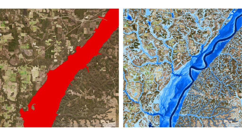
Fathom has extensive experience of LiDAR-based 2D flood-modeling in the US. Its climate-driven US Flood Map covers inland and coastal flooding over the whole of the continental US, with Fathom’s cutting-edge FABDEM data filling any gaps in LiDAR coverage. Crucially, Fathom provides a series of future views up to 2100 under any known emission scenario.
Having worked with the Texas Water Development Board on a similar project in 2019, Fathom came on board to develop three separate models for pluvial, fluvial and coastal flooding in Florida, for the time horizons of 2040 and 2070.
This isn’t the first time that Fathom’s data have been used to supplement local data to build a complete statewide flood map.
Fathom partnered with local firms and the Texas Water Development Board to accelerate the development of the first statewide flood planning program.
Bespoke modeling and validation
To achieve a truly local understanding of flood risk, Fathom worked with Jones Edmunds to adapt its models to represent the specific nature of flood events in Florida. Modifications to Fathom’s modeling framework included:
- Updating its design storm events to 1-day and 7-day durations
- Using local soil maps to account for run-off being generated both by rainfall infiltration and by saturation due to the high water table
- Incorporating NOAA’s impervious mapping data
- Using change factors provided by the USGS
- Working with the state’s Chief Resilience Officer to align future climate scenarios to RCP 4.5, in line with proposed new legislation
Once these models were developed, the next step was to validate them. Jones Edmunds compared Fathom’s data to both FEMA and locally derived city and county flood maps. Then Taylor Engineering and Jones Edmunds took Fathom’s flood hazard data and mapped it over the critical assets data to determine the depth of flooding and its impact for each asset.


Critical data for future planning
For the first time, FDEP now had a comprehensive picture of the flood risk to assets, infrastructure and communities across Florida. The team were able to conduct a sensitivity and vulnerability analysis for each of the 67 counties in line with the stringent requirements – and all within the short timeframe.
The data can also be represented via a dashboard, which FDEP can use internally to assess the flood risk of any asset type, in any county, and in any flood scenario.
Ultimately, the vulnerability analysis will inform future planning, enabling the state government to enhance flood resilience for Florida.

Collaborating for success: Mapping statewide flood vulnerability to achieve Florida’s legislative mandate
Watch the webinar on-demand below to explore:
- The reasons driving the creation of consistent and comprehensive statewide mapping with future climate scenarios.
- The challenges encountered when developing a map of such complexity and the innovative solutions created to overcome them.
- How Fathom’s data can supplement Base Level Engineering maps, local data and the latest LiDAR data to to fill in the data gaps across the US.
- How to demonstrate the benefits delivered to a wide range of stakeholders.

Get a full view of flood risk in Florida

Quote Fathom provides a much-improved resolution of flood risk mapping. This helped us identify significantly more critical assets that were at risk compared to that shown using FEMA maps and created a more localized understanding of flood risk.
Read Case Study
Quote I knew it was going to be a challenge to create a comprehensive statewide vulnerability assessment using a seamless data set that had both existing and future conditions. We saw that Fathom had carried out similar work in Texas, so we were confident Fathom’s data was comprehensive and robust.
Read Case StudyTake the next step to understand how the shift in US flood data is reshaping risk insights
As public datasets evolve and private models play a larger role, discover how hybrid approaches are redefining flood risk intelligence and what that means for decision-making going forward.
Related case studies


AXA: a cutting-edge catastrophe model for Europe
Learn how Fathom and AXA built a state-of-the-art catastrophe model that strengthens AXA’s financial resilience and regulatory reporting.


Arup & World Bank
Fathom & Arup demonstrate how rapid, data-driven flood modeling can quantify the impact of urban greening on flood extent, soil erosion, and urban heat. Discover how NBS can create more resilient cities.

Texas Water Development Board
Texas Water Development Board uses Fathom data, and others, to accelerate the development of the first statewide flood planning program in the absence of publicly available flood data.


FEMA’s Risk Rating 2.0
Fathom provided FEMA with a more accurate, up-to-date picture of US flood risk which informed how the NFIP prices insurance, using Fathom-US flood map.