-

-
-
Hawker, L.,
-
-
-
-
Saoulis, A.,
-
-


An accurate representation of the Earth’s terrain is key for many sectors, from engineering to ecology. Existing global digital elevation models (DEMs) are widely used across industries, though these come with limitations, often a result of systematic biases caused by trees, buildings and instrumentation error.
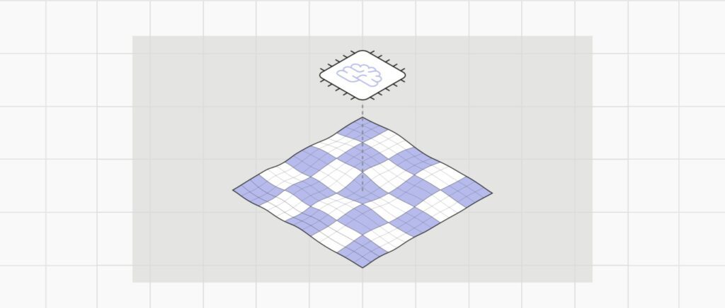
A new research paper published in Environmental Research Letters outlines the creation of FathomDEM, a new global 30 m DEM produced using a novel machine-learning approach. It relies on a hybrid vision transformer approach, i.e. ‘computer vision’ to analyse the errors within Copernicus DEM (henceforth COPDEM) to create a new DEM more closely aligned with true topography i.e. bare earth.
The result is a global DEM with impressive capacity to perform across multiple landscapes and terrain types. And when tested on the downstream tasks of flood modeling, FathomDEM shows increased accuracy over the DEMs currently ranked as ‘best’ and even approaches the performance of LiDAR-based flood modeling.
FathomDEM+ now available
Introducing FathomDEM+ next-generation global terrain dataset designed to provide a single, uniform and independently benchmarked view of terrain worldwide. Combining FathomDEM with the world’s largest curated collection of LiDAR and other high-resolution datasets spanning over 10m km2.
Why use a digital elevation model (DEM)?
Digital elevation models (DEMs) are vital inputs for a wide range of applications including (but not limited to) demography, infrastructure planning, ecology, geomorphology, glaciology, natural hazard modeling and volcanology. They enable us to relate theoretical relationships, such as the flow of water or the migration of people, to a representation of the real world landscape.
DEMS exist at the global – or near-global – scale at 1 arc second, which equates to ~30 m resolution. Numerous studies have been published investigating which DEM is the ‘best’, be that for a specific application or for certain landscape types.
A recent comprehensive analysis by Bielski et al. provides a novel approach for ranking DEM by assessing numerous locations around the globe. Overall, the research determined that COPDEM is the best digital surface model (DSM), while Fathom’s FABDEM is the best digital terrain model (DTM). The paper even recommended that a number of other DEMs are not suitable for use due to their inferiority.
Following the publication of this FathomDEM paper, researchers Guth et. al (2005), published a study benchmarking six global DEMs and found that FathomDEM consistently performed best.
Fathom’s new world-leading global terrain dataset – FathomDEM+, a combination of validated FathomDEM base and the largest collection of LiDAR and other high-resolution data is now available. Learn more about FathomDEM+ >
Method
FathomDEM was produced using state-of-the-art hybrid vision transformer/CNN (convolutional neural network) model to remove a significant amount of height biases from COPDEM. Crucially, this approach relies on context; using spatial correlations as an inductive bias. It was employed within a UNet architecture and performed pixel-wise regression to predict a grid of correction values. The results were then validated against reference data and compared with other DEMs across a suite of landscape types.
First, the model was trained on geographic regions where high-quality LiDAR data is available, with iterative updates of the model until the predictions matched the necessary DSM to DTM corrections. The trained model was then used to predict for the full globe, including areas where no reference data was available. In tandem, individual predictions were blended together in post-processing to create a global DEM.
Here are the key steps undertaken to generate FathomDEM:
a) Training: the neural network learns to generate predictions which match the ground truth data (LiDAR DTMs).
b) Prediction: global predictor datasets are fed through the neural network to generate (overlapping) patches of the corrected DEM. These are blended to generate the final DEM.
c) The neural network: predictor data flows through a U-shaped path, passing through a downsampling encoder then through an upsampling decoder. Skip connections between corresponding encoder and decoder layers preserve spatial information. Conv blocks represent a simple sequence of one or more convolutions, while the MaxViT blocks represent the encoder operations at a given resolution level.

How does this differ from the FABDEM approach?
Put simply, FABDEM was created using a pixel-by-pixel correction, predicted by a random forest regression model, using multiple predictors and a LiDAR target. While performing well, the individual pixel predictions can be less spatially continuous because it doesn’t bring ‘context’ of the surrounding landscape into the equation. FathomDEM instead uses 2D spatial information as an inductive basis. This means it simultaneously predicts the necessary COPDEM correction for an entire region by considering the spatial correlations across predictors. This is also known as ‘computer vision.’
FathomDEM key findings:
- Improved accuracy: FathomDEM surpasses existing global DEMs including FABDEM and COPDEM, which research finds the ‘best’ DTM and DSM respectively to date.
- Novel methodology: FathomDEM employs a hybrid vision transformer model within U-Net architecture; a combination which allows for both local and global feature extraction, leading to more robust and spatially coherent corrections.
- Extensive training data: The model was trained on a diverse and representative dataset of LiDAR, covering various landscape types to ensure global applicability.
- Outperforms more specialist DEMs: When compared with DEMs built specifically to predict elevation in low-lying coastal zones, FathomDEM shows the lowest errors overall.
- Validated for flood modeling: The improved terrain representation in FathomDEM translates to increased accuracy in flood inundation modeling, achieving comparable results to LiDAR.

Applying FathomDEM to flood modeling
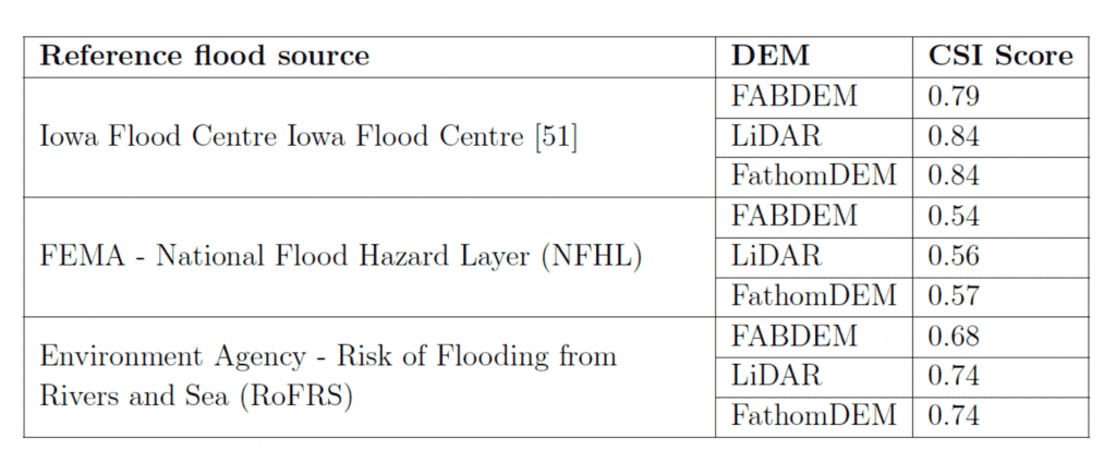
DEMs are an important input to flood inundation mapping; how can you determine flow paths without an accurate representation of the terrain? To measure the applicability of FathomDEM, it was used in Fathom’s Global Flood Map and the results analyzed against three reference flood maps. The results were then evaluated against variants using FABDEM and LiDAR.
To measure the results, the scientists used the critical success index (CSI), which provides a ratio of true positives, false negatives and false positives, with a perfect match scoring 1.0. A true match is not the aim due to differences in model set up, assumptions and inherent errors in the source data, and therefore a score of 0.7 to 0.9 would denote a well performing model.
In each of the reference datasets, the FathomDEM based models show very similar results to the LiDAR DEM and better results than FABDEM. This gives us high confidence that FathomDEM provides an improved representation of actual terrain features.
This new research offers a state-of-the-art approach to digital elevation modeling, thanks to the use of novel machine learning techniques. After extensive validation, the research team has shown FathomDEM is a clear improvement on FABDEM, and even on domain-specific DEMs such as those covering coastline like DeltaDTM.
Likewise, when FathomDEM is applied to a flood inundation model, its skill is of similar quality to LiDAR-derived flood inundation maps and a clear improvement on FABDEM. This shows the utility of FathomDEM, and there are many other applications where FathomDEM has the potential to make improvements, from scientific models to remote surveys and infrastructure planning.
For those in the scientific community, FathomDEM is available under a CC BY-NC-SA licence through Zenodo. Fathom’s newest global terrain dataset, FathomDEM+, combining FathomDEM with the largest collection of LiDAR and other high-resolution data is now available for license.