-

-
-
-
-
Johnson, K.,
-
Erickson, T.


The first peer-reviewed validation of a continental-scale, high-resolution flood hazard model; this paper won the prestigious AGU Editors’ Choice Award in 2018.
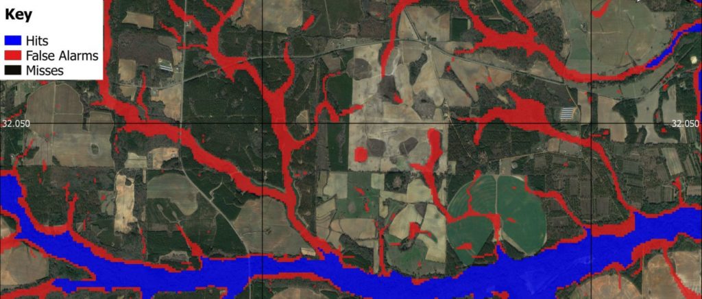
This paper reports the development of a ∼30 m resolution two-dimensional hydrodynamic model of the conterminous U.S. using only publicly available data.
The model employs a highly efficient numerical solution of the local inertial form of the shallow water equations which simulates fluvial flooding in catchments down to 50 km2 and pluvial flooding in all catchments. Importantly, we use the U.S. Geological Survey (USGS) National Elevation Dataset to determine topography; the U.S. Army Corps of Engineers National Levee Database to explicitly represent known flood defenses; and global regionalized flood frequency analysis to characterize return period flows and rainfalls. We validate these simulations against the complete catalogue of Federal Emergency Management Agency (FEMA) Special Flood Hazard Area (SFHA) maps and detailed local hydraulic models developed by the USGS. Where the FEMA SFHAs are based on high-quality local models, the continental-scale model attains a hit rate of 86%. This correspondence improves in temperate areas and for basins above 400 km2. Against the higher quality USGS data, the average hit rate reaches 92% for the 1 in 100 year flood, and 90% for all flood return periods. Given typical hydraulic modeling uncertainties in the FEMA maps and USGS model outputs (e.g., errors in estimating return period flows), it is probable that the continental-scale model can replicate both to within error. The results show that continental-scale models may now offer sufficient rigor to inform some decision-making needs with dramatically lower cost and greater coverage than approaches based on a patchwork of local studies.