
Flood risk assessment for renewable energy development
Renewable energy provider EDF power solutions North America integrates Fathom’s data into its GIS systems to accelerate site-screening and early-stage development
EDF power solutions North America is a leading renewable energy producer and service provider, delivering low-carbon energy projects such as wind and solar farms, storage, EV charging, hydrogen and microgrids. Since 1987, the company has developed more than 23 GW over 300+ projects across the US, Canada and Mexico.
The company’s GIS team is responsible for the spatial analysis of utility- and distribution-scale wind and solar projects across North America, working on projects from development, land acquisition and permitting to implementation, construction and operation.

The challenge
Identifying flood hazard at the start
Flooding is a significant concern for renewable energy projects, and often a hidden hazard due to gaps in existing publicly available flood data. Wind farms sited in low-lying, flood-prone areas risk structural damage to the turbines’ concrete foundations, for example. Solar projects can encounter drainage problems and, as drainage systems can be altered during construction, this must be taken into consideration from the outset. Access is another major issue – roads must stay usable so operations teams can reach the sites at all times.
Having experienced costly flooding at some of its projects in the past, EDF power solutions is working to ensure flood risk is identified as early as possible. The EDF power solutions team begins the process with greenfielding – analyzing a multitude of potential sites and identifying which ones are feasible and which ones could present challenges, such as flooding.
Quick flood assessment at this stage means the team can not only identify suitable sites, but also any areas within a selected site that might present problems.
To analyze flood risk across multiple project sites, EDF power solutions utilizes FEMA floodplain maps, the National Wetlands Inventory and the National Hydrologic Dataset, as well as in-house elevation analysis. However, these datasets do not offer consistent coverage of North America and bespoke analysis across multiple sites can be slow and expensive.
What EDF power solutions needed was reliable, nationwide flood risk data to identify “hidden hazards” in project sites early, before commissioning costly site-specific hydrological studies.
The solution
Nationwide flood data with local-scale precision
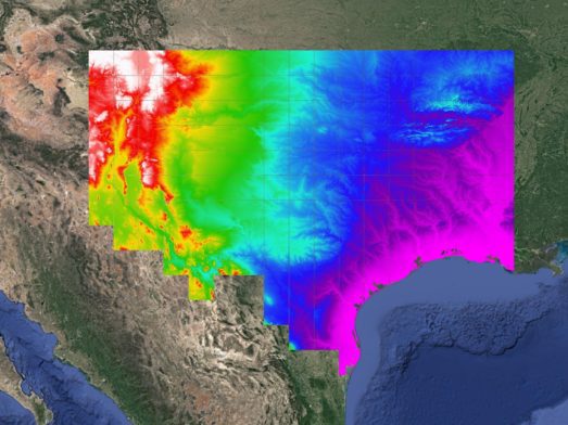
To support these preliminary analyses, EDF power solutions licensed Fathom’s US Flood Map; inland pluvial and fluvial, 10m resolution flood data for multiple return periods (intensity & frequency).
To ensure the data was fit for purpose, the team carried out an extensive evaluation. They first compared Fathom’s data against the results of their own detailed site-specific hydrological studies and then conducted an in-depth review of Fathom’s methodology.
“Our confidence in the data came not only from seeing the results compared to our hydro studies, but also from being able to access and understand the methodology.”
Rachel Clement, Director of GIS at EDF power solutions North America
The GIS and engineering teams worked together to identify which datasets best supported their requirements and then set depth thresholds (e.g. >3 ft). The datasets were then integrated into EDF power solutions’ GIS platform along with FEMA and other data. The team was then able to exclude any unsuitable sites and develop a nationwide “buildable land” dataset.


The results
Seamless integration for faster renewable energy site-screening
Fathom’s data was seamlessly incorporated into EDF power solutions’ existing GIS workflow to provide a centralized, single source of truth that can be used by multiple teams to collaboratively analyze flood risks.
It provides a trusted, holistic view of flood risk in an ‘off-the-shelf’ capacity, helping to speed up site-screening and reduce wasted time and budget on high-risk sites.
By screening out higher-risk sites early, the team could focus on the other challenges and risks that can arise across projects, and EDF power solutions is now exploring new ways to leverage Fathom’s data within other areas of the business.
“Fathom’s flood depth data has empowered EDF power solutions’ greenfielding teams to make more informed, data-driven decisions regarding site selection, land acquisition, and constraints analysis for early-stage projects. This valuable dataset not only accelerates our decision-making process but also improves the outcomes by driving us to pursue project areas with lower risk.”
Rachel Clement, Director of GIS, EDF Power Solutions, North America

Discover the most complete and technologically advanced flood map for the United States
Fathom is a global leader in flood and climate risk, providing subsecond access to the most complete and technologically advanced flood map for the US for infrastructure planning, risk assessments and long-term resilience.
Streamline planning, reduce costs and increase project efficiency across:
- Site assessment and selection
- Managing linear assets
- Critical infrastructure management
- Climate vulnerability assessments
- Statewide flood management planning
- Funding applications
Quote Fathom’s flood depth data has empowered EDF power solutions’ greenfielding teams to make more informed, data-driven decisions regarding site selection, land acquisition and constraints analysis for early-stage projects.
Quote This valuable dataset not only accelerates our decision-making process but also improves the outcomes by driving us to pursue project areas with lower risk.
Related case studies

AXA: a cutting-edge catastrophe model for Europe
Learn how Fathom and AXA built a state-of-the-art catastrophe model that strengthens AXA’s financial resilience and regulatory reporting.
Arup & World Bank
Fathom & Arup demonstrate how rapid, data-driven flood modeling can quantify the impact of urban greening on flood extent, soil erosion, and urban heat. Discover how NBS can create more resilient cities.
Texas Water Development Board
Texas Water Development Board uses Fathom data, and others, to accelerate the development of the first statewide flood planning program in the absence of publicly available flood data.

FEMA’s Risk Rating 2.0
Fathom provided FEMA with a more accurate, up-to-date picture of US flood risk which informed how the NFIP prices insurance, using Fathom-US flood map.