Researchers have introduced a first-of-its-kind hyper-resolution global hydrological model, an essential tool for managing water resources.
Accurately simulating and predicting the distribution, abundance and scarcity of water is crucial for managing the world’s precious water resources. To do this, policymakers and other stakeholders rely on global hydrological models.
However, a criticism of these global models is that their spatial resolution is not high enough to help inform water management decisions at a local level. The push to increase their spatial resolution to the (sub-)kilometer scale has been described as one of hydrology’s “grand challenges”.
There have historically been two major hurdles to achieving this – a lack of high-resolution meteorological data and high computational costs of running these models at a high spatial resolution.
Despite notable advancements in the development of hyper-resolution hydrological models, their application has so far been limited to continental scales. But now, the authors of this new research paper have introduced a hyper-resolution model that, for the first time, provides truly global coverage.
The research: Enhancing global hydrological model PCR-GLOBWB
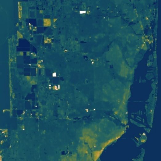
The primary objective of the study was to establish a first-of-its-kind global hyper-resolution hydrological model that spans a multiple-decade period (1985–2019). The researchers focused on these key areas:
The team developed a new procedure to downscale meteorological data to a commensurate spatial resolution. This integrates high-resolution topographic and climatic data, allowing for a more nuanced and detailed representation of hydrological processes at finer spatial scales.
The hydrological model PCR-GLOBWB, traditionally used for large-scale simulations, was enhanced with a new parallelization approach. This splits large, computationally expensive, river catchments into smaller units and solves them in a hierarchical manner from upstream to downstream.
The model includes a snow module for simulating glacier-like lateral movement of frozen water at higher resolutions.
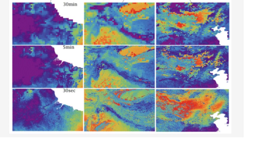
The team conducted a global hydrological simulation at a 30 arcsec resolution and compared it to previous simulations at coarser resolutions (5 and 30 arcmin). The comparison uses observational data for river discharge, snow cover extent, soil moisture content, land surface evaporation rates and groundwater storage levels.
The results: An advancement in hydrological modeling
The research represents a significant step forward in hydrological modeling, potentially helping us to better understand and manage water resources at both the local and global levels. There were three key findings:
Hyper-resolution modeling leads to more accurate river discharge simulations, especially for smaller, often upstream, catchments.
Global hyper-resolution modeling is possible with current computational resources and that hyper-resolution modeling results in a better match with in-situ observations and more recently released high-resolution remote-sensing products.
Global hydrological modeling still needs to incorporate land cover heterogeneity and relevant hydrological processes at the (sub-)kilometer scale to provide more accurate estimates of soil moisture and evaporation fluxes.
Read the original research in detail
Related research
A high-resolution global flood hazard model
This paper describes the architecture of our Global Flood Model and validating its performance against local data.
Hyper-resolution PCR-GLOBWB: opportunities and challenges from refining model spatial resolution to 1 km over the European continent
For the first time, researchers have applied the global hydrological model (GHM) PCR-GLOBWB at 1 km spatial resolution over the entire European continent.
A 30 m global flood inundation model for any climate scenario
New techniques to simulate the behaviour of floods, which are then validated against a series of benchmarks to reveal unprecedented levels of model fidelity.
A 30 m global map of elevation with forests and buildings removed
This work signifies one of the biggest step-changes in global flood modelling capabilities since the advent of the field.
A high‐accuracy map of global terrain elevations
A significant set of systematic improvements to the SRTM terrain dataset produced by a project led by our colleague in Japan, Dai Yamazaki.
Optimal use of high-resolution topographic data in flood inundation models
A paper describing the assimilation of high resolution topography into 2D flood models.