Engineering flood resilience
Subsecond access to global flood risk data for infrastructure
planning, risk assessments and long-term resilience


Identifying and mitigating the potential impact of physical risks, such as present and future flooding, is essential for ensuring the successful delivery of infrastructure projects and enhancing long-term climate resilience.
Yet, engineers still face significant challenges in accessing credible, consistent, broadscale flood and climate risk data at all stages of the infrastructure lifecycle.
Fathom overcomes these challenges with global flood and climate data, enabling engineers, climate specialists and GIS analysts to rapidly access, analyse and make more informed decisions based on scientifically robust data earlier in any project. As a leading provider of award-winning flood data, we support AEC organizations, asset owners, climate specialists and digital engineers to embed meaningful risk governance within engineering practices. With global coverage, Fathom helps engineers in:
Project delivery and stakeholder engagement
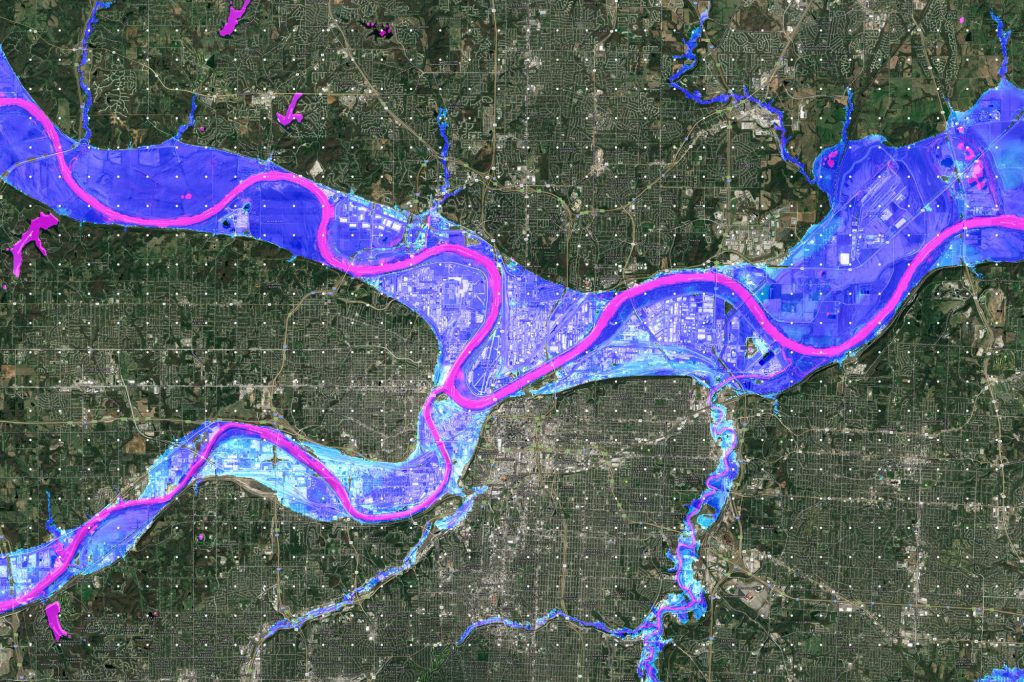
Make timely, early-stage decisions using Fathom data.Fathom current and future flood hazard data supports more informed decisions in the earlier stages of a project to help shape what-if scenarios, site selection, design and funding alternatives and more appropriate allocation of resources for project delivery. The easy access to Fathom data provides a consistent and broadscale understanding of flood risk and so significantly reduces time and costs for sourcing and modelling data for the initial project decisions.
Climate risk assessment and management
Conduct flood and climate risk assessments to understand the current and future flood risk of any assets or infrastructure globally.
Linear assets such as rail, highway or utility networks are particularly suited to using Fathom data.
Fathom’s future flood scenarios can be used to identify critical assets and infrastructure at risk to support funding and design options and develop resiliency strategies to combat climate change and help increase the lifespan of assets.
Regulatory compliance and reporting
Rapidly screen asset portfolios to understand their exposure to flooding today and in the future under various emission scenarios and time horizons.
Customise the data to suit your regulatory needs, or access one of our recommended climate options – designed to aid more detailed, consistent and transparent reporting.
Geospatial analysis and mapping
Integrate Fathom data within your GIS platform, data marketplace or digital twin with sub-second access through our API.
Reduce project lead times and improve decision-making with Fathom’s globally consistent flood, climate and terrain datasets at point of need.
Augment internally held historic flood risk information with large-scale flood maps to create powerful digital environments that can support full-cycle projects.
Learn how Fathom supported Texas to build the first government-led state-wide flood map in just 6 months.
In a world of uncertainty, Fathom offers:
High resolution, globally consistent view of flood risk
Understand potential flood risk, build resilient infrastructure and conduct risk assessments anywhere globally with truly global flood maps. Available across all geographies, at high resolution, for now and in the future.
Scalable flood risk data
Fathom offers scalable flood risk data that is valuable for both small site or country scale analysis.
Engineers can choose between readily available off-the-shelf models or work with our team of specialists to produce bespoke models that can be built within error of a real-world event
Rapid access to our dynamic data, delivered in a range of formats
Gain subsecond access to Fathom’s of-the-shelf datasets with Fathom’s API – ideal for projects with short timelines or for use in tenders.
Our highly detailed bespoke projects delivered in months, not years. Learn more here.
All climate change scenarios
Respond to any scenario test or regulatory framework with Fathom’s flexible with Fathom’s Climate Dynamics framework.
Fathom’s Climate Dynamics framework enables risk managers to represent any plausible future or what if scenario up to 2100.
Fully transparent data
Know exactly where the data comes from, the methodologies and validation techniques underpinning it and how they’ve been independently assessed for quality.
Fathom’s products are based on the latest scientific advancements: All map methodologies are published in peer-reviewed journals.
Explore the components of our products in the Fathom product stack.
Ongoing customer support
Fathom has an in-house dedicated team of specialist customer support to ensure that you are making the most of your data.
This service is accompanied by extensive documentation for model users including methodology docs, Knowledge Hub and account managers.

Learn how Fathom data can be used to underpin built environments and digital twins.
Research-driven flood data that you can trust
Our flood data have been subject to the highest level of scientific scrutiny. Fully verifiable and traceable, it is expertly compiled by our scientists in collaboration with a global network of independent researchers and institutions.
These data are rooted in science, with their methodologies published in peer-review journals, including some of the most respected and rigorously assessed titles in the academic world. Our academic work is some of the most cited in its field.