Floodbase
Disaster response and planning in data-scarce regions
Fathom’s high-resolution Global Flood Map enabled Floodbase to develop a comprehensive view of catastrophic flood risk in Tajikistan and Zimbabwe. In turn, Floodbase helps the UN protect vulnerable communities against food shortages.
About Floodbase
Floodbase is a platform that reduces flood losses. It provides an end-to-end flood data solution for parametric insurance, disaster-risk planning, and emergency response in low-income countries and communities.
The challenge
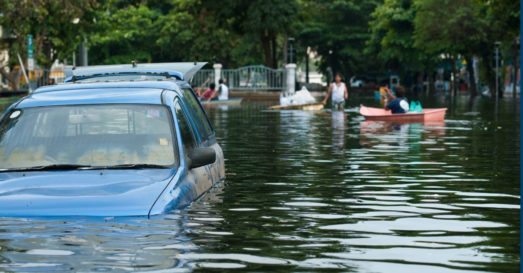
Flooding can severely restrict food supply in low-income countries. It destroys crops and food stores, kills livestock, obstructs supply routes and leads to higher food prices.
The UN World Food Programme (WFP), the world’s largest humanitarian organization, has contracted Floodbase to supply emergency flood analytics for countries affected by food insecurity.
WFP decision-makers need these reliable data to understand where catastrophic floods are likely to strike and where flooding is occurring in real time. This intelligence enables them to deliver food and cash to at-risk communities quickly in emergency situations. It also allows them to repair assets for long-term food security rapidly, such as water harvesting systems.
Many countries participating in the WFP are at heightened risk of food shortage because they lack local flood data. To provide reliable, consistent flood alerts regardless of data scarcity, Floodbase’s platform needs modeled risk data to supplement earth observation (satellite) data and hydrometeorological data.
Learn more about how Fathom’s data can be used to support international development projects >
Quote “As data scarcity is an issue in much of the world, we’ve built our platform to intake data from multiple sources. By incorporating Fathom data, we have strengthened our flood risk metrics for Zimbabwe.”
Discover Fathom’s Global Flood Map – the first global flood map to provide risk professionals with all perils and climate options.
The result
Since 2021, Floodbase has used Fathom data to help WFP Zimbabwe and Tajikistan better achieve their food security goals. A wide range of decision-makers, including country planners, disaster managers, first responders and government focal points, have received highly accurate, actionable flood data that strengthen decisions on how to protect vulnerable communities from flooding and climate shocks.
Floodbase’s work in Zimbabwe
Nearly two-thirds (63%) of people in Zimbabwe live below the poverty line and the country ranks 108th of 119 in IFPRI’s 2017 Global Hunger Index. The devastating effects of climate shocks are intensifying already-severe food shortages here.
Floodbase provides WFP Zimbabwe with emergency maps of forecasted flood events. These support an accurate understanding of the floods’ immediate impact on communities, agriculture, and important assets.
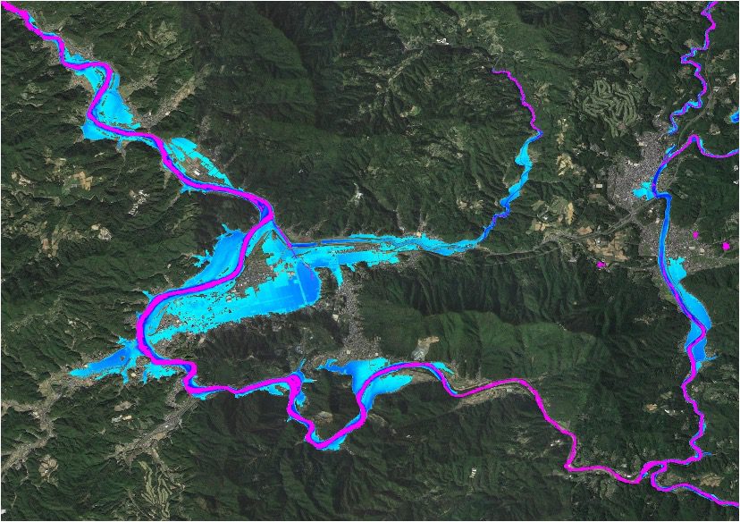
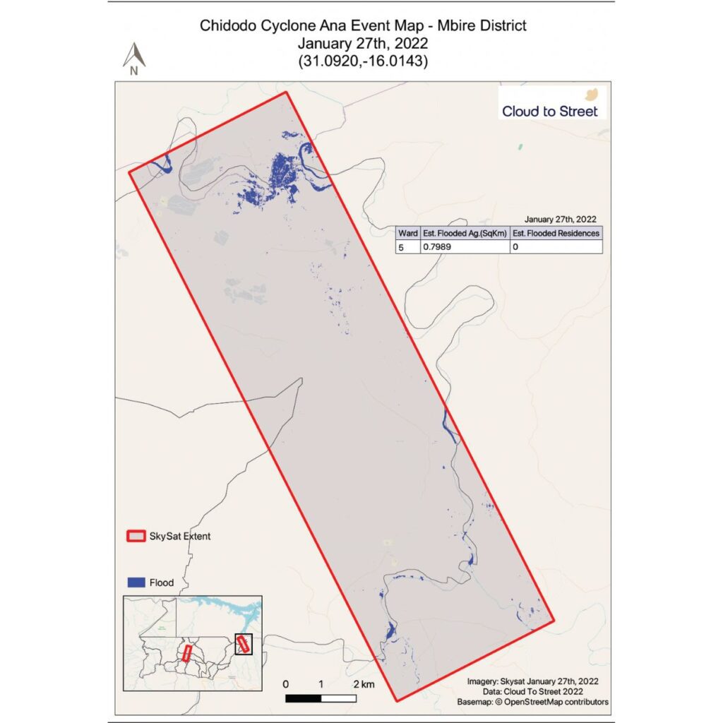
This intelligence proved critical during Tropical Storm Ana in 2022. During this emergency, the maps shaped WFP Zimbabwe’s first response to major flooding in two vulnerable regions, Chidodo and Mushumbi Pools. Further, they supported vital communications with government decision-makers who urgently needed accurate information on the floods’ impacts and locations.
Through Floodbase, Fathom’s Global Flood Map also helps WFP Zimbabwe understand the country’s risk to infrequent severe flood events. With Floodbase’s system, WFP Zimbabwe has made planning decisions that identify and protect communities at the most risk of high-impact floods.
Fathom & Floodbase present how they integrated Fathom’s flood hazard maps with Floodbase’s earth observation & satellite data covering challenges in international aid & disaster risk management.
Floodbase’s work in Tajikistan
Tajikistan has the highest malnutrition rates in Central Asia. Nearly one-third (30.1%) of its people are undernourished and it has a long history of severe floods that compound food insecurity. The World Bank reports Tajikistan as the country most vulnerable to climate change in Europe and Central Asia.
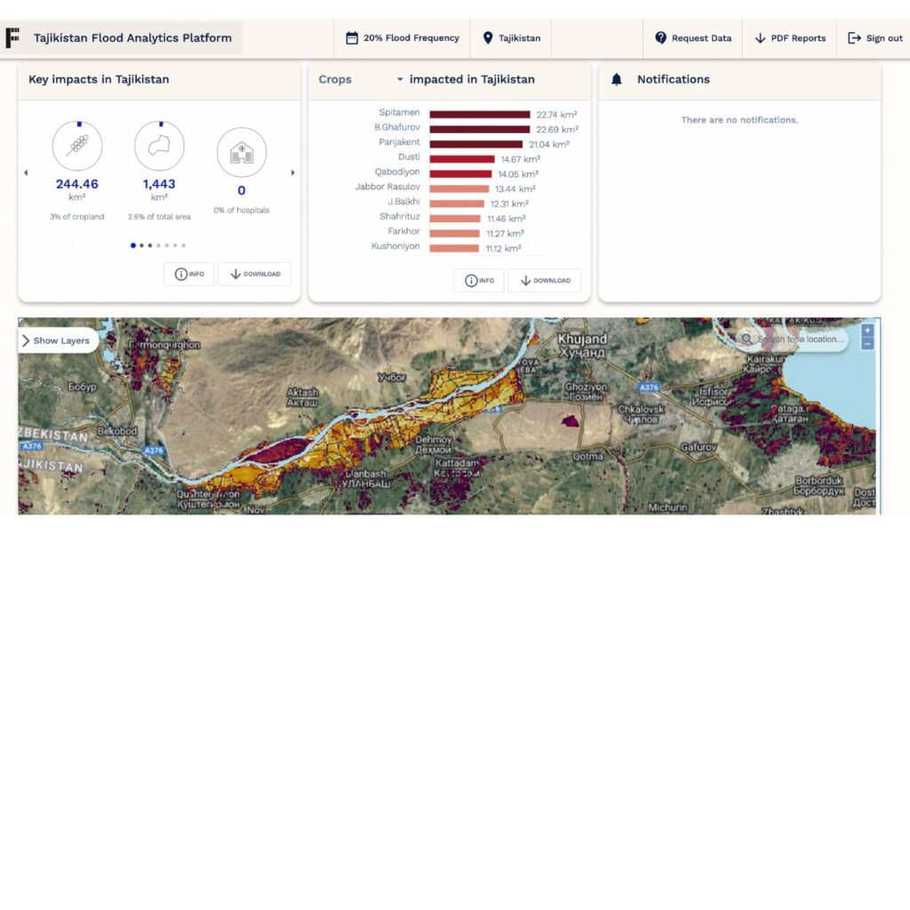
Floodbase has worked with WFP Tajikistan on projects that have benefited from Fathom’s Global Flood Map. These include a disaster management system for the Government of Tajikistan’s Committee of Emergency Situation and Civil Defense.
The government and the University of Central Asia have further used Floodbase for country-wide flood-risk planning and infrastructure vulnerability assessments. In addition, the updated flood risk maps have allowed institutional partners to understand downstream flood risks in Dushanbe and surrounding areas.
Quote “At Floodbase, we value scientific rigor and transparency. This is one of the main reasons we chose to work with the team at Fathom.”
Related case studies

AXA: a cutting-edge catastrophe model for Europe
Learn how Fathom and AXA built a state-of-the-art catastrophe model that strengthens AXA’s financial resilience and regulatory reporting.
Arup & World Bank
Fathom & Arup demonstrate how rapid, data-driven flood modeling can quantify the impact of urban greening on flood extent, soil erosion, and urban heat. Discover how NBS can create more resilient cities.
Texas Water Development Board
Texas Water Development Board uses Fathom data, and others, to accelerate the development of the first statewide flood planning program in the absence of publicly available flood data.
FEMA’s Risk Rating 2.0
Fathom provided FEMA with a more accurate, up-to-date picture of US flood risk which informed how the NFIP prices insurance, using Fathom-US flood map.