Prof. Paul Bates’ interview with Terrawatch Space Podcast
Fathom Chair, Professor Paul Bates, joins Aravind Ravichandran on the Terrawatch Space Podcast to explore the state of flood modeling today, its evolution over the last 30 years and where satellite data fits into the science and business of climate and flood intelligence.
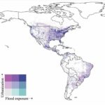
From a research group working at the University of Bristol to a team now numbering 50 people, Fathom has created a unique position building automated flood models that have extended traditional approaches to hazard modeling to a global scale.
A key component of this is a wide range of satellite data sources that underpin how the technology represents the physical dynamics and processes of the real world. As Paul explains in the interview:
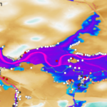
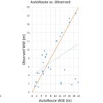
“The key satellite data is terrain information. In the past Shuttle Radar Topography Mission (SRTM) was our key data set. We spent many years with colleagues, particularly Dai Yamaziki at the University of Tokyo, working out ways to clean up SRTM so that it’s suitable for flood modeling. Satellite terrain data gets the top of buildings and trees but for flood modeling, we want the bare earth elevation. So we spent a lot of time developing algorithms to clean up SRTM and we produced a couple of really influential datasets, one called MERIT and one called MERIT-Hydro, which fueled our flood modeling for quite a long time.
“More recently, we’ve been taking the Copernicus DEM, it’s slightly better quality and higher resolution than SRTM. And again, we’ve been spending time cleaning that up so it’s suitable for our purposes. We call it FABDEM, which is a forest and building removed Copernicus DEM version and that’s what we’re using for our global flood modeling. It’s producing really, really quite impressive results.”
Alongside discussing FABDEM, Aravind and Paul also explore the founding of Fathom, it’s product portfolio, the state of flood modeling today and NASA’s Surface Water and Ocean Topography (SWOT) mission. They also touch on the role of satellite data, why the quality of data is better than quantity and findings from Fathom’s recently published research on future flood risk in the UK.
“I feel passionately about the advantages of peer-reviewed and transparent science. You know, I’m a scientist by training. I’m primarily an academic. And that’s absolutely fundamental to what we do. But there’s also strong commercial value in it and it’s critical to Fathom’s ethos. We’re going to publish all the methods openly and transparently in peer-reviewed journal papers and we’re going to validate our methods. Be absolutely frank about where they work, and where they don’t. We don’t want our models to be oversold, and we don’t want people for using them for the wrong purposes. So we think it’s fundamental to our business ethos. And it’s also good practice scientifically.”
Listen to the podcast in full below.
About Terrawatch
It is Terrawatch’s purpose to create a resource for people who want to understand what is going on in the space industry. By facilitating conversations with experts in this field, Terrawatch aims to demystify earth observation, and satellite data and explore all of the markets that this technology is relevant within. This is achieved by ensuring that episodes are relevant to the industry in a way that is accessible to outsiders and provides companies to showcase what they have to offer.
Alongside Fathom, other notable guests include Floodbase, ATLAS Space Operations, NASA and ESA. You can find all of these and more by visiting the Terrawatch website.
Related research papers
Hyper-resolution PCR-GLOBWB: opportunities and challenges from refining model spatial resolution to 1 km over the European continent

A climate conditioned catastrophe risk model for UK flooding
Bare-earth DEM generation from ArcticDEM and its use in flood simulation

Comparison of estimated flood exposure and consequences generated by different event-based inland flood inundation maps
Use of hydrological models in global stochastic flood modeling
Urbanizing the floodplain: global changes of imperviousness in flood-prone areas