Until fairly recently, highly detailed flood mapping has been limited to small-scale models
The acquisition and implementation of the necessary data for whole countries, or even cities, has proved incredibly challenging
Yet, progress in modelling flood risk at large scales has ushered in a new wave of academic research into the inequality of flood risk suffered by communities around the world. Research from academics such as Wing, Swain and Smiley has told us that the risk we face is far greater than previously estimated and that the most vulnerable face the highest exposure.

In a commentary released last week, Professor Paul Bates left readers feeling hopeful about the future of flood modelling and our ability to address critical societal questions about the nature and economic impact of floods.
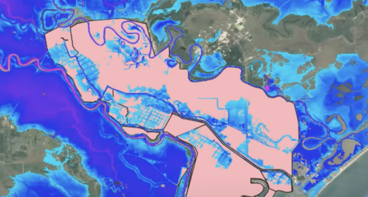
Paul examines recent research published in Nature Sustainability by Sanders et al., which outlines a new numerical model capable of simulating flooding at 3m spatial resolution across the greater Los Angeles area. Although a remarkable achievement, the technology is still in its infancy and hydrologists are now considering how this approach can be replicated at even larger scales.
Determining if this is achievable is not straightforward: the method benefits from a new flood inundation model, PRIMo7. Scaling this to the country or even continental level will need to be paired with new approaches that automate detailed modelling used at smaller scales.
As we are in now the midst of the 27th annual COP summit, considering advancing our understanding of flood risk is timely and of critical importance:
“Floods affect nearly a third of the world population, more than any other peril. Given the scale of devastation, flood risk deserves the same attention and risk assessment rigour as primary perils such as hurricanes.”
Martin Bertogg, Head Cat Perils, Cyber & Geo, Swiss Re Institute
Analysis from Swiss Re found that there were more than 50 severe flood events worldwide, resulting in combined economic losses of more than USD 80 billion in 2021.
Of these losses, only $20 billion were insured, highlighting that the insurance gap is growing and is now estimated at 75%.
In a peer-reviewed paper published just last month, Andreadis and Wing found that while many factors contribute to increasing flood risk, the continued development of floodplains is one of the most certain and significant drivers of flood losses.
Urban areas in 2015 occupied twice as much floodplain land globally than they did in 1985. Urban floodplain encroachment is not only increasing — but accelerating — and is happening faster in areas subject to more frequent floods.
For the United States, Wing’s paper on ‘Inequitable patterns of US flood Risk in the Anthropocene’ found that Climate change will drive up the financial toll of flooding by more than 25% by 2050 – with disadvantaged communities bearing the biggest brunt of the exposure.
In addition, government-provided flood maps can vastly underestimate flood exposure. Research from Saunders finds that far more Americans fall within the 100-year flood zone than suggested by FEMA. This is due to: (a) the accounting of pluvial flood hazards (not mapped by FEMA) and (b) the assessment that major flood channels cannot contain 100-year flood peaks.
Despite this, all is not lost. Where our systemic understanding of flood risk is limited, evidence indicates that people are making much more rational decisions around their flood risk now than in the past. This is highlighted in a wide-ranging analysis of the United States produced in collaboration with Jacob Bradt (Harvard) and Carolyn Kousky (Wharton), which found that voluntary insurance purchases are preferentially taking place in areas where Fathom’s model deviates from FEMA flood maps. This implies that even where FEMA falls short, people have a pretty good understanding of their local flood risk.
What this research confirms is that national-scale predictions of flood risk drastically underestimate our exposure globally. Yet, as we approach COP27’s ‘Water Day’ (14th November) we want to highlight the rapid progress that is being made towards our ability to confidently simulate hazard and the risk associated with it. As Bates, notes in his commentary:
“Harnessing the power of big data and machine learning may be one helpful strategy for making this happen; better use of remotely sensed data may be another.”
This COP27, Fathom is being showcased on the UK’s Department of International Trade Pavillion with a focus on adapting to extreme weather. Learn more: