-
Watson, A.,
-

-


The effects of anthropogenic global warming on the risk of flooding, droughts, and increasing sea levels have become increasingly apparent.
By 2050, it is estimated that winter rainfall will increase by 6%, summer rainfall will decrease by 15%, and river water levels may rise by up to 27% according to the Environment Agency.
Fathom’s collaborative research has explored the impact that climate change may have had on the unprecedented rainfall and resultant flooding seen during Hurricane Harvey in 2017.
Looking at the UK, Fathom-UK has forecast that 1.35 million properties will be vulnerable to flood risk by 2050, an increase of 24% from 2020.
In this article we discuss flood risk at four locations in the UK, outline some of the past flood events that have occurred in these locations, and summarise recent defence schemes that have been (or are being) implemented to reduce the risk of flooding in response.
We then outline our approach to modelling future flood risk in the UK and present examples showing the potential impact of climate change on flood risk at these four locations for 2020, 2030, 2050, and 2070.
Carlisle fluvial flooding
In 1968, following significant flooding caused by an estimated 1 in 75-year river flow, Carlisle’s first flood defences were constructed.
In January 2005, sustained heavy rainfall over parts of the Lake District and Pennines that form the headwaters of the River Eden resulted in a devastating downstream flood event in the city that affected 1600 properties.
In response the EA (Environmental Agency) invested £12 million in a local flood defence project which rebuilt the embankments of the River Eden and River Petteril to protect the city against a 1 in 200-year probability event. The embankments were made higher and wider with new flood walls and drain-down sluices to effectively drain water trapped behind defences.
A second stage of the project was also carried out which focussed on protecting the main city centre area which included a pumping station from Little Caldew to the River Caldew, along with new floodwalls and embankments.
Despite this work, the extreme rainfall of Storm Desmond in 2015 led to a new flow record on the River Eden at Carlisle. The new defences were overwhelmed as a result, leading to the flooding of more than 2000 properties.

Oxford fluvial flooding
Similar to Carlisle, Oxford is also an at-risk area for flooding. Having experienced two significant flooding events in 2014 and 2020, the government has developed an Oxford Flood Alleviation Scheme to create new streams with wildlife corridors for water overflow which will take floodwater away from built-up areas in the south and west prone to flood risk.


Avonmouth coastal flooding
Avonmouth is particularly vulnerable to tidal flooding from the Severn Estuary and fluvial flooding from the Avonmouth Rhine network.
The first stage of an £80m flood defence project, known as the ASEA Ecology Mitigation and Flood Defence Project has just been completed. This project is the largest project of its kind to be carried out in the West of England.
The main aims are to reduce flood risk to 2,500 properties and create 17km of flood defences to combat rising sea levels which are a result of climate change. This project builds new flood defences to protect against rising sea levels to reduce the level of flood risk in Avonmouth for the next 60 years.


Hull coastal flooding
In recent years, Hull has been greatly affected by flooding as it is one of the lowest-lying cities in the UK, as well as being a coastal area next to the Humber estuary.
The worst flooding event in the past twenty years was the June 2007 floods which resulted in a significant loss of life and livelihoods in the city. This year a flood alleviation programme was completed by the EA which is believed to protect at least 113,000 homes from being flooded.
Modelling flood defences
When it comes to modelling the impact of defences within a national-scale modelling framework (such as Fathom-UK), where available we incorporate the location and standard of protection contained within national flood defence datasets such as those published by the Environment Agency and Natural Resources Wales. In areas of missing or incomplete data we estimate the standard of protection based on both urbanisation and global flood defence standard and datasets.
Furthermore, we also deploy an algorithm developed by Fathom’s Chief Research Officer Dr. Oliver Wing (published here) that detects topographic features that would control the flow pathways of floodwaters, such as levees, from LiDAR data, allowing us to incorporate additional features not contained within national defence datasets.
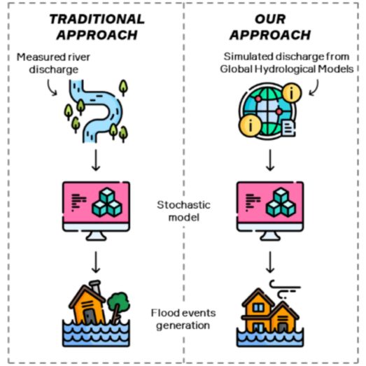
Modelling the impacts of climate change on fluvial flood risk
To understand how fluvial flood risk may change in the future, we first estimate how rainfall and river flows may change in the future. To do this, we extract future extreme precipitation from the ensemble of climate models underpinning the latest Met Office future climate projections (UKCP18) and calculate changes in extreme precipitation across the UK between present day and 2030, 2050 and 2070 under the RCP8.5 emissions scenario. Changes in river flows were then calculated by taking temperature and precipitation projections and running these through an ensemble of rainfall-runoff models.
The calculated changes in precipitation and river flows were then used to perturb the present day data so that we could directly simulate the impact of changing precipitation and river flows through our hydrodynamic model and understand how inland flood risk may change in the future.
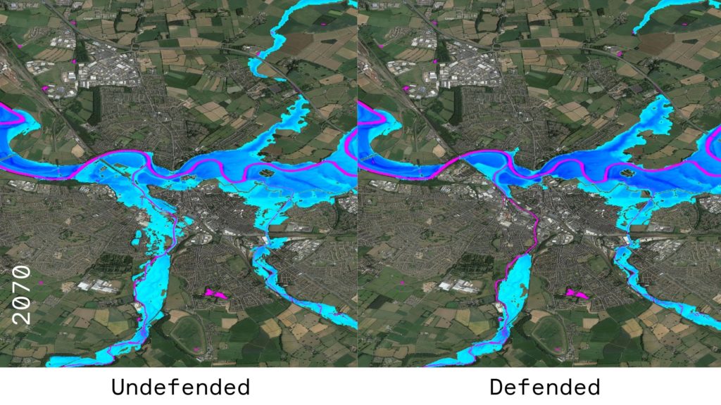
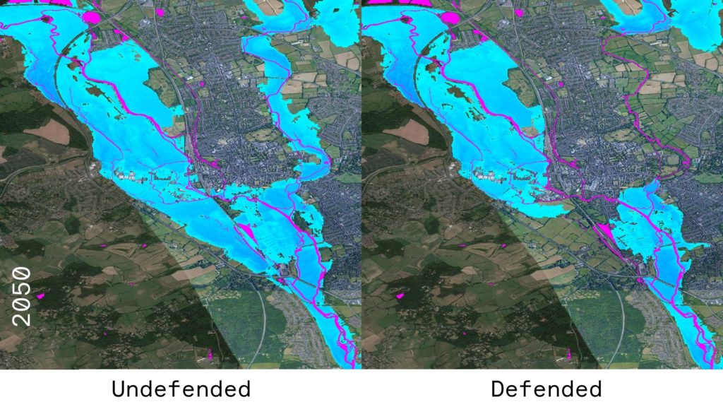
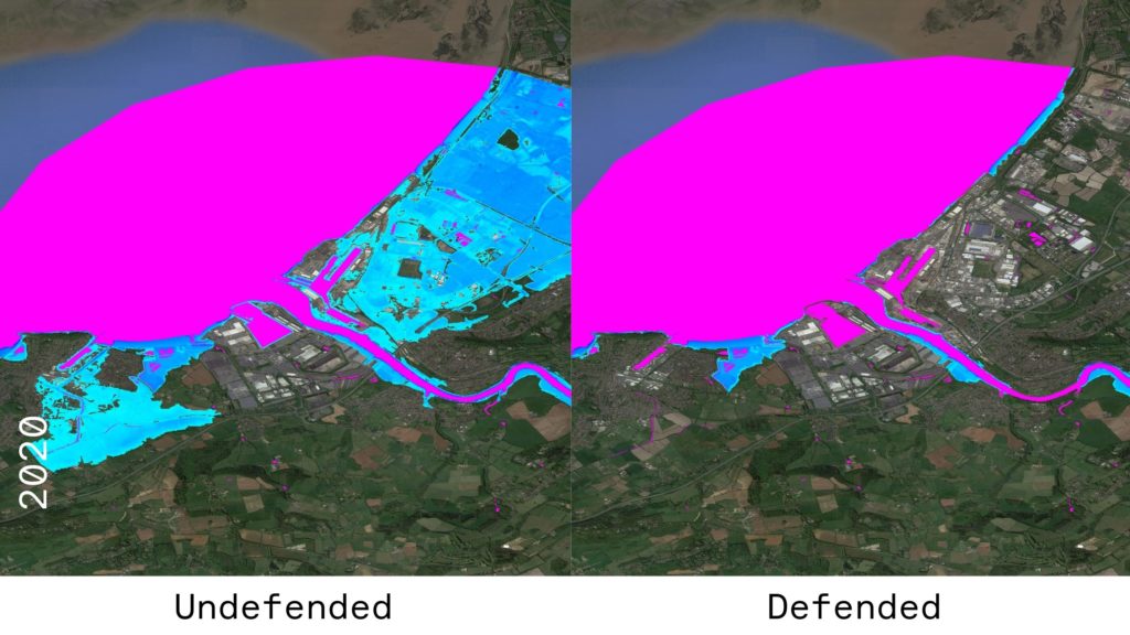
The examples below show, given the climate change methodology above (further examples of which can be found in some of our other publications), how fluvial flood risk may change in the future in Carlisle and Oxford, both with and without the defence assumptions outlined previously.
It is important to note that these estimates are based on the present day defence assumptions and highlight how flood risk may change based solely on changing river flows. They do not consider how defences may also change in the future.