Fathom Developer, Gaia Olcese, shares her research poster titled: “Can hydrological models be used to characterise spatial dependency in global stochastic flood modelling?”
This research poster was first presented at the AGU (American Geophysical Union) Fall Meeting 2021 in New Orleans and forms part of Gaia’s PhD research project with the University of Bristol.
What is AGU?
The American Geophysical Union (AGU) is a non-profit organisation, established by the National Research Council in 1919.
AGU’s main mission is to support the global advancement of discovery in Earth and space sciences, with over 60,000 members in 137 countries.
Every year they host a range of conferences to bring together international scientists to share their research findings with their diverse audience of academics, and public and private sector stakeholders.
AGU Fall Meeting 2021
This year’s Fall Meeting is held in New Orleans, LA, and online in a virtual format. Over 26,000 attendees are expected to attend the hybrid conference, including scientists from all over the globe.
Keynote speakers at the event include John Kerry, a climate expert who was the first Special Presidential Envoy for Climate and first National Security Council climate change Principal, Robert Bullard who is well-known as the “father of environmental justice”, and more.
As part of their annual meeting, they invite researchers to share their findings with the attendees.
Gaia will be presenting her research project along with other PhD students from the School of Geographical Sciences, as well as other scientists in the field. This will take the form of a hybrid poster presentation, where she will present online and in-person at the event.
The Research Project
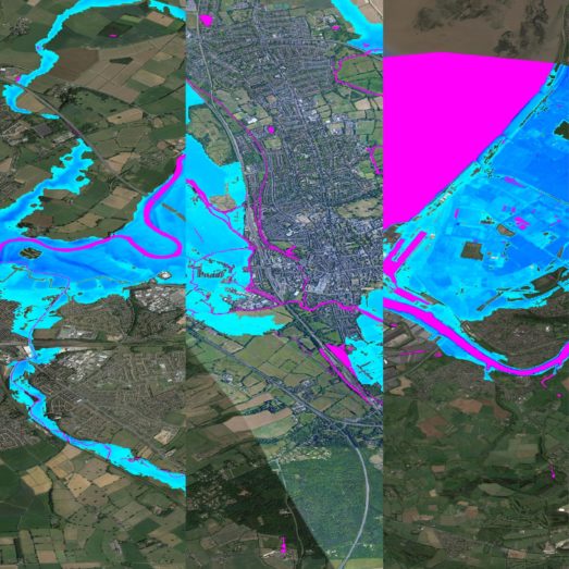
This research investigates the possible future development of global stochastic flood modelling; specifically focusing on how synthetic river discharge from global hydrological models can be used in large-scale stochastic flood modelling, instead of measured river gauge data.
Traditional flood models simulate flood hazard maps with a constant return period in space, limiting their usefulness as they do not take the spatial structure of flood events into consideration.
Stochastic flood models typically use historical flow data to understand the spatial dependency between sites. However, access to detailed discharge data is needed, which creates challenges for data-scarce areas.
This is why global hydrological models (models that provide simulated river discharge globally) could be a solution. Simulated discharge could potentially be used instead of measured flow to estimate spatial dependency in data-scarce areas, since model data is not subject to station density issues associated with river gauges.

Testing the Method
The global stochastic model was run using simulated discharge from the University of Tokyo’s CaMa-Flood and the University of Ultrecht’s PCR-GLOBWB hydrological models.
This analysis was then compared against global discharge datasets taken from the Global Runoff Data Centre (GRDC) data and Beck et al.’s daily streamflow global dataset.
By comparing results from both data, Gaia was able to evaluate whether the model-based approach could replicate the spatial dependency found in gauged data. Based on the availability of gauge data, Gaia’s research used case studies in Australia, Malaysia, Thailand, South America, South Africa and Europe.
Research Results
Findings from this research suggest that observed errors were comparable to Wing et al.’s research results in the US. Which found that….
When used to estimate flood losses, the model-based approach produces similar numbers to the gauge-based method, suggesting that stochastic models driven with synthetic discharge could be used to understand flood losses where river gauges are not available.
In the future, this enables us to generate more realistic flood event datasets in parts of the world that have scarce existing data.
Read more about Gaia’s research project, by viewing her digital research poster. Here you can find videos, images, and in-depth insights into the data analysed and collected.