
A panel of flood risk professionals discuss what the future of flood mapping looks like and how hybrid modeling and public-private collaboration works.
Key takeaways
As the US flood mapping landscape shifts, professionals are seeking new approaches to flood mapping

With flood risk increasing, the role of federal agencies is being scaled back. This is driving a growing demand for private data

Proprietary and non-proprietary, or public, data were designed for different uses – it’s crucial that your model fits your use case

Examples of successful blended data approaches and private-public partnerships can be found in Illinois, Texas and Canada

Introduction
The US flood mapping landscape is shifting dramatically. Regulations and policies around managing flood risk are evolving, funding is being scaled back and federal agencies are passing responsibility for flood risk management down to the state level.
Professionals at the front line of flood risk are seeking new approaches, data sources and partnerships that will help them navigate this shifting landscape and tap into the opportunities these changes could present.
Fathom recently partnered with the Association of State Floodplain Managers (ASFPM) to bring together a panel of industry leaders for a webinar discussion in which they shared their insights on the emerging approaches to flood mapping. The speakers were:
- Barney Austin, Vice President, Hazen and Sawyer
- Professor Paul Bates, Chairman, Fathom
- Meg Galloway, Senior Policy Advisor at the Association of State Floodplain Managers
- Glenn Heistand, Head of the Coordinated Hazard Assessment Mapping Program (CHAMP) at the Illinois State Water Survey
- Jacqueline Higgins, Head USA Public Sector Solutions, Swiss Re
- Gavin Lewis, Head of Engineering, Fathom
Here are the key takeaways from the webinar, which you can also watch on demand.
What does the new era of US flood mapping look like?
Flood mapping is an area that has changed rapidly over the last decade, driven by increasing data availability, new numerical methods and new data sets.
“We’ve moved, quite quickly, away from traditional floodplain mapping, where we had to go site-by-site building models with locally sourced data, to more national or state-scale approaches, where we can build models of large regions near automatically.” Professor Paul Bates, Chairman of Fathom
These advances have happened just as the roles of FEMA and other federal providers of flood information are shifting and being scaled back.
Meanwhile, climate change and urbanization are contributing to a rise in flood risk. Meg Galloway, Senior Policy Advisor at the Association of State Floodplain Managers, points out that flood losses in the US have doubled every decade since 1990 – from about $5.5 billion to $46 billion per year today. Yet only one-third of the US stream, river and coastline flood hazards have been mapped through FEMA’s flood mapping program.
These gaps in FEMA coverage are the main driver of the demand in private flood data at the state level. Professionals are increasingly looking to third-party providers as an alternative source of flood risk tools, maps and models to complement what is publicly available.
75% of flood risk professionals see gaps in FEMA coverage as the main driver of the demand for private flood data at the state level.
Explore the shifting landscape of US flood data
Different models for different use cases
A key takeaway from the webinar is that there is no single ‘best’ approach to developing flood risk information. There are different techniques and a variety of data, both proprietary and non-proprietary, all designed for different applications.
“All flood mapping information is valuable for raising risk awareness and planning for more resilient communities. However, different mapping processes work best for certain applications. Modeling and mapping needs to fit the use.” Meg Galloway, Senior Policy Advisor at the Association of State Floodplain Managers
Uses of public vs proprietary flood information
Generally speaking, non-proprietary (public) maps such as FEMA’s were designed for regulatory use. They are reproducible and transparent, are PE (Professional Engineer) certified and legally defensible throughout a due diligence review and comment period. This makes them suitable for defining flood risk zones for hazard awareness, mandatory flood insurance purposes and local regulation.
However, they were not designed for predicting all areas that will flood or all that will not. They only cover a subset of recurrence intervals, do not cover future climate scenarios and only show larger river channels.
This is where proprietary flood information tools come in. They can provide flood risk data and mapping for large areas and can be quickly updated to incorporate new or more refined techniques.
Fathom’s Head of Engineering, Gavin Lewis, reiterates the importance of using the right maps for the application:
“What’s most important is having the appropriate data that’s fit for purpose, and not trying to apply maps that were developed for regulatory purposes to a range of other needs.” Gavin Lewis, Head of Engineering at Fathom
84.62% of poll respondents said filling gaps in FEMA coverage was an opportunity for private flood data to support flood risk professionals in understanding broadscale risk.
In action: National and regional applications
The panelists talked us through some real-life examples of how different types of data and approaches helping to tackle the challenge of flooding in the public sector.
Blending data for mitigation planning in Illinois
First, Glenn Heistand, head of the Coordinated Hazard Assessment Mapping Program (CHAMP) at the Illinois State Water Survey, described how his team blended regulatory data for the state of Illinois Hazard Mitigation Plan update.
Glenn noted that multiple federal agencies besides FEMA provide flood information, and the pool is being expanded with a recent proliferation of third-party providers. It’s important to choose the most suitable dataset, and data provider, the job.
“It is a multiple-step question process. What are the management goals that you’re trying to achieve? What kind of uncertainty considerations do you need to accommodate? And then you need to decide whether to ingest the information or to replicate it.” Glenn Heistand, Head of the Coordinated Hazard Assessment Mapping Program (CHAMP) at the Illinois State Water Survey
In the case of Illinois, the team needed data that was consistent across the whole state, that had future conditions built in and was consumable for the risk analysis they needed to perform. To meet these goals, third-party data was needed instead of FEMA data and, because it wasn’t being used for a regulatory or design purposes, it suited the team’s purpose perfectly.
“Having that transparency and understanding about what the information is good for, where its limits are and where it’s best applied is important.” Glenn Heistand, Head of the Coordinated Hazard Assessment Mapping Program (CHAMP) at the Illinois State Water Survey
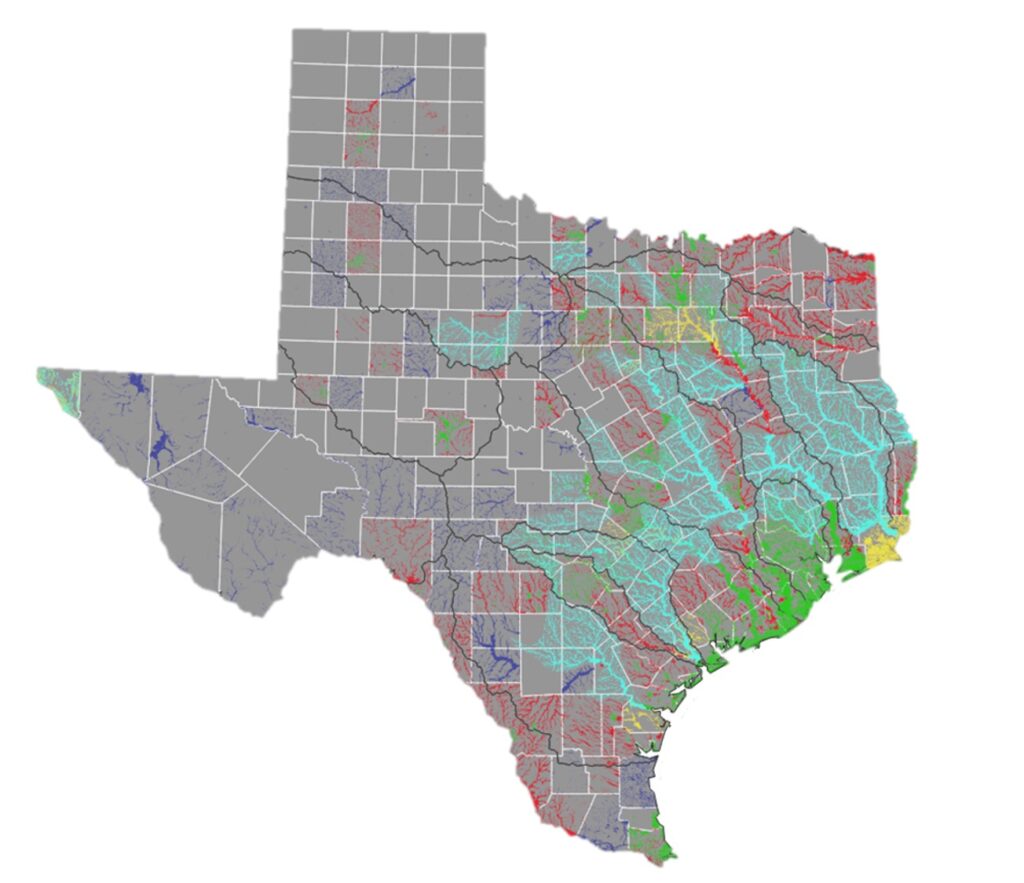
Using Fathom’s statewide model in Texas
Barney Austin, Vice President at Hazen and Sawyer, talks about using Fathom’s data for the state of Texas’ innovative, stakeholder-driven flood plan, which was used to develop state-wide flood mitigation strategies.
The challenge Barney’s team had was a lack of flood information (around 40% of the state had no floodplain maps at all) and a looming deadline to produce a flood plan.
By using Fathom’s model, which was updated with the latest state-wide LiDAR data, the team were able to produce 100-year and 500-year floodplain maps for the entire state in just a few months.
“The Fathom model allowed regional flood planning groups to fill in the gaps and identify and prioritize mitigation strategies… It was done super-quickly and with an updated DEM.” Barney Austin, Vice President at Hazen and Sawyer
Statewide flood mapping with Texas Water Development Board
Discover more about the first statewide flood planning program in Texas and Fathom’s work.
Fathom, Aon Impact Forecasting and the Canadian government partnership
Fathom’s Head of Engineering, Gavin Lewis, talked about Fathom’s work in partnership with Aon Impact Forecasting and the Canadian government to deliver the first national flood maps for Canada.
The challenge for the government was that all of Canada’s different territories, municipalities and provinces had built their own datasets, meaning there was no consistent view of flood risk.
Fathom worked with Aon Impact Forecasting to develop a single, standardized flood-risk dataset for the government. This is now being used across departments to support multiple key objectives, including:
- Raising the awareness of flood risk for the citizens of Canada
- Screening and validating government project investments to ensure they are resilient and future-proofed
- Supporting the development of Canada’s national flood insurance program, providing the core data that underpins its design and operation
“We’ve been working closely with the Canadian government to structure the data and the licensing to ensure that what we’re producing can actually be used across government, and that specific data sets can be put in the public domain.” Gavin Lewis, Head of Engineering at Fathom
Discover more about the Government of Canada’s flood hazard initiative
The importance of public-private collaboration
Jacqueline Higgins is Head of Public Sector Solutions North America at Swiss Re, Fathom’s parent company. She grounded the discussion within the broader policy environment by highlighting the ongoing FEMA Review Council process, which started in early 2024. This review is reassessing how FEMA manages disasters and looking at reforms to the National Flood Insurance Program (NFIP), with an emphasis on the role the private sector could play.
With flood insurance take-up rates stagnating, protecting communities requires better, modernized flood mapping, and coordinated action among federal, state and private actors.
“As long as risk is solely determined by FEMA maps, and purchase is driven by mortgage requirements, the flood protection gap is unlikely to materially improve.” Jacqueline Higgins, Head of Public Sector Solutions North America, Swiss RE
Interest in hybrid models is rising
Swiss Re’s Jacqueline Higgins has noticed a rising interest in hybrid models and data among her clients, who need an “understanding of that comprehensive risk analysis… from the regional scale down to the local scale, rural and urban.”
Clients are interested in using hybrid models to support:
- Infrastructure vulnerability assessments to pinpoint weaknesses in roads, utilities and critical services.
- Better forecasting and planning so event responders can have stronger early warning and scenario tools.
- Accurate pricing and informed coverage options, including parametric insurance
“When it comes down to the risk transfer component, they really want this hybrid data to make smarter insurance decisions.” Jacqueline Higgins, Head of Public Sector Solutions North America, Swiss RE
Conclusion: Hybrid models and collaboration are the future of flood mapping
The consensus among all the panelists was that modernized maps along with a more collaborative approach to flood management, are urgently needed to build community resilience.
And when it comes to choosing public vs private sources of data, it is not a case of ‘either/or’. Rather, it is a case of using the right data for the job – and that will likely be a blend of both types of data:
“It’s about using the right data for the right purpose, and ensuring you’re using the most appropriate data for the questions you’re looking to answer” Gavin Lewis, Head of Engineering at Fathom

Watch the webinar on-demand in full to explore the challenges and opportunities of the evolving flood data landscape and how public and private data sources can work together to support smarter, more resilient decision-making at the state, local and project level.