
Our understanding of our world relies on data
Painting a detailed, accurate and up-to-date picture of our planet’s global terrain is essential to a wide and vital range of workflows, from performing site assessments for the construction and energy industries to modeling dangerous landslides and flood events. As our climate changes, understanding our planet’s surface and perils is more important than ever.
While once largely old, coarse and patchy, terrain data and research is becoming increasingly comprehensive and detailed as both our observational capabilities and data processing techniques improve. This terrain data is available in the form of digital elevation models (DEMs), which map our planet’s surface elevation via satellite.
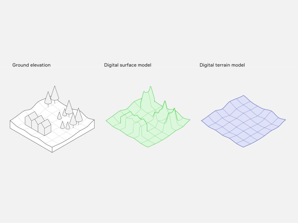
Specific data are needed for different applications: when considering land uses around an urban area, for instance, a model that shows the elevation of the area and all of its infrastructure and vegetation (a DEM known as a digital surface model or DSM) is best to appreciate the lay of the land. However, when modeling natural hazards or working with linear assets and digital environments, the best map is one without surface features (a digital terrain model or DTM), as such features can obscure a landscape and disrupt our ability to create clear and accurate maps.
Comparing FABDEM to other DEMs
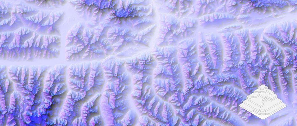
Surface vs terrain: Mapping our world
Earth’s surface is covered by terrain data at several spatial scales – from ‘fine’ (a resolution of <10 meters) to national and regional. Fine spatial resolution DEMs are typically derived from laser altimeter (LiDAR) data and considered the terrain ‘gold standard’; however, they offer limited coverage at wider geographical scales. DEMs at the intermediary scales – high, coarse, medium – often contain lots of noise and error, are based on older data, and map the surface without removing obstructing objects, limiting their versatility. While useful for local purposes, national and regional DEMs vary in quality and calibration, and do not offer a global view.
Global DEMs have been available for some time, with many based on data gathered by NASA’s Shuttle Radar Topography Mission (SRTM) in 2000. This includes NASADEM, a more recent reprocessing of SRTM data that offers a 30-meter resolution map of Earth’s surface and infrastructure (NASADEM is not near-global, however, omitting wide swathes of boreal forest).
Other available DEMs exist in the form of the European Space Agency’s COP-DEM (the Copernicus GLO-30 Global and European DEM), and MERIT DEM (the Multi-Error-Removed Improved-Terrain DEM). COP-DEM GLO-30 is regularly updated using European satellite data. It represents the surface of our planet including buildings, infrastructure and vegetation also at a resolution of 30 meters, and is ranked as the best surface model available. Working alongside academic partners, we published the methodology for MERIT DEM in 2017, having developed the dataset to eliminate errors and filter data in DEMs from SRTM and the Japanese space agency’s (JAXA’s) Advanced Land Observing Satellite, AW3D Standard. It offers a 90-meter resolution.
While MERIT DEM removed some surface features (forests, but not buildings), a true ‘bare earth’ model (or DTM) was lacking until Fathom’s FABDEM (Forest And Buildings removed Copernicus DEM) in 2022 – the first true global DEM with forests and buildings removed at a 30-meter resolution. FABDEM is based on COP-DEM GLO-30 with a correction algorithm applied to remove artifacts, and is ranked as the top DTM on the market. FABDEM has been extensively and independently validated and found to be more accurate than COP-DEM GLO-30 in both forested and built-up areas, roughly halving the mean vertical error in the former regions and reducing it by around one-third in the latter.
Fathom has now released their next generation of global terrain data in FABDEM+, a true global bare-earth model combining FABDEM with high-quality laser altimeter (LiDAR) data gathered as recently as 2023. FABDEM+ has far wider coverage than either FABDEM or LiDAR alone and higher vertical accuracies than DEMs based on satellite data, setting a new standard for globally consistent and accurate multi-source models. FABDEM+ offers the best of FABDEM and local data: a seamlessly blended DTM that combines thousands of data sources into one.
2026 update: Introducing FathomDEM+
Fathom have released their newest world-leading DEM, FathomDEM+. Unlock global accuracy with advanced machine learning techniques to close the LiDAR gap.
From FABDEM to FABDEM+: Every meter matters
When first released, modeling flood risk was the application of direct relevance to Fathom. We produce research and products that provide scientifically rigorous water and climate information on a worldwide scale. FABDEM emerged as our Global Flood Map was developed, an award-winning map which provides the most robust and comprehensive set of hazard data and flood risk information in the world (and has been regionally enhanced to provide even more value in the US).
Discover where Fathom’s Global Terrain Data sits within Fathom’s Product Stack
However, terrain data are invaluable far beyond flood mapping and risk mitigation, with businesses, governments and communities across the world standing to benefit hugely from a more rigorous understanding of Earth’s surface.
The best source of topographical data is LiDAR, which is typically gathered by air rather than space-based satellite. LiDAR can achieve high accuracy with errors of well below 30 centimeters; it can also penetrate tree canopies to reveal the ground beneath, and distinguish between objects on the surface. However, LiDAR is usually only gathered locally, and disproportionately covers high-income countries and urban areas. It is collected and stored in a siloed fashion, with regions calibrating vertical baselines differently. This makes it challenging to wrap LiDAR data into one cohesive package – as offered by FABDEM+, the first DEM to assimilate all open LiDAR globally.
To create FABDEM+, we blended all available local LiDAR data into the FABDEM dataset to increase coverage and resolution: thousands of disparate sources, all processed to remove errors and ensure consistent transformation, data and geoid, and with associated metadata for full transparency. FABDEM+ provides a resolution of 30 meters worldwide and 10 meters in areas where enhanced LiDAR data is available (30+ countries including the US), making it hugely versatile and valuable to myriad users.
Register for our global launch webinar for FABDEM+
Applications of Global Terrain Data – FABDEM+
Putting FABDEM+ to use: Delivering certainty
A core application of FABDEM+ is mapping natural hazard and risk management. Vertical errors can lead to misleading hazard maps and exposure assessments, with potentially deadly and costly consequences. As a true bare-earth DEM incorporating high-quality LiDAR, FABDEM+ reduces the chance of error when making high-risk decisions. The LiDAR in FABDEM+ offers increased vertical accuracy of up to 15 centimeters and a resolution as high as 25 centimeters in places – a substantial improvement compared even to the class-leading 30 meters achieved elsewhere. This provides the most accurate possible depiction of Earth’s terrain – essential for assessment of other perils including landslides and wildfires, and for the subsequent planning of emergency response, rescue and aid missions by NGOs and public services.
Alongside its uses in risk mitigation and compliance, DEMs stand to play a key role in infrastructure planning and remote site surveying. FABDEM+ offers easy access to large volumes of clean, consistent, up-to-date data – the best available for a given location – so that time and money can be saved by planning and scheduling projects more efficiently (whether this be wastewater networks, trainlines, or planning for renewables or geotechnics). This has additional value when combined with risk modeling; using FABDEM+, development can be concentrated in regions of lower risk, and especially peril-prone regions can be purposefully avoided.
Importantly, FABDEM+ can validate the flood maps and models that insurers and other professionals currently use, to benchmark outputs and to fully elucidate how real-world flooding could affect their portfolios. The new DEM uses FABDEM as its base, which has been definitively and independently validated – including in the highlands of Vietnam and a forested mountain catchment in Canada – and deemed a ‘best in class’ data product.
Fully understanding our world
Bare-earth mapping is essential for us to fully understand our world. We cannot accurately use models that stop at the tree canopy, leaving the surface below unexplored – and any model we use is only as good as the data and techniques used to build it.
Until recently, the availability of suitable terrain data was a severely limiting factor in the accuracy, usefulness and therefore value of the global models that could be built, with data-poor areas represented by legacy data gathered over two decades ago by SRTM. Advances such as COP-DEM GLO30, MERIT DEM and more began to change this, but still contained obscuring vegetation, buildings and infrastructure, limiting the true functionality of the data. FABDEM offered the first true global DEM with forests and buildings removed at a 30-meter resolution – and now FABDEM+ takes this one step further, incorporating LiDAR with a resolution of up to 100 times higher.
FABDEM+ is a clean and consistent bare-earth dataset – in short, it sets a new standard for globally consistent multi-source digital elevation models.