
The impacts of flooding on hospitals can be devastating and long-lasting.
The impacts of flooding on hospitals can be devastating and long-lasting. The official guidance in the US is to avoid building critical health facilities within flood hazard areas, but a recent study has found that hundreds of hospitals are at risk of flooding. Fathom’s Gavin Lewis sat down with Elise Ibendahl and Gabrielle Sobel from Jacobs to talk about the flood risk to critical health facilities – and the practical steps we can take to make them safer.
Jump to:
Built to protect but not protected: The impact of flood on hospitals
In harm’s way: The US hospitals at risk of flooding
Policy changes affecting hospital flood preparedness
The flood data gap: Protecting hospitals before the waters rise
The reality of risk for healthcare professionals
A system-wide approach to building resilience
Taking action: A healthcare flood resilience study in practice
When a hospital is hit by flooding, the direct impacts have the potential to be extremely severe. Among them is the threat of evacuations, blocked access to emergency care, power outages and damage to critical infrastructure such as electricity and water systems that could disrupt operations.
Then there is a long list of indirect impacts – recovery costs, loss of income, a surge in demand along with reduced capacity and staff shortages, loss of access to patient care, and so on.
In the US, FEMA and local jurisdiction guidance encourages facility owners, planners, and designers to avoid building critical facilities, which include hospitals, within flood hazard areas. However, as recent events have shown, this is an ideal that, for various reasons, can fail to protect facilities from flooding in practice.
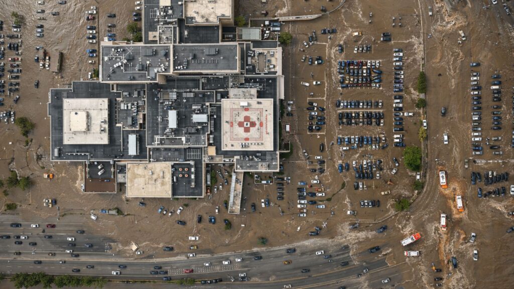
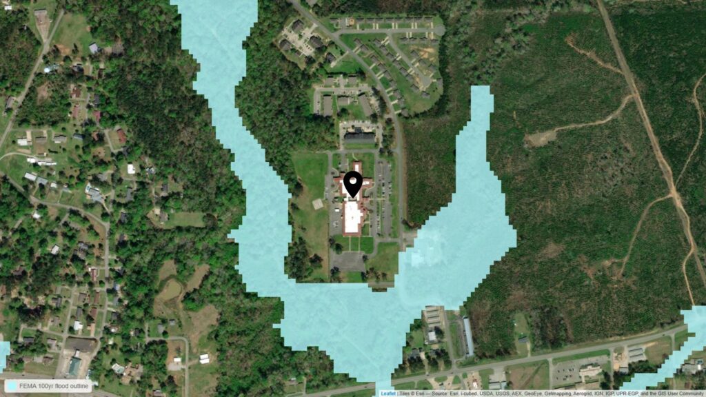
In 2024, a Tennessee hospital was severely impacted by a flash flood. Ceilings collapsed and walls caved. The staff and patients were evacuated but the hospital building, which was constructed in 2018, was destroyed. Why was it so devastated? The facility was built on a 500-year floodplain beside a large river. And this scenario is far from unique.

KFF Health News was among the first to look at nationwide hospital flood risk in an era of warming climate and worsening storms. Fathom’s 100-year flood risk data was overlaid to mapping of 7,000+ inpatient facilities across the US to identify regions of overlap.
The analysis found:
At least 170 US hospitals face major flood risk, totaling nearly 30,000 patient beds from coast to coast.
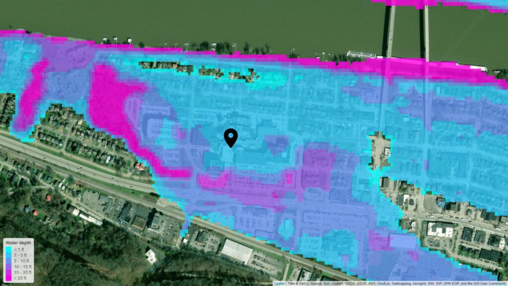
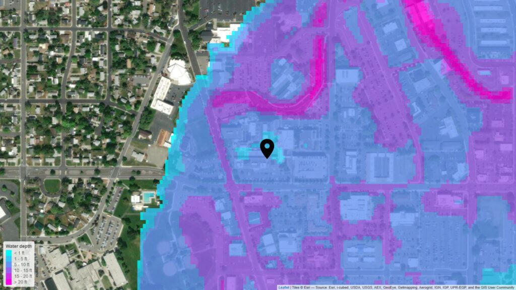
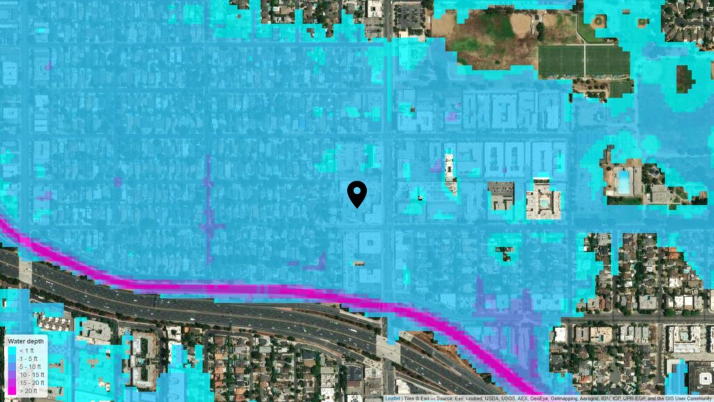
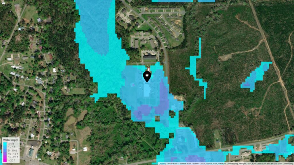
Some of these at-risk hospitals could potentially be under 15 feet of water in a 1-in-100-year flood event.
About one-third of the 170 hospitals identified as at risk fall outside FEMA’s 100- or 500-year flood hazard zones. This aligns with Fathom’s Flood Risk Index, which shows that, in most states, more than half of the average annual flood losses occur outside FEMA’s defined Special Flood Hazard Area (SFHA).
Flood risk is more than just a coastal issue. While flooding threatens dozens of hospitals in coastal areas, 39 of the 170 hospitals at risk of flooding are inland and are threatened by fluvial flooding.
At least 21 of the at-risk hospitals are “critical access hospitals”, meaning they are, on average, 25 miles from the next nearest hospital.
These findings are likely an undercount of hospitals at risk because the investigation overlooked pockets of potential flooding at some hospitals. It also excluded facilities like stand-alone emergency rooms, outpatient clinics and nursing homes.
Fathom’s Flood Risk Index offers a snapshot of flood risk in every US state
The policy and regulatory landscape that informs floodplain management and design and planning standards in the US has shifted significantly in recent years. These changes include:
- Restructuring within federal agencies such as the Federal Emergency Management Agency (FEMA), National Oceanic and Atmospheric Administration (NOAA) and the National Weather Service (NWS) has included disbanding the Technical Mapping Advisory Council (TMAC) and the discontinuation of the Building Resilient Infrastructure and Communities (BRIC) program.
- The Federal Flood Risk Management Standard (2015), which sets out requirements to ensure essential federally funded projects had adequate elevation and protection, is no longer enforced.
- New standards for flood-resilient design, including ASCE 24, are being introduced.
With these changes, state and local agencies are taking on more responsibility for assessing and mitigating flood risk – and meeting new regulatory requirements. As a result, they are seeking alternative funding mechanisms and improved data sources that align with new standards and provide a clearer understanding of evolving risk.
In this shifting landscape, data providers and engineering consultants have an expanded role in bridging critical data gaps and strengthening hospital flood preparedness.
Explore the shifting landscape of US flood data
Being prepared for flooding starts with understanding the risks, vulnerabilities, and consequences. That’s why accurate, up-to-date, consistent flood data is critical to protecting health systems, both infrastructure and operations.
Most U.S. states have reasonable FEMA Flood Rate Insurance Map (FIRM) coverage. However, large gaps in flood mapping still exist:
Flood maps produced by FEMA currently cover approximately 60% of the continental US, and 19% of the continental US is covered by maps less than 10 years old. (Source: Fathom’s US Flood Risk Index)
Roughly 1.14 million miles of streams have been mapped out of the approximately 3.5 million miles of streams in the US, which means 33% of the rivers and streams have flood hazard information available. (Source: 2020 ASFPM report, Flood Mapping for the Nation)
Only 1/3 of US streams have high-quality flood maps; the flood mapping gap cost is between $3.2 billion to $11.8 billion (Source: ASCE 2025 Infrastructure Report Card)
LiDAR, currently the “gold standard” in remote sensing technology, is used in flood mapping to generate detailed digital elevation models (DEMs) that reveal the precise topography of an area. LiDAR coverage of the US has improved exponentially in recent years.
This and other high-quality, cutting-edge datasets support more advanced flood modeling. Independent, consistent, climate-adjusted flood data based on these technologies are increasingly in demand to bridge public-sector gaps.
Explore the most complete and technologically advanced flood map for the United States
Discover scientifically validated, large-scale flood mapping, with local-scale precision
US hospitals are challenged by a convergence of threats, from climate change to pandemics to cyberattacks to aging infrastructure and workforce shortages. These risks are no longer hypothetical and no longer isolated. They are compounding, frequent, and system-wide.
And climate change intensifies the pressure in other ways, with extreme heat driving higher emergency visits, particularly among vulnerable populations.
The operational consequences of these compounding threats are significant: patient surges, supply chain disruptions, IT system failures and facility damage can all converge to overwhelm even the most advanced health systems.
Health system resilience is no longer a theoretical concept. It is a strategic imperative. For hospital executives, these realities underscore the need for a proactive, system-wide approach to resilience.
Investing in tools that assess preparedness, identify vulnerabilities and strengthen both infrastructure and operations is essential to:
- Safeguard continuity of care during crises
- Protect patient outcomes and staff well-being
- Preserve institutional reputation and financial stability
- Develop strategies, informed by an understanding of vulnerabilities and associated operational consequences, that prioritize mitigation activities and investments
However, having the right data is only the first step. Turning that insight into resilience takes engineering expertise and clear processes.
Building resilience into healthcare infrastructure requires a thorough assessment of risk and vulnerability. This is accomplished using comprehensive high-resolution data as part of a flood resilience study, which involves the following steps:
1. Assess flood exposure using high-resolution data
This involves simulating various flood scenarios in a model (e.g., 0.2%, 1%, 50% chance of occurrence). Flood exposure analysis can also be performed for different climate scenarios, which incorporates consideration of expanded time horizons.
2. Understand the site and perform a gap analysis
Ask what is the current state (informed by the flood exposure assessment), what is the desired state, and adapt the following process to close the gap between the two states.
3. Evaluate site and system vulnerability
Understand the facility’s potential flood exposure, which includes answering the following question: To what extent is the site/facility projected to experience hazards that may damage or disrupt system functions and service provision? Answering this question includes assessing the vulnerability of:
– Physical structures
– Critical systems — e.g. assets, power
– Organizational processes and behaviors to understand potential gaps in management of vulnerabilities to operational continuity before, during, and after flood exposure. This includes access routes and emergency functions.
4. Define the facility’s sensitivity to flooding
How much does exposure impact systems, assets and processes? Consider the facility’s adaptive capacity — How well is the facility/site currently able to anticipate, resist, absorb and recover from flood exposure?
5. Characterize the site and facility’s risks from flooding
Quantify how vulnerable assets, systems and processes are impacted under a range of flood scenarios and over various time horizons.
6. Develop a slate of potential adaptation and mitigation measures
These measures are informed by the previously defined flood exposure, vulnerability, sensitivity, and risk metrics. Examples of mitigation techniques include elevating structures, incorporating physical flood barriers, relocating critical systems, performing operational continuity planning and defining preparedness and emergency response processes.
7. Evaluate the various adaptation and mitigation measures as part of a comprehensive alternative analysis
During this process, the potential mitigation measures are evaluated for effectiveness while also considering constraints, effectiveness and opportunities. This is an iterative and highly interactive process that includes exploring flood protection options, defining levels of protection, and exploring design standard thresholds with key stakeholders.
8. Develop and analyze the effectiveness of the most promising mitigation options
Using the outcomes of the evaluation process, select a slate of mitigation measures to analyze in detail with detailed flood modeling.
9. Develop comparison metrics to support informed decision making
This includes metrics for use in a multi-criteria decision analysis framework and comparing various flood mitigation alternatives against each other with comparable data. Examples of comparison data include using the output from the detailed flood modeling (reflecting effectiveness as ‘benefits’) and implementation of cost estimates to develop a cost/benefit analysis. This represents the cost effectiveness of various protection measures and processes with a consistent baseline. Additional comparison criteria can include assessments of construction feasibility, environmental impacts, implementation timeline and permitting requirements.
10. Finalize a flood mitigation and implementation plan
Using the metrics developed in the previous step, stakeholders can confidently develop a well-informed resilient path forward.
Conclusion: Reimagining resilience for critical healthcare systems
As climate extremes intensify, building flood resilience for hospitals isn’t just about compliance. It is also about foresight, evidence, and protecting the places that are built to protect lives.
It requires stronger data partnerships, updated mapping and advanced modeling, and a system-wide, forward-looking approach to resilience planning.
After all, resilience begins with knowing where the water will go — and acting before it gets there.
Want to dive deeper?
This topic was presented at ASFPM 2026. Watch the recording of the session to hear experts from Jacobs and Fathom discuss the growing flood risk facing healthcare infrastructure, share key findings from recent research and explore how advanced flood data can support more resilient healthcare systems.
Watch the video →
Ready to strengthen your critical infrastructure’s flood resilience?
Fathom combines high-resolution flood data with the expertise of the world’s leading engineering consultancies, helping healthcare organizations anticipate, plan for and mitigate flood risk across facilities and operations.
Connect with our team to explore how we can support your organization in safeguarding critical infrastructure, protecting patients, and ensuring operational continuity, even before the waters rise.
Get in touch today to discuss your needs.
Elise Ibendahl, Global Principal for Flood Modeling and Planning at Jacobs
With more than 28 years of experience in water resources, Elise leads the development of effective strategies and solutions to mitigate the impact of floods on communities and the implementation of resilient water resources infrastructure. She uses advanced modeling techniques, data analysis and collaborations with multidisciplinary teams to create comprehensive studies and mitigation plans, particularly focused on water resources in urban environments.
Elise’s passion for protecting communities and her commitment to sustainable development make her a leading contributor in addressing the challenges posed by floods and ensuring resilient and safe environments.

Gabrielle Sobel, Global Principal for Climate & Health at Jacobs
Gabrielle spearheads Jacobs’ climate change and health intersection in the areas of decarbonization, energy transition, natural resource stewardship, adaptation and resilience. At a micro level, she identifies where health systems are on their sustainability journey and customizes roadmaps to meet organizational targets and public demand.
At a macro level, Gabrielle is a thought leader in the health sector as an experienced public speaker at industry events and contributor to the COP process (United Nations annual climate change conference) elevating health to the global climate discussion among UN parties.

KFF Health News is a national newsroom that produces in-depth journalism about health issues and is one of the core operating programs at KFF — the independent source for health policy research, polling, and journalism.