
-
Getirana, A.,
-
Kumar, S.,
-

-
Boone, A.,
-
Lettenmaier, D.,
-
Munier, S.

Just over a year after the SWOT satellite started sending its observation data to Earth, some of the scientists involved in the project discuss how we can make the most of this unique resource.
The Surface Water and Ocean Topography (SWOT) satellite was launched in December 2022, and since then it has been orbiting the planet every 21 days, capturing approximately eight terabytes of data every day. It takes detailed and accurate measurements of the surface water across the entire planet, allowing scientists to study rivers, lakes and reservoirs previously inaccessible and unknown, and it measures sea levels and ocean currents in more detail than has ever been possible.
The project was conceived by an international group of hydrologists and oceanographers in 2003-4, one of whom was Fathom’s Chairman, Prof Paul Bates. Paul is one of the co-authors of this new commentary led by NASA research scientist Augusto Getirana and published in Nature Water, which discusses how SWOT data could revolutionize the way we understand the global water cycle.
Want to know more about Fathom and the SWOT project?
Improved hydrological modeling with SWOT data
Integrating SWOT data into global hydrological models could be a game-changer for the way we manage water resources and model flood risk. But in order to harness its true potential, the paper says, scientists first need to fully understand the limitations, opportunities and challenges involved.
One challenge is that existing state-of-the-art global hydrological models are not yet able to ingest all of the data that SWOT has captured. This makes it crucial to choose a SWOT dataset that is most suited to the type of model. Another challenge is the high computational cost and storage needs of assimilating large amounts of data, which could limit accessibility for developing countries with limited infrastructure.
However, if scientists can overcome these challenges and assimilate SWOT data along with measurements from other satellites, such as precipitation or soil moisture data, they will be rewarded with improved hydrological models and a more complete picture of the terrestrial water cycle.
The implications of integrating SWOT data
The implications of assimilating SWOT data are far-reaching. SWOT-enabled systems could benefit everything from global and national institutions to local communities. They include:
- Enhanced early-warning systems: SWOT-informed forecasts could support early warning systems and minimize flood-related disasters
- Support for global climate reporting: SWOT data can contribute to initiatives such as IPCC flood reports
- Improved risk modeling: The insurance, finance and investment sectors can use SWOT data to reduce uncertainties in flood risk models and better protect their assets, customers and businesses
- Regional water management: SWOT data can aid water management and disaster preparedness in regions where data is scarce.
A window of opportunity
The life cycle of the SWOT project is short – 3.5 years. The paper points out that planning ahead and integrating SWOT-based models into operations as early as possible will help maximize SWOT’s impacts on water-resources monitoring and decision-making processes.
Seizing this opportunity is crucial, because not only could SWOT benefit governments, NGOs, insurers and other businesses, but it also has the potential to lead to more cross-border coordination, fewer water-related conflicts and more resilient communities around the world.
To read more about the challenges and opportunities of SWOT data, download the full commentary article in Nature Water
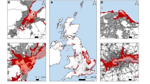
Quantifying UK coastal flood exposure under future sea-level rise to 2300
How will sea level rise affect flood risk to populations and critical infrastructure in the UK in the next few centuries? A study by the UK Met Office, Bristol University and Fathom has found that the number of people exposed to flood by 2300 could rise dramatically – but global reductions in greenhouse gas emissions could reduce these numbers.

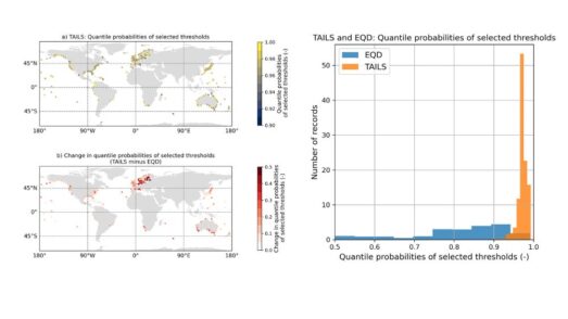
Automated tail-informed threshold selection for extreme coastal sea levels
A new method, TAILS, sharpens how we identify extreme events by focusing on the most critical data, giving clearer, more reliable estimates of future coastal hazards worldwide.
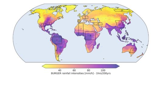
Introducing BURGER, Fathom’s new extreme rainfall dataset
New research by Fathom’s Senior Hydrologist, Dr Jannis Hoch, and other Fathom scientists describes Fathom’s new dataset, Bottom Up Regionalised Global Extreme Rainfall, or BURGER for short. It’s the first of its kind to be created from rainfall gauge data and the first to contain extreme estimates for durations as short as an hour.
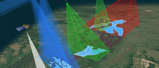
Satellite Requirements to Capture Water Propagation in Earth’s Rivers
Global River Topology (GRIT): A bifurcating river hydrography
Researchers have created the first branching global river network that represents bifurcations, multi-threaded channels and canals.