-
Rong, Y.,
-

-
-
Bell, P.,
-
Gommenginger, C.,
-
Lichtman, I.,
-
Banks, C.,
-
Calafat, F.,
-
Martin, A.,
-
Brown, J.,
-
Cooke, R.,
-
Balfour, C.,
-
Dominicis, M.,
-
Payo, M.,
-
Williams, S.,
-
Amoudry, L.,
-
Chuter, S.,
-
Neill, S.,
-
Chisholm, J.,
-
Kupiec, J.,
-
Lewis, M.,
-
Gleason, C.


A research team led by Fathom’s Prof. Paul Bates and including Dr Jeff Neal and Dr Stephen Chuter have carried out the first validation of the Surface Water and Ocean Topography (SWOT) in a coastal environment using LiDAR and tide gauges.
Sea levels are rising and storm surges are becoming more frequent due to climate change. Coastal cities are particularly vulnerable as they face a heightened risk of flooding, which is why accurately monitoring changes in water surface elevation along coastlines is so important.
However, the technology usually used for monitoring these changes, such as tidal gauges and traditional satellite altimeters, is limited. Improving satellite observations within about 10 km of the coastline is therefore a major scientific goal.
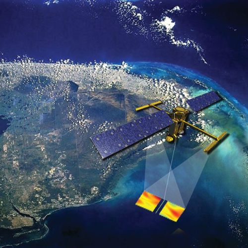
The Surface Water and Ocean Topography (SWOT) mission, led by NASA and launched in December 2022, represents a huge advancement in satellite measurement of the Earth’s oceans, major lakes, rivers and wetlands. Fathom’s Chair, Professor Paul Bates, was part of the original team which came up with the mission concept in 2004 and is still part of the SWOT Science Team, along with other Fathomers Dr Stephen Chuter and Dr Jeff Neal.
SWOT uses a Ka-band Radar Interferometer (KaRIn), which can measure water levels across a wide swath rather than a single narrow line, allowing it to capture much more detailed information and cover the entire planet every 10.5 days.
However, validating SWOT data in coastal environments with large tidal ranges is challenging. Validation requires highly accurate measurements taken at the same time and location as the satellite observations and the usual methods such as utilizing tide gauges may not represent the full spatial variability observed by SWOT.
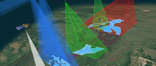
A study led by Prof Paul Bates and involving Dr Jeff Neal and Dr Stephen Chuter, set out to address this. They used in situ instruments along with airborne LiDAR data to evaluate SWOT measurements in the Bristol Channel in the UK. A new paper, led by Youtong Rong and published in Geophysical Research Letters, describes how they went about it.
Interested in how Fathom involve in SWOT project?
The research: Meeting the challenges of validating SWOT data
The Bristol Channel and Severn Estuary in the southwest of the UK has a tidal range of ~14m – the second largest in the world (after the Bay of Fundy in Canada). Its funnel-shaped geometry amplifies tidal energy and produces complex and dynamic conditions that determine extreme water levels and flood risk, which makes accurate monitoring essential.
The area was covered by SWOT’s 90-day daily fast-sampling orbit during the mission’s calibration phase from March to July 2023 and this, combined with the relatively dense LiDAR and in situ measurements, makes the site well suited for validating SWOT data.
The methodology: Choosing and processing the data
For the validation exercise, the researchers used:
- Three SWOT data sets: PIXC, Raster, and Unsmoothed SSH, which provide water surface elevation measurements at different spatial resolutions and processing levels.
- In situ instruments: Four gauges that comprise the water-level monitoring network in the Bristol channel plus two extra gauges installed at different points to fill coverage gaps. Two acoustic Doppler current profilers (ADCPs) equipped with pressure sensors were also mounted on the seabed offshore. These specialized hydroacoustic instruments measure the speed and direction of water currents in a vertical column rather than a single point.
- Airborne LIDAR: ~446 million LiDAR points, taken from five surveys conducted between April and June 2023, covering a wide range of tidal conditions from −5.1 m at low tide to +5.4 m at high tide.
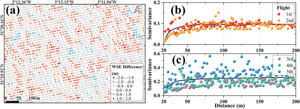
The researchers processed the LiDAR and tide gauge data, adjusting the measurements to align with the exact timing of SWOT overpasses, and they averaged the data to comparable spatial scales so they could compare satellite, airborne and in situ measurements.
The results: SWOT’s potential for monitoring coastal water levels
The study revealed that SWOT can make high accuracy water level measurements across a variety of tidal conditions: <10cm when averaged over 1km2 and <14 cm when averaged over a 100 m resolution grid. The instrument therefore shows strong potential for monitoring coastal water levels, provided correct data filtering and process is applied.
By combining LiDAR, pressure sensors, and tide gauges, the researchers were able to thoroughly assess SWOT’s performance, and established a reliable validation approach for future coastal SWOT measurements.
Want to dig deeper into the research published in Geophysical Research Letters?
Related paper
SWOT data will reshape our understanding of the global terrestrial water cycle
Just over a year after the SWOT satellite started sending its observation data to Earth, some of the scientists involved discuss how we can make the most of this unique resource.