
Despite improvements in remote sensing, many rivers are still not captured adequately. Researchers led by A Cerbelaud and including Fathom’s Chairman Professor Paul Bates, highlight advances in this area and identify key priorities for progress, including resolving narrow rivers, observing more often, using multiple satellites, and capturing new information to better reflect river flows.
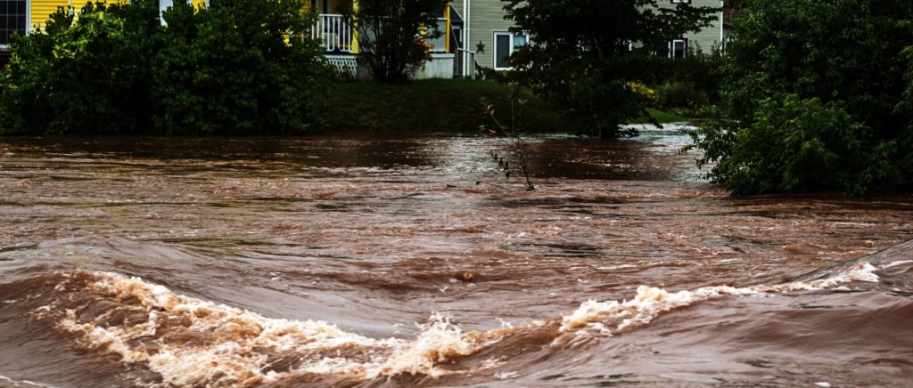
Understanding how water moves through Earth’s rivers is essential to manage global water resources and mitigate water-related disasters. This need is only growing as climate change affects the stability of our planet’s water cycle. Extreme weather events – from river flooding to coastal storm surges – are becoming increasingly common and severe, bringing with them devastating damages to human life and property.
However, it is difficult to obtain enough information on river flows and fluxes at adequate spatial and temporal scales on the ground, making remote sensing by satellite a vital tool for hydrographic monitoring. Such monitoring still suffers from key challenges: it remains unclear which specific properties of satellite data are required to accurately capture river dynamics (including the type, frequency, scale, spatial resolution, and accuracy of observation), and our models cannot yet fully compensate for data sparsity.
A research paper now reviews recent advances in remote sensing, identifying key priorities for progress and discussing how these could enhance our knowledge of river dynamics.
The state of play: How we currently watch Earth’s rivers from above
First, the researchers draw from academic research and satellite information to identify the five prevailing approaches currently used to observe rivers, monitor their changes, and estimate their discharge (by capturing properties such as surface elevation and water extent, river height and slope, and dry/wet ratios):
- Radar interferometry and wide swath altimetry (as used by SWOT)
- Passive microwave radiometry (AMSR-E, SMAP, SMOS)
- Multispectral optical imagery (MODIS, Sentinel-2, Landsat, Planet)
- Radar and laser nadir altimetry (Jason-1,2,3, Sentinel-3A/3B, ICESat-2)
- Active microwave SAR imagery (Terra-SAR-X, Sentinel-1)
They assess the efficacy of these methodologies to meet the observational needs of river monitoring, finding challenges with each. Based on this, they define the variables needed to more accurately capture water propagation and dynamics within river networks (including river width and various aspects of peak flow events – such as their duration, frequency, and the speed of associated waves).
Future priorities: How can we capture river dynamics more accurately?
The researchers conclude by identifying five key priorities for future progress:
- Fine sensing of narrow water bodies (less than 50–100 m in width). To capture global seasonal river patterns accurately, we need better measurements of the flows and discharge of narrow rivers.
- Improved understanding of how river variability relates to measurement accuracy. Surface water-related variables generally co-vary. We need to understand their trade-offs to determine how to measure them.
- Observing more frequently on a 2-day repeat cycle, sufficient to resolve the dynamics of most rivers. While current 10- to 25-day cycles can capture long-term and seasonal patterns, they miss peak event timing and duration – crucial for early warning systems and monitoring of flood propagation.
- Modeling river systems and using multi-sensor approaches. Better modeling would improve estimates of inundation extent – key to flood risk modeling – while multi-sensor merging could better capture frequent flow events to improve flood map accuracy.
- Measuring new variables to better capture water flux and discharge. Current satellite systems only observe half the variables we need, leaving multiple unknowns.
The researchers highlight that remote sensing of rivers has until now been largely opportunistic, benefiting from instruments designed to study oceans or land. They call for more purposeful design of systems tailored to river observation and propose a solution: a targeted satellite akin to SWOT to gather advanced data, supported by a cost-effective constellation to complete more frequent observations of river dynamics.
Interested in learning more? Find the full details of the research paper.


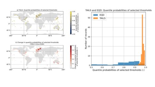
Automated tail-informed threshold selection for extreme coastal sea levels
A new method, TAILS, sharpens how we identify extreme events by focusing on the most critical data, giving clearer, more reliable estimates of future coastal hazards worldwide.
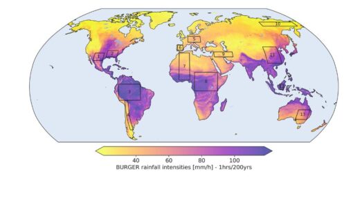
Introducing BURGER, Fathom’s new extreme rainfall dataset
New research by Fathom’s Senior Hydrologist, Dr Jannis Hoch, and other Fathom scientists describes Fathom’s new dataset, Bottom Up Regionalised Global Extreme Rainfall, or BURGER for short. It’s the first of its kind to be created from rainfall gauge data and the first to contain extreme estimates for durations as short as an hour.
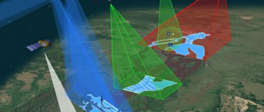
Satellite Requirements to Capture Water Propagation in Earth’s Rivers
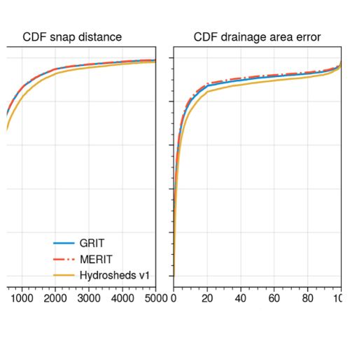
Global River Topology (GRIT): A bifurcating river hydrography
Researchers have created the first branching global river network that represents bifurcations, multi-threaded channels and canals.

FathomDEM Global Terrain Map
A new research paper published in Environmental Research Letters outlines the creation of FathomDEM, a new global 30 m DEM produced using a novel machine-learning approach.