Florida flood map: Understanding future risk with data and modeling
Flood risk in Florida
Flooding is the most frequent hazard in Florida. The state is situated on a low-lying peninsula, surrounded by the Atlantic Ocean and the Gulf of Mexico, and its low elevation and coastal location combined with a subtropical to tropical climate makes it vulnerable to hurricanes, storms and floods at any time of year.
Storm surges can travel far inland, causing devastating floods that are damaging and deadly.
The Florida Climate Center estimates that 90% of deaths from hurricanes in Florida are from drowning in storm surges and flood waters. And the need to repeatedly rebuild and repair damaged property means flooding is also costly.
The cost of flooding in Florida
According to the Florida data in our US Flood Risk Index, average annual losses (the expected long-term losses per year) due to flooding were high at $4.3bn in 2020, but that figure will increase significantly between 2020 and 2050.
Figures from Fathom’s US Flood Risk Index:
- $4.3bn – Average annual losses due to flooding in Florida in 2020
- $7.4bn – Average annual losses due to flooding in 2050
- 73.6% – Increase in average annual losses between 2020 and 2050
- 27.6% – National average increase in average annual losses 2020-2050
- $1.6bn – AAL occurring outside of FEMA Special Flood Hazard Areas (2020)
The state is well covered by official Florida flood maps. Almost all of the state (99.9%) is covered by FEMA Flood Rate Insurance Maps (FIRMs) but more than 60.3% of those maps are older than 10 years.
Fathom’s own research has found that $1.6bn of 2020’s project AAL losses occurred outside FEMA’s Special Flood Hazard Areas. These are the high-risk flood zones designated by FEMA’s FIRMs. The fact that large losses occur outside those zones tells us that flood risk in Florida is potentially under-represented.
Find more flood risk insights for Florida and all other US states in Fathom’s US Flood Risk Index
Assessing vulnerability for critical infrastructure in Florida
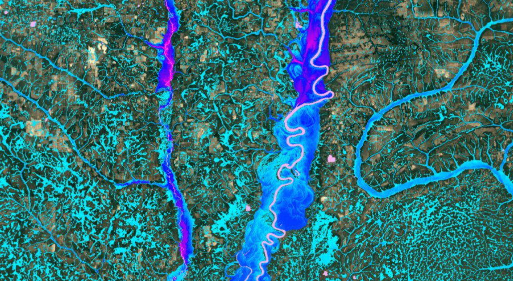
Fathom has worked extensively with various public bodies to understand Florida’s flood risk. One of these was the Florida Department of Environmental Protection (FDEP) Office of Resilience and Coastal Protection, which set out to deliver a comprehensive statewide flood vulnerability assessment for critical infrastructure.
In partnership with Taylor Engineering and Jones Edmunds, Fathom applied its US flood modeling framework to develop a bespoke, fully 2D statewide model. The analysis captured coastal, pluvial and fluvial flood risk under both current and future climate scenarios, providing Florida with a robust, forward-looking understanding of flood exposure.
Validating Fathom’s data for the Florida flood map project
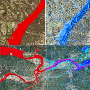
The first step in the Florida Department of Environmental Protection (FDEP)’s statewide flood vulnerability assessment (see above) was to independently evaluate Fathom’s data.
First, Jones Edmunds, a Florida-based engineering firm and a partner on the project, compared Fathom’s high-resolution pluvial and fluvial Florida flood risk data to FEMA Florida flood maps to ensure strong alignment with established flood hazard data across the state. Secondly, they compared Fathom’s data to 13 more detailed, local-scale studies.
Methodology
Model performance was assessed using standard validation metrics, including overall agreement (critical success index), the proportion of FEMA flood areas correctly captured (hit rate), and the extent of areas predicted as flooded by Fathom but not shown in FEMA maps (false alarm ratio).
Results
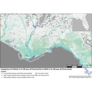
- There was strong agreement between Fathom’s Florida flood map and FEMA’s mapping, particularly in high-risk areas.
- Fathom achieved hit rates of 0.86 for detailed AE zones and 0.79 for 100-year flood zones, while maintaining a very low false alarm ratio of 0.02.
- The high Critical Success Index (CSI) score of 0.78–0.85 demonstrates close alignment with FEMA’s flood hazard data.
Understanding Florida’s future flood risk
While FEMA maps provide an important benchmark, they are typically based on historical conditions. Fathom’s modeling goes further by supporting forward-looking analysis such as Florida flood maps for 2050, helping organizations understand how Florida flood risk may evolve under future conditions, growing urbanization, and changing rainfall patterns.
Combined with official FEMA data and detailed outputs such as flood elevation maps for Florida, this enables insurers, engineers and government bodies to better assess current and future flood risk across Florida.
Explore our Florida validation case study to learn more about the methodology and results.
Understanding Florida’s future flood risk with Climate Dynamics
Florida’s current flood risk is high because of its topography and coastal location. There is accessible and comprehensive flood data that tells us which areas are at particularly high risk: FEMA maps cover 99.9% of the state and annual average losses (AAL), which is a metric insurers use to measure the expected losses due to floods averaged over any given year, are already high.
However, FEMA maps rely solely on historic data. This can lead to misrepresentation of flood risk because it ignores any potential changes in land-use, climate, population growth and urbanization. A US flood map that presents a more realistic view of flood risk should be based on historic data combined with climate change projections and other future scenarios.
Fathom’s Climate Dynamics framework for Florida’s future flood risk projections
Flood risk in Florida is influenced not only by geography and terrain but also by climate conditions, including extreme rainfall, tropical storms, and changing weather patterns.
Fathom’s flood maps and models incorporate our Climate Dynamics framework, an innovative solution created by Fathom to model how flood risk can change in the future under various climate scenarios.
By using a change-factor approach (relative change in a variable, per degree of warming) Fathom is able to meet the technical challenge of combining high-resolution flood maps with future climate projections. The result is a fully customizable view of risk under different time horizons, climate scenarios and warming levels, under any plausible future up to 2100.
This approach provides a more comprehensive representation of flood exposure across Florida, helping organisations understand both current and future flood risk.
Learn more about Fathom’s Climate Dynamics framework
Hurricanes and flood risk in Florida
Florida is widely associated with hurricanes and storm surge along the coast but, as recent devastating events have shown, flooding is also a deadly hazard inland.
When hurricanes make landfall, they can produce extreme rainfall over large areas for long periods. This can overwhelm drainage systems, cause rivers and lakes to overtop and lead to extreme pluvial (rainfall-driven) and fluvial (river) flooding hundreds of miles inland.
Why hurricanes cause inland flooding
Hurricanes and tropical cyclones can generate severe inland flood events for several reasons:
- Extreme rainfall – Hurricanes can deliver hundreds of millimetres of rain in a short amount of time.
- Slow-moving storms – Rainfall accumulates over the same area for prolonged periods.
- Large footprint – Tropical systems can produce heavy rainfall hundreds of miles from the storm centre.
- Saturated ground conditions – High rainfall in the days running up to a hurricane or storm can reduce the soil’s ability to absorb water, which increases runoff and causes flooding.
Mapping hurricane-driven flood risk
Understanding this multiperil flood risk requires high-resolution flood modeling that captures rainfall-driven (pluvial) and river (fluvial) flooding as well as coastal inundation.
Fathom’s US flood map incorporates both pluvial,fluvial and coastal flooding, enabling users to assess flood exposure from extreme rainfall events, including those associated with hurricanes. This provides a more complete picture of Florida flood risk, complementing traditional coastal-focused flood maps.
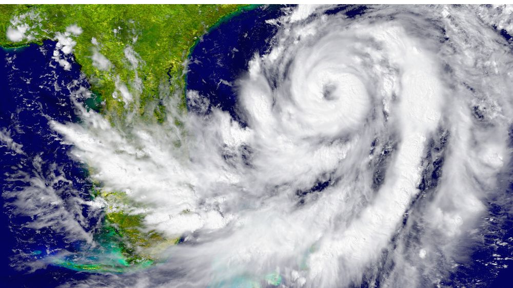
Hurricanes Helene and Milton: what they reveal about Florida’s flood risk
In September 2024, hurricane Helene made landfall near Perry in Florida. According to the National Oceanic and Atmospheric Administration (NOAA), Helene was the deadliest Atlantic hurricane to strike the US mainland since Katrina in 2005 and the total costs were an estimated $78.7 billion.
A couple of weeks later, hurricane Milton made landfall in Florida’s Siesta Key. With sustained winds of 120 mph, NOAA estimated the cost of the damage it caused was $34.3bn.
Both events highlight how flood risk from tropical storms extends far beyond coastal storm surge. Extreme rainfall triggered widespread inland flooding, affecting communities hundreds of miles from landfall and demonstrating the growing importance of rainfall-driven flood risk.
Fathom’s analysis explores how these storms developed, the drivers behind the flooding, and what they reveal about future hurricane impacts.
Fathom’s flood mapping in Florida
Understanding flood risk in Florida requires high-resolution flood maps and models that reflect the state’s unique geography, rainfall patterns and coastal flood risk, both now and under future conditions.
Fathom’s US Flood Map provides a detailed view of flood hazard across Florida, helping businesses, insurers, engineering and public sector professionals assess flood risk with greater confidence.
High-resolution terrain data for accurate Florida flood mapping
Terrain plays a critical role in determining where floodwater flows and accumulates. Fathom’s flood maps are underpinned by some of the most detailed digital terrain datasets available for the United States.
This dataset combines high-quality LiDAR elevation data with advanced terrain processing techniques to produce a consistent representation of flood risk in Florida.
Florida benefits from extensive improvements in this dataset, including enhanced LiDAR coverage and refined elevation modeling that better represents the state’s complex flood risk.
Key features of Fathom’s Florida flood map
Fathom’s flood modeling framework is designed to support a wide range of flood risk applications.
Key features include:
Built on detailed, accurate terrain data and advanced hydrodynamic modeling
Extensive LiDAR elevation data, with significant terrain improvements across Florida
Physically based flood models that simulate how water flows across the terrain
Coverage of multiple flood perils – pluvial (rainfall-driven), fluvial (river) and coastal
Climate-informed flood risk estimates – Underpinned by Fathom’s Climate Dynamics framework, Fathom’s flood map of Florida represents present-day flood hazard as well as how that risk may change under different climate scenarios
Data ready for integration into analytics platforms, catastrophe models and mapping tools
Learn more about Fathom’s US Flood Map, the most technologically advanced, country-wide flood map for the United States
Who can benefit from Florida flood map
Fathom’s Florida flood map and flood risk data support a wide range of organizations that need accurate, high-resolution insight into flood exposure across the state. From insurers and real estate professionals to infrastructure planners and climate risk analysts, the data helps users understand where flooding could occur today and how risk could evolve in the future.
Insurance and reinsurance
Flood risk is a critical factor for insurers operating in Florida, where exposure to rainfall flooding, river flooding and storm surge can vary significantly across locations. Fathom’s flood modeling technology helps insurers quantify flood exposure, support underwriting decisions and inform pricing decisions.
Fathom and Aon’s certified Florida flood model
In collaboration with global professional services firm Aon, Fathom developed the Florida flood model, which has been formally certified by the Florida Commission on Hurricane Loss Projection Methodology for use in insurers’ rate filings in the state.
Built using Fathom’s high-resolution flood modeling framework alongside Aon’s catastrophe modelling expertise, the Florida model captures flood risk from tropical and non-tropical weather systems and represents all major flood perils affecting Florida, including river (fluvial), rainfall-driven (pluvial) and coastal flooding.
The Florida flood model helps insurers better understand potential losses and manage their flood exposure.
Learn more about how Fathom and AON collaborated to support the insurance industry in Florida

Real estate and property professionals
Property buyers, lenders and real estate professionals have a growing need to understand flood risk at the property level. Fathom’s Florida flood map provides detailed flood hazard information that can support:
- Property due diligence
- Mortgage risk assessment
- Portfolio risk screening
Climate risk disclosure and reporting
High-resolution flood data helps stakeholders move beyond coarse flood zone classifications and gain a clearer view of potential flood exposure.
Infrastructure and urban planning
Infrastructure operators, utilities and planners need accurate flood risk data to design resilient systems and protect critical assets. Detailed terrain modeling and hydrodynamic simulation identify where floodwater is likely to flow and accumulate across Florida’s landscape.
Fathom’s flood maps support:
- Infrastructure resilience planning
- Transportation and utility risk assessments
- Flood mitigation strategy development
- Long-term infrastructure investment decisions
Climate risk analysis and reporting
As climate risk disclosure requirements increase and evolve, organizations are required to quantify and report their exposure to physical climate hazards.
Fathom’s flood risk data provides a robust foundation for climate risk analysis in Florida, enabling organizations to evaluate both present-day flood exposure and how risk may change under different climate scenarios.
This makes the data particularly valuable for financial institutions, asset managers and corporate risk teams conducting climate risk assessments or regulatory reporting.