-
Flores, A.,
-
Collins, T.,
-
Grineski, S.,
-
Amodeo, M.,
-
Porter, J.,
-
Sampson, C.,
-


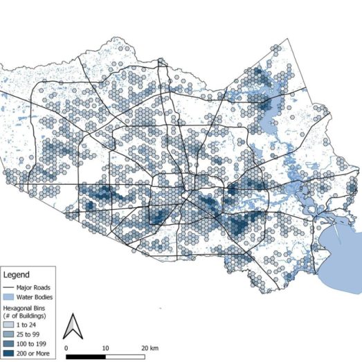
New research, co-authored by Fathom’s Dr Oliver Wing and using Fathom’s US Flood Map, reveals that almost a million residents live in overlooked 100-year flood zones in Greater Houston Texas, with Hispanic, Black and Asian populations at disproportionate risk.
Like many large urban areas in the US, Houston has experienced increased flood risk in recent decades, largely due to climate change, ongoing urbanization and floodplain development.
The Federal Emergency Management Agency (FEMA) delineates 100-year flood zones (an area that has 1% chance of flooding in any given year) across the US. These flood zones are then used to assess risk, set insurance premiums and inform policy and investment.
However, many of the maps that FEMA relies on to define these flood zones are outdated and there are large gaps in coverage, which means the understanding of flood risk in many parts of the US could be inaccurate.
The authors of this research paper address this by using Fathom’s US Flood Map together with sociodemographic data to analyze population exposure and flood risk inequities in Greater Houston.
The research: State-of-the-art population data and flood modeling
The study explores these questions:
- How many people live in federally overlooked 100-year flood zones in Houston (i.e. areas that are at risk of 100-year flood but are outside the FEMA-designated zones)?
- Which social inequities are associated with the overlooked 100-year flood risk?
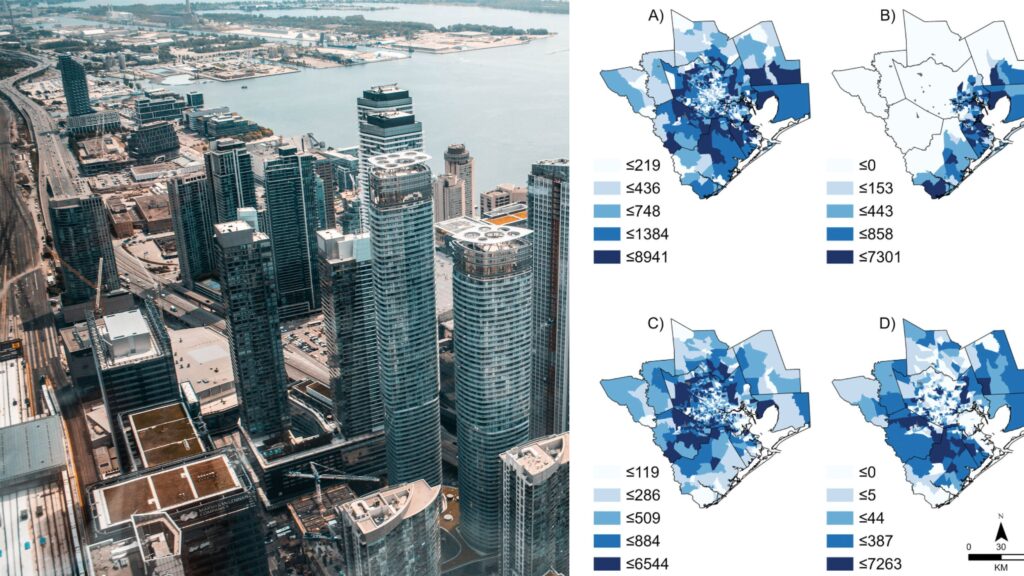
- How do these social inequities vary by flood type (pluvial, fluvial and coastal)?
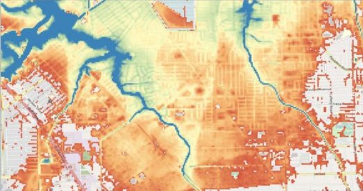
To analyze flood risk, the researchers used Fathom’s state-of-the-art US Flood Map to identify areas outside the FEMA 100-year zones. This model covers 100% of US waterways compared with the 60% covered by FEMA, and it estimates flood risk under different climate change scenarios whereas FEMA relies on historical observations.
Next, the team used dasymetrically mapped sociodemographic data to assess inequities in the population’s exposure to flood risk. This advanced technique gives a more accurate picture of population distribution and a better estimate of exposure than methods used in most previous studies.
Key findings
The results indicate three key findings:
- Almost 1 million Greater Houston residents live in 100-year flood zones overlooked by FEMA
- Specific racial and ethnic groups living in the overlooked zones face greater flood risks
- Black and Asian communities in overlooked 100-year zones are disproportionately affected by pluvial and fluvial flooding; Hispanic communities face higher risks of all types of flooding, including coastal
The greater flood risk experienced by residents outside the FEMA-designated zones is compounded by a lack of adequate protection and support, making these communities particularly vulnerable.
While the paper notes the uncertainties in flood modeling and the need for further investigation, the results help shed light on a public policy issue and suggest that targeted investment is needed to address flood risk inequities in Greater Houston.
Learn more about this research by downloading the research paper
Related research
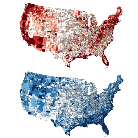
Inequitable patterns of US flood risk in the Anthropocene
Climate change will have major impact on cost of flooding, according to pioneering research led by Dr Oliver Wing, Chief Research Officer at Fathom
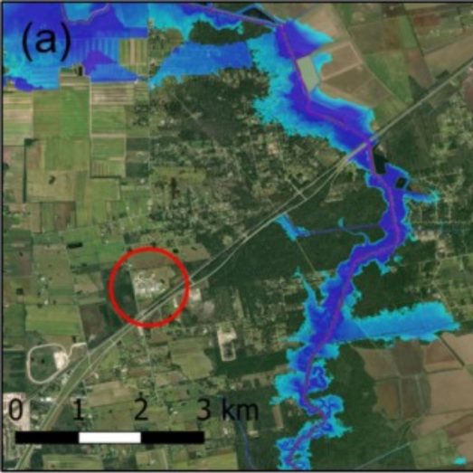
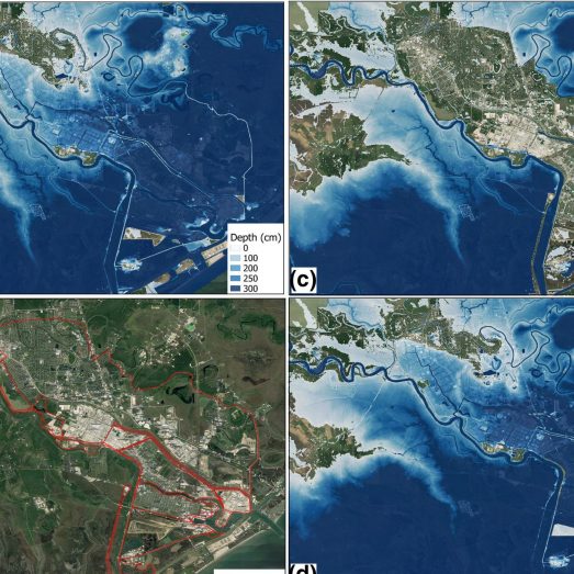
A flood inundation forecast of Hurricane Harvey
A paper describing our rapid flood forecasting model, tested against Hurricane Harvey.
Attributable human-induced changes in the magnitude of flooding in the Houston, Texas region during Hurricane Harvey
Using Fathom’s US flood model to examine how climate change exacerbated the impact of Hurricane Harvey, which devastated Houston in 2017.
Combined Modeling of US Fluvial, Pluvial, and Coastal Flood Hazard Under Current and Future Climates
A paper describing our most recent iteration of the US model, covering inland and coastal flooding across multiple time horizons.
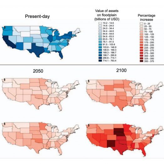
Estimates of present and future flood risk in the conterminous United States
A collaboration with the US EPA and The Nature Conservancy to show that: a) previous estimates have significantly underestimated exposure of US population to flood risk; and b) that population and GDP growth are likely to cause this to further increase in future.

New insights into US flood vulnerability revealed from flood insurance big data
Nature Comms paper describing our work on flood vulnerability functions using >2 million NFIP claims.
Social inequalities in climate change-attributed impacts of Hurricane Harvey
This research uses attribution science to examine the influence that climate change had on the damage caused by Hurricane Harvey in 2017.