FABDEM
License FABDEM today
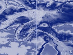
Introducing FABDEM – a new 30m global terrain dataset
Using machine learning, researchers from the University of Bristol and Fathom have removed building and tree artefacts from Copernicus GLO-30 DEM. The result is the most accurate complete map of the Earth’s terrain ever built. The new elevation map is more accurate than existing global elevation maps and will strengthen applications and models where high quality global terrain information is required.
This data is available under a commercial license or free for non-commercial use.
The developers of FABDEM will be discuss the terrain data in detail in our latest webinar, watch here.