Request a download our free event footprint of Hurricane Ida
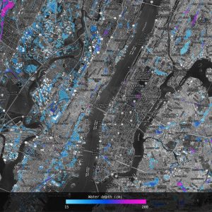
Fathom have created an event footprint for the mid-Atlantic precipitation event using simulations based on observed rainfall accumulations from NOAA and river gauges from the USGS. As ever, there is more uncertainty with the pluvial coverage away from the main rivers due to the fact that we don’t have detailed information about exactly how the rain fell.
Once you have submitted the request form, a member of the Fathom team will contact you direct.
Please note, that this data cannot be used for commercial use*.
The data layer itself is called ‘Ida_NE_fooprint_DATA.tif’. It is WGS84 projected, 1 arcsecond (~30m) resolution, with maximum simulated depth in cm. A value of ‘9999’ is used to represent permanent water.
*By downloading the flood footprint you agree that Fathom does not warrant that the data layer is accurate, complete, reliable, secure, useful, fit for purpose or timely; or the data layer has been tested for use by you the recipient or any third party or that the Data will be suitable for or be capable of being used by you or any third party and that Fathom shall not be liable for any loss whatsoever from the use of this data.