Cyclone Amphan, Bay of Bengal 2020


Fathom teamed up with HR Wallingford this week to forecast the impacts of Cyclone Amphan in the Bay of Bengal, as part of a UK aid project co-ordinated by the UK Department for International Development.
Event start
May 20, 2020Date of forecast
20.5.2020Report issuing date
21st May 2020HR Wallingford modelled surge heights based on forecasts from the India Meteorological Department, which were then used as input to Fathom’s 2D hydrodynamic model. Full details are available below.
Situation summary
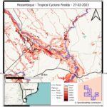
Cyclone Amphan is due to make landfall on 20th May 2020. Heavy rainfall and an extreme storm surge are expected. The cyclone is due to hit low-lying delta regions, exacerbating the impact of potential inundation.
Inundation forecast methods
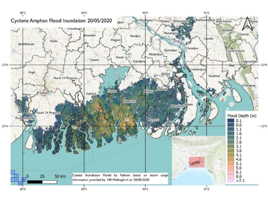
This report uses storm surge forecasts produced by HR Wallingford, based on India Meteorological Department cyclone track forecast at 16:00 UTC (19/05/2020 Model Reference time) to drive Fathom inundation model. Maximum tidal height is assumed. Flood defences are not included. This model is subject to significant uncertainties but shows indicative figures.
Summary of potential impacts
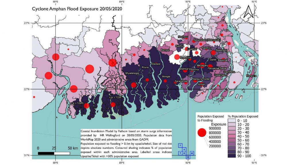
Overall exposure to flooding
~15 million people exposed to >0.1m flooding across Bangladesh and NE India.
Flood exposure in Bangladesh
~9.7 million people. In some provinces >90% of the total population are exposed. The Barisal and Khulna Divisions have the highest forecast exposure (Bangladesh). Barisal Division has highest risk to >1m flooding, reducing significantly for >3m flood depth.
Flood exposure in India
~5.3 million people overall. In the South 24 Parganas district >1.5 million people are exposed (India). ~1 million exposed to >1m flooding; ~190,000 to >3m flooding.
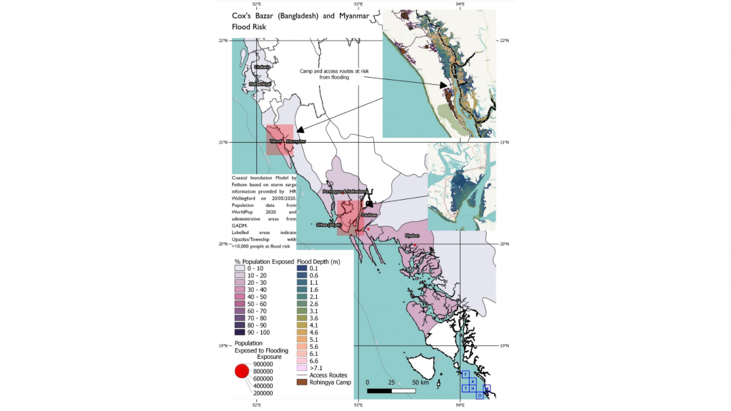
Flood exposure in Myanmar
~0.25 million people. In Myanmar, greatest numbers are exposed to shallow flooding (>0.1m) in Ponnagyun & Rathedaung Township (62,100). In Sittwe (Akyab) Township, 42,600 exposed to 0.1m flooding with 4,700 at risk from >3m flooding.
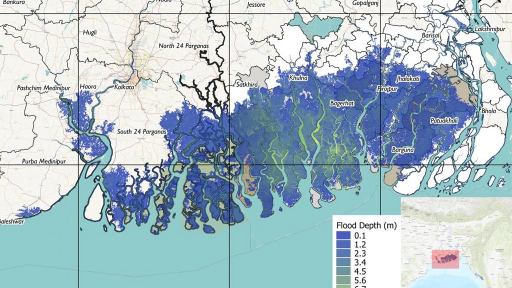
Estimated levels of storm surge
4-6m storm surge in some worst hit areas including Bogerhat, Khulna, Satkhira.
Regions at risk of >3m of flooding
Khorya, Bagerhat, Satkhira and Mongla (Khulna Division), exposing >50,000 people to this risk.
Areas most likely to experience flooding
Widespread flooding in Patuakhali, Pirojpur, Bagerhat, Jhalokati, Barisal (Bangladesh). Also possible flooding in Narayanganj, nr Dhaka (Bangladesh). N8 Road south of Barisal (Bangladesh) likely to flood.
Highest exposure
The largest total exposed populations at a state/district level are in the state of West Bengal (India).
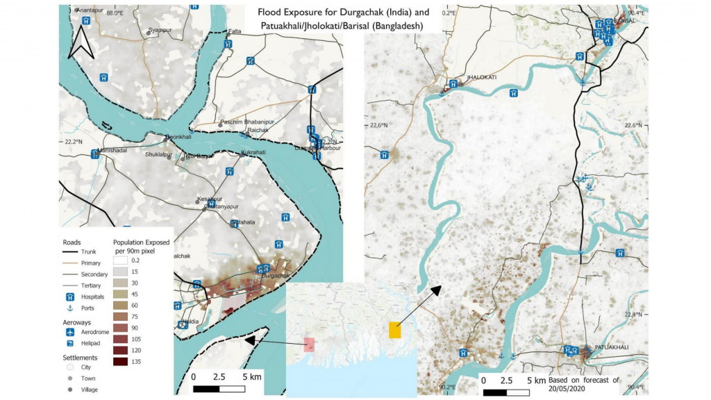
Risk to refugee camps
Rohingya Refugee Camps at risk from flooding (Camp 25/Alikhali) in Teknaf, Cox’s Bazar (Bangladesh). Also access routes to the camps.
Report partners

Inundation forecast method
Modelling approach and limitations
Cyclone track: India Met Department forecast Storm surge modelling: HR Wallingford Inundation modelling: Fathom/University of Bristol Population data: WorldPop.
The modelling approach applied here uses storm surge water height forecasts to drive a 2-D inundation model. This model is subject to significant uncertainties both in the surge forecasts and in the inundation simulations. This is not an operational product. No evaluation of this approach has been undertaken to date, rather the data represent a best effort given the immediate need for information. Moreover, the simulations are strictly simulating storm surge inundation and do not account for precipitation driven inundation at this stage. There are no flood defences included in the model, likely contributing to over prediction of exposure in areas benefiting from defences, and it has been built using a global terrain dataset MERIT DEM. Although the best available global terrain dataset for flood modelling, this data is subject to large errors (>2m in 40% of cells) and has a spatial resolution of ~90m. Therefore, it is only suitable for exposure and risk analysis at larger scales. The exposure analysis conducted here uses WorldPop data to provide estimates of the total population exposed. These population data are also subject to substantial uncertainties and are only suitable for large scale, aggregated exposure estimates.
Correspondence: Please direct technical enquiries to Dr Andrew Smith (a.smith@fathom.global). For all other enquiries please contact Dr Rosalind West (rwest@dfid.gov.uk) or Katherine Marsden (k-marsden@dfid.gov.uk).
*This is a research product for situational awareness only, coordinated by the UK Department for International Development Research & Evidence Division. It may be disseminated freely.

More response reports